-
Welcome to this forum . We are a worldwide group with a common interest in Birmingham and its history. While here, please follow a few simple rules. We ask that you respect other members, thank those who have helped you and please keep your contributions on-topic with the thread.
We do hope you enjoy your visit. BHF Admin Team
You are using an out of date browser. It may not display this or other websites correctly.
You should upgrade or use an alternative browser.
You should upgrade or use an alternative browser.
springfield road moseley
- Thread starter Astoness
- Start date
pjmburns
master brummie
I think this is it today - I say ",think" as there are 2 Springfield Roads neither of which today I would call Moseley
(this one starts at Stratford Road and ends on Wake Green Road which has a Moseley postcode). This is tge Stratfford Road end.

The other is closer to King's Heath.
(this one starts at Stratford Road and ends on Wake Green Road which has a Moseley postcode). This is tge Stratfford Road end.
The other is closer to King's Heath.
pjmburns
master brummie
Actually I now wonder if it was a view in the opposite direction. Taken from round that top bend and facing the other way.

BrummieGeoff
Sparkhill Lad
Radiorails
master brummie
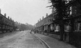
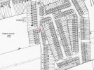
The Springfield Road photo was posted by Phil, on BHF and was dated as 1903. the map shown would have been where the allotments were - left hand side of the pic. It was on the 29A bus route, which started in 1936, to take in all the new developments in Hall Green which were not covered by the 29 or 37 routes.
pjmburns
master brummie
That makes it the view in post #3 looking towards college Road island.The photo is taken looking south along Springfield Road .... the horse and cart are outside the detached house at No 59, which I think is still standing.
View attachment 208083
Edit: No it doesn't - see reply in next post lol
Last edited:
BrummieGeoff
Sparkhill Lad
No, it's looking away from College Road.
pjmburns
master brummie
Oops I just saw Passey Road - in that case post #2No, it's looking away from College Road.
devonjim
master brummie
In 1950's until 1956 the cricket grounds were our school playing fields, rugby as well as cricket. They were on the right just up from College Rd. That was KEGS Camp Hill prior to their move to Kings Heath.The photo is taken looking south along Springfield Road .... the horse and cart are outside the detached house at No 59, which I think is still standing.
View attachment 208083
Last edited:


