-
Welcome to this forum . We are a worldwide group with a common interest in Birmingham and its history. While here, please follow a few simple rules. We ask that you respect other members, thank those who have helped you and please keep your contributions on-topic with the thread.
We do hope you enjoy your visit. BHF Admin Team
You are using an out of date browser. It may not display this or other websites correctly.
You should upgrade or use an alternative browser.
You should upgrade or use an alternative browser.
Spring Hill Passage
- Thread starter josietrue
- Start date
Hi Josie
If you are looking for spring hill passage from the library head towards dudley road sorry its now called
City Hospital. If you stand at the front entrance of the library with your back to the front entrance raise your right arm and turn
And start walking the dudley road it is about a quarter of a mile along the road and it will be first road on your left hand
Which is still there so cross over the road and you are there I had a couple of friends up that passage
The knights family related to the Adams family and my very close friends from boy to man whom as died like most
Of the family are the frisbys there was a Mr and Mrs frisby Brian , frisby graham frisby and an Alan frisby
Whom was a bakery delivery MSN for the co/op when the houses of the passage was demolished they kept the little factory's
To be honest it was a huge factory called prices the manufactory of cuterly and silver ware world wide
Employed hundreds of people the building still stands but it been let into little I dependant business units
And what was the school gates where the care tater lived still stands he was Mr limb and his family
The old class rooms of the nursery are still there as you walk up the passage way the passage way now is a complete mess and rubble and the school playground is a scrap yard and skips you will come to stour street and the incline of the hill facing you is the remains of what was little kingedwards road they have destroyed it what for I will never know
I do believe some where that some one as got a picture of it with the houses I have got one myself some where
Okay best wishes Astonian,,,,Alan,,,,
Hi mike
I am sure Josie will find that map very helpful indeed I just wanted to say the software ware housing
At the top of inglby street comes to the corner of monument road which was the old Pallidesal ballroom dancing.
Many years ago and it was bulpitts storage from there other half of there factory which was on spring hill
As we all know many thanks for the map true to form always with your maps
You must have a great grand color action, I actually lived just on the next corner of inglby street
And Dr Tracy whom was a surgeon at dudley road hospital whom incidently brought me into
This great big world at dudley road, and directly oppersite that ware house in those years
Was his surgery for all us local people in is surgery office door he had a double joined door
So when you open end the door to walk into his office you step in and the inner door open end and the one you open end
Just closed behind you a very good doctor indeed
He had a big house in Selwyn road edgbaston just off gilliot red his house backed onto our school playing fields
This was in the fifty, there is a picture of our house in the old Ladywood forum and in the books of brum
Many thanks again mike Alan,,,Astonian,,,,
Phil
Gone, but not forgotten.
Josie
If you take a look here,
https://www.oldladywood.co.uk/springhillpassage.htm
You will see several photos of Spring Hill Passage taken in 1964, you can even make out number 35 on one of them,
If you take a look here,
https://www.oldladywood.co.uk/springhillpassage.htm
You will see several photos of Spring Hill Passage taken in 1964, you can even make out number 35 on one of them,
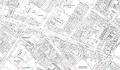
I should actually apologise also. I have found it before for someone, but got a bit confused as the road is now called Stratford St North, and I had forgotten my previous experience with the name. The map shows Devey's buildings in pink . (The map was made for the previous enquirer, so the blue buildings are Diamond Place). No 7 is the seventh along the top. I nave coloured it a purple to distinguish it
Attachments
Last edited:
Hi mike,Phil, and of course Josie,
Many thanks to the three of you,for tracking down the photos of spring hill, and of course
Steward street school where as a nipper I attended and lived up the hill from the school
It brought many memories for me indeed , I know over the years that neck of the woods as been
Mentioniond but no pic, with it so that's great
Photo number 1. Was the beginning of spring hill coming down the hill of what was known as little
Kingedwards rd it was at an angle. The light grey brick work with just habit of a window showing
Was old lady Mrs Mitchell whom a little old lady a tiny lady whom cared for the local kids
She sold provisions but she supplied us kids with sweets to and from school
She knew us kids had hardley any money for sweets so she made up two trays of sweets
And she called them 1. Tray the penny tray which was a mixture of sweets some was a penny
Some was half penny,like black jacks sweets four for a penny etc
Tray number 2, was the three penny tray, better selection of sweets etc,
But because she was very short sighted and half blind the older kids try copping her saying
To her Mitch, as we all called I gave you a shilling , some times she fell for it but some times
She cottoned on and told them get of the shop to enter her shop it was a little alley way
And turn left into it it was virtually her home with a little home made counter
If there was four ,kids in that little room it was packed when busy she would call for her daughter
To come out of the back room to sort us all out, the first house showing with the pram out side
The House was the Davis family whom have been there for decades there son was jimmy
Whom followed in his father foot steps as he was a fireman on the steam locomotives railways
Photo 2. Was the front gates of stewards street school and the house next to it was then in the 1956/7
Was a Mr Limb and his family just inside the gates on the left of the gates was the day nursery
Then look right of the lamp post was prices internationals cutlery muskets of alsorts of metals
World wide silver ware, photo number 3. As follows,,,,,,,,,,
The shop at the bottom of spring hill or you could say the beginning of spring hill
And the corner of inglby street the shop was Mrs peacocks provisions sweets and second clothes
And my dear friends at that time and for many years thirty or more years on until he died
Was graham frisby and is mother was olive frisby whom was well known for adopting little kids
They move with the clearance to western road number 47 ,
Thanks guys for the memory and a special thanks to Josie for requesting it and with out that
I would not have had the memory best wishes guys AS always Alan,,,ASTONIAN,,,,
hi josie...ive just remembered that i think the numbering of hospital st changed in the 1880s so i think it maybe best to wait to see if mike has a map before the change as although no 61 was the globe pub in the 1920s it may not have been when your rellies lived at 61..
lyn
lyn
In 1884, 61 Hospital St was John West Beer Retailer, In 1888 61 Hospital St was John West Beer Retailer. So I think it's safe to assume that in 1885 it was the same.
thanks phil...well fancy that josie
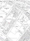
I know this is an old post but wonder if you could help me. Is it possible to extend the area of this map to the right so that it shows the area of Spring Hill up to the Monument Road junction?josie
No 35 is shown in red on the c 1950 map below
Thank you Mike for your super rapid response. Exactly what I wanted.
jmadone
master brummie
Mike do you have a map showing the whole of Steward St? I am looking for 7 back of 77 Steward St. as this was where my father was born in 1924. Thank you in anticipation.
Jim
jmadone
master brummie
Mike that is really great, thank you most sincerely.
First, apologies for posting here, it should really be on the Spring Hill post, but it caught my I eye!
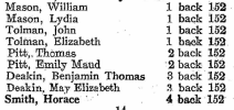
Mike - Thank you for enlarging that map! The house at the back of 152 on Spring Hill appears to be 2/152 whereas it should be 1/152. This is where my great-grand parents lived from about 1920-1946, until my great-grandfather died in Western Road Hospital (Dudley Road)
Dave H
Last edited:


