• Welcome to this forum . We are a worldwide group with a common interest in Birmingham and its history. While here, please follow a few simple rules. We ask that you respect other members, thank those who have helped you and please keep your contributions on-topic with the thread.

    We do hope you enjoy your visit. BHF Admin Team

Overton Place

margessister

proper brummie kid
Has anyone got any information at all about this area? My dad lived there in later 1939 and 1940s
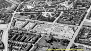
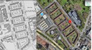
His address was Overton Place, Barrack street ( 1939 register )
Thanks in advance
Annette
 
hi...click on below link to take you to a map of barrack st...as you can see there is only one place that overton place could have been as the whole left side of the street was taken up by the arm barracks and the top square on the right was st james the less church and graveyard leaving the houses that backed onto critchley st..this is my best guess if you move the blue dot the old map will fade out to show you what is there now

lyn

 
Last edited:
hi...click on below link to take you to a map of barrack st...as you can see there is only one place that overton place could have been as the whole left side of the street was taken up by the arm barracks and the top square on the right was st james the less church and graveyard leaving the houses that backed onto critchley st..this is my best guess if you move the blue dot the old map will fade out to show you what is there now

lyn

thank you very much
 
just found this map which may be better for you...you can see the barracks taking up all of the left side of barrack st..top right is the church and graveyard then next to that are the only dwelling houses i can see so i am assuming that overton place must have been somewhere there.if any of our map experts spot this thread they maybe able to pinpoint overton place for you

image (65).jpg
 
just found this map which may be better for you...you can see the barracks taking up all of the left side of barrack st..top right is the church and graveyard then next to that are the only dwelling houses i can see so i am assuming that overton place must have been somewhere there.if any of our map experts spot this thread they maybe able to pinpoint overton place for you

View attachment 194710
thank you, this is terrific
 
From Ashted.org

"Ashted Barracks was erected in 1792 after the Priestley Riots, aka Birmingham Riots, of the previous year. The barracks remained until the 1930s."
 
thanks jan so is the overton place that is there now the one that margessisters dad lived in...he was there from 1939..i made an error thinking overton place was on the other side

lyn
 
I need to check maps but think that might be a replacement - will see if I can work it out in a bit.
 
I need to check maps but think that might be a replacement - will see if I can work it out in a bit.

thanks jan..on your 1937 map overton place is parallel with st james st and forster st...and 3 places down from gt brook st but looking at todays st view overton is now 2 down from gt brook st so the footprint has changed i think needs checking
 
The properties currently there are described on Zoopla as flat/maisonette so I think must be replacements for the houses where Annette's father lived.
 
The properties currently there are described on Zoopla as flat/maisonette so I think must be replacements for the houses where Annette's father lived.

possible jan but go through the archways and they could be maisonettes in the quad area...ive seen this before for pre war housing before...difficult

lyn
 
Last edited:
An aerial view of Overton Place construction in 1933

john looking at your over head there are 6 plots of land being built on and they are clearly working their way up towards gt brook st.. each with houses on the front to each plot..looking at todays st view coming down from gt brook st we have heneage place..overton place..windsor place..heddon place..and vauxhall place..so have a lost a plot or maybe THE plot lol

lyn
Also Moorcroft Place Lynn, but i think that is recorded as Great Brook Street. I don't think you could ever lose the plot Lynn.
 

Attachments

  • barrack-st-plots.jpg
    barrack-st-plots.jpg
    834.2 KB · Views: 4
Also Moorcroft Place Lynn, but i think that is recorded as Great Brook Street. I don't think you could ever loose the plot Lynn.


dont you believe it john...ask janice lol...right so with moorcroft we now have our 6 plots as shown on your post 14 1933 construction plan...so compering the footprint then and that of the 1937 map on post 7 it looks pretty much the same as todays footprint showing overton place on the edge of the graveyard opposite..now all we need to find out is were those properties demolished and new ones built on the same ground in exactly the same place and given exactly the same names...i could be so wrong but gut feeling is telling me the buildings there now are the same as the ones built in 1933...of course over the years they would have been tarted up a bit but as you say we could do with annettes dads name as it may help us

lyn
 
thanks jan..on your 1937 map overton place is parallel with st james st and forster st...and 3 places down from gt brook st but looking at todays st view overton is now 2 down from gt brook st so the footprint has changed i think needs checking
There were 6 spaces (garden areas) on 1949 map and there are still 6 today. Yellow is Overton Place. Ist one (Moorcroft Place) doesn't seem to have its own exit onto either Barrack or Windsor Streets.
1725628855443.png
 
Back
Top