cjohnson2939
New Member
Does anyone have any sources or information on the original Birmingham tram network, specifically the different 'lines' that ran?
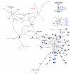
I have these two below, which I combined to create this live map [link] (still in progress). It's really interesting to have context of the old network and to see how it translates to the modern layout of our city. I'd love to know how the Victorians managed to navigate the complicated central network, as this is overlooked by the London underground-style diagram below.
Any information, maps, diagrams, or suggestions of where I could find information on the Birmingham Tram network would be greatly appreciated.
Chris, 26.
Attachments

Last edited:


