• Welcome to this forum . We are a worldwide group with a common interest in Birmingham and its history. While here, please follow a few simple rules. We ask that you respect other members, thank those who have helped you and please keep your contributions on-topic with the thread.

    We do hope you enjoy your visit. BHF Admin Team

Old Stechford, Yardley

MichaelW

New Member
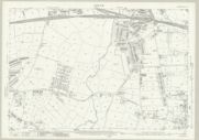
I have an ancestor who lived in Old Stechford, Station Road and on the 1911 Census, he was living at "Ivydale". His name was William Starkey.
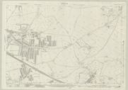
I'm uncertain whether there might be two properties in that area at that time called "Ivydale" but I know there are references to a Farm house called "Ivydale" which is on old maps of Yardley. Any information would be great.
 
Searching for 'Ivydale' on the 1911 census in Solihull (district) results in 2 households - that of your ancestor, William Starkey and that of Tom Ernest Weatherhogg (great name btw).

Tom Weatherhogg is listed as a farmer, grazier and general dealer with family and servants, including 2 grooms. There are also a number of mentions of him in Bham newspapers in the 1910s at Ivydale Farm, Yardley.

And in 1911 William Starkey seems to be listed at Ivydale, Northcote Road.
 
Last edited:
Looking at the old maps it appears that Northcote Road used to include what is now Old Station Road. The houses on Northcote Road proper seem to still be standing and don't appear to have been named (my 2 x g uncle lived at no 13) so I wonder if Ivydale was one of the properties (all gone) that would have subsequently been on Old Station Road.
 
If the numbering in Northcote Road has not changed then Ivydale was listed on the census next to number 2
1641221159195.png
there is still house number 2 which looks as it if would have been there in 1911. Very difficult to tell on old maps as Northcote road is on two sections and the split is where I think the house might have been.
1641221263095.png
 
Last edited:
I did wonder but it is difficult to tell as there are no names on the houses.
I did think they might have been listed first not last in that case.
 
Maybe if he they started at 1 got to the end of the odd numbers, did the even numbers back to 2, then went round the corner to the named houses.

No idea really, just speculating.
 
Just tried the eroll and on the 1920 eroll the cottages are listed after the odd numbers (after 35) and before the even numbers (starting at 36).

Yellow is 35 and green is 36 so could they be the buidings I have circled in red?
1641229430600.png
 
Last edited:
Sorry I'm a bit late here. Below is a map, part of one I downloaded from old maps before it expired. The numbering is not very clear but shows 35 in red, and 36 in blue, agreeing with Janice's suggestion.

map c1950s  showing 35 & 36 Northcote road.jpg
 
As I said at that time (1916 map) it looks to be part of Northcote Road, Station Road being parallel to the right. Not until the 1938 map is it listed as Old Station Road.

Not sure though and they could class both as Station Road.
 
Back
Top