-
Welcome to this forum . We are a worldwide group with a common interest in Birmingham and its history. While here, please follow a few simple rules. We ask that you respect other members, thank those who have helped you and please keep your contributions on-topic with the thread.
We do hope you enjoy your visit. BHF Admin Team
You are using an out of date browser. It may not display this or other websites correctly.
You should upgrade or use an alternative browser.
You should upgrade or use an alternative browser.
New Thomas Street
- Thread starter MikeP
- Start date
brummy-lad
master brummie
If we can have the names of your ancestors (and perhaps DOB) on the 1871 census I'm sure someone on BHF will be able to work it out.
MWS
from Bham
It seems to be in the sub district of St Peter so I'd guess it's Dale End.
Thomas St and John St ran parallel to each other between Dale End & Lichfield St. By 1891 (map) Corporation St had been laid out and there have been a lot of changes. I wonder if at some stage they were listed as 'New'.
You could check census scans for surrounding streets to give an area but maps of Bham around 1860 are rare.
hi mike as suggested can we have the name please that way we can hopefully identify the correct stI have an 1871 census of some ancestors living in New Thomas Street, looking at old maps I find this street illusive, is it the same street as Thomas Street or Upper Thomas Street or somewhere else. Any assistance would be appreciated.
lyn
Thank you all for the responses,
I am a keen family historian and this site has helped me enormously over the years helping me to find streets and street numbers along with photo's.
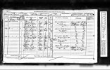
The attached 1871 census details 'New Thomas Street', my ancestors are the first family of Jones's. I suspect the NEW got dropped, only being used for a short period but is it Thomas Street or Upper Thomas Street or some other street. Searching on this site and on line generally I have not seen any reference to New Thomas Street anywhere.....Yet.
Once I have found the right street, I then I like to see if I can find the house and further if there are any Arial or general photo's.
Thank you for your assistance
I am a keen family historian and this site has helped me enormously over the years helping me to find streets and street numbers along with photo's.
The attached 1871 census details 'New Thomas Street', my ancestors are the first family of Jones's. I suspect the NEW got dropped, only being used for a short period but is it Thomas Street or Upper Thomas Street or some other street. Searching on this site and on line generally I have not seen any reference to New Thomas Street anywhere.....Yet.
Once I have found the right street, I then I like to see if I can find the house and further if there are any Arial or general photo's.
Thank you for your assistance
Attachments

Very much appreciated thank you, that is amazing and no where near where I thought it would be, but there is a sad little tale to this too.
In the census record I posted the first Jones family are my G. G. Grandparents. The wife of Thomas, Sarah Jones nee Gwyther, perished in a fire in Doe Street, bottom of New Thomas Street in 1899. It makes that image even more interesting to me. Thank you
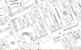
yes i agree mike..you most likely know of the scottish map site but just in case link is below...move to blue dot to see what is there today..just going to make a cuppa and i will search my files for any photos of the streets you are interested inLooks like New Thomas Street turned in the Gem Street; all long gone now, buried under Aston University
lyn
Yes, the Scottish map site is very good and I have been trying to collect old maps beyond that, but you guys on here have a whole lot I don't have and is has been so helpful.yes i agree mike..you most likely know of the scottish map site but just in case link is below...move to blue dot to see what is there today..just going to make a cuppa and i will search my files for any photos of the streets you are interested in
lyn
Back in the day families in Birmingham all lived very close, my Grandmother and some of her siblings was born in Coleshill Street to the son of the aforementioned Thomas and Sarah, so the map you sent is very pertinent to me.
Hi MWS, a few days ago you kindly posted this map showing New Thomas Street (later Gem Street) which I was struggling to find. It all made sense in the end (as to where it was) as my grandmother was born in Coleshill Street and her grandparents lived in New Thomas Street then Doe street.
My G.G grandparents lived at No 1 front New Thomas Street. I took some advice of a member on here and looked at the previous record which was in Lawrence street through New Thomas Street to Coleshill street implying the that number 1 was the opposite end to Coleshill Street.
The census records have house numbers 1 - 30 plus all the 'back of' residence. But the maps I have don't have 30 houses in the short section of New Thomas Street so I was wondering if, at least initially, the houses in Gem Street were included?
Thomas Street finishes at Vauxhall street in your map, I have since seen a circa 1876 map showing New Thomas Street continuation into Gem Street but makes me wonder if that too (Gem Street) was at least called New Thomas Street initially.
mikejee posted a map showing house numbers on a later map (attached) with numbers up to 71, so that that isn't right.
To save me rambling any more, do you have and will you share with me the part of the map above Vauxall Street, was there a road there? The church is missing at the end of Vauxhall street so perhaps gem street wasn't built then, or may be some of it was.
Any assistance would be appreciated, I will be posting some of the above to mikejee in another forum to see if he can shed any light on it. I have some arial photos I have identified of the street and would love to know where No 1 was.
Mike
Attachments
MWS
from Bham
No problem. Below is a larger section, though both roads end at the point they meet,
The map is quite a small scale so I see no real problem that there are 30 front houses, probably a few more on the west than the east. Also this map is from 1839, so there may have been some changes.

The map is quite a small scale so I see no real problem that there are 30 front houses, probably a few more on the west than the east. Also this map is from 1839, so there may have been some changes.
If one looks at the Post office directory for 1872 and Whites directory of 1873, in the former New thomas St is listed, and in the latter , against this it is stated "Now Gem St". The numbering appears to be unchanged , but the street is longer than that in the 1839 map you have seen. The map for the mid 1880s is below, and shows it going up to join Aston st. The numbering is consecutive (1,2,3,4...) and Lawrence st is between 14 and 16. therefore no one must be the first numbered house at the north end on the eastern side. Therencould have been demolitions and rebuilding between 1871 and the mid 1880s, but if not then the large building on the corner is likely to have been listed in Aston St, so no1 will be the building in red
