-
Welcome to this forum . We are a worldwide group with a common interest in Birmingham and its history. While here, please follow a few simple rules. We ask that you respect other members, thank those who have helped you and please keep your contributions on-topic with the thread.
We do hope you enjoy your visit. BHF Admin Team
You are using an out of date browser. It may not display this or other websites correctly.
You should upgrade or use an alternative browser.
You should upgrade or use an alternative browser.
Moseley Road
- Thread starter Paul D
- Start date
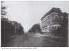
Moseley Road looking towards the swimming baths/library on the left. To the left is Edwards Road.
A few recognisable landmarks still there including the print works building in the distance on the right (striped brickwork). The church on the right has gone as have some of the shops. Viv.

A few recognisable landmarks still there including the print works building in the distance on the right (striped brickwork). The church on the right has gone as have some of the shops. Viv.
Phil
Gone, but not forgotten.
Viv
Those two photo's were taken quite a distance apart, the older one of the two was taken from between Brighton Rd and Runcorn Rd just short of the Congregational Church that stood there until t burnt down in the 50's. The newer one of the two was taken just past Clifton Rd outside where the Imperial Cinema once stood. Viv the snip from Google that I am attaching is more representative of the spot, and the only reason I know Viv is because the area was my back yard for a good portion of my life.
Those two photo's were taken quite a distance apart, the older one of the two was taken from between Brighton Rd and Runcorn Rd just short of the Congregational Church that stood there until t burnt down in the 50's. The newer one of the two was taken just past Clifton Rd outside where the Imperial Cinema once stood. Viv the snip from Google that I am attaching is more representative of the spot, and the only reason I know Viv is because the area was my back yard for a good portion of my life.
Attachments
Thanks Phil. Viv.
Hi viv
Nice pictures of the yester years and what a transformation of the road from them days
Through up and till now ,I do travel from time to time along that road from time to time
I recall going to the swimming baths but also going down mosely road and through the back streets
Going to cannon hill park during the fifty,s then during the seventy and eighty period of years
I used to reposess house around that area and worked from various estate agents
Right in the Heart of Moseley village I used to court a young lady
Whom lived in terrace right by the number eight bus stop on Balgrave road then they moved to Gladstone road
Aston off church lane where upon she died sadly
As I said in those days mosely road was classed as balsall heath then years later it was a boundary change to call KT Moseley, and guess what the council now want to change it back to balsall Heath Again
What a crazy council we have in brum ,best wishes Alan,, Astonian,
Phil
Gone, but not forgotten.
Astonian
I don't think any part of Moseley Rd has ever been classed as Moseley. It starts at Bradford St which was known as Balsall Heath before it became Highgate and it runs through Balsall Heath to Trafalgar Rd just before the boundary of Moseley where it becomes Alcester Road on its way through Moseley & Kings Heath where it becomes Alcester Road South.
I don't think any part of Moseley Rd has ever been classed as Moseley. It starts at Bradford St which was known as Balsall Heath before it became Highgate and it runs through Balsall Heath to Trafalgar Rd just before the boundary of Moseley where it becomes Alcester Road on its way through Moseley & Kings Heath where it becomes Alcester Road South.
In the fiftys on mosely road just passing belgrave road junction traffic lights
Coming from the city heading towards mosely village and shortly passing the mosely road
Picture house which was on mosely road approximently 200 yards from the picture house
Hanging high for all to see in the mid fifths was the sign Balsall heath also it hung on the begging
Of the pershore road stating balsall heath it was just before the city change there boundaries
To new boundaries then it was classed as mosely all the way to the village hence Moseley village
And now they have decided to reverttheboundries back to balsall heath shortly
Or they have recently decided but today people of mosely are objecting they call it back as Balsall heath
Astonian, Alan,,,,
Phil
Gone, but not forgotten.
Alan
I can't ever remember the boundary between Moseley & Balsall Heath on the Moseley Rd moving more than a couple of yards and that was probably only due to the actual sign by Trafalgar Road being moved. These three maps show the boundaries of Balsall Heath from before the last war. Map one shows the boundary line in red, map 2 shows it in blue and map 3 in red again., On none of the maps does the boundary line on Moseley road extend past Trafalgar Road and therefore include Alcester Rd.
I can't ever remember the boundary between Moseley & Balsall Heath on the Moseley Rd moving more than a couple of yards and that was probably only due to the actual sign by Trafalgar Road being moved. These three maps show the boundaries of Balsall Heath from before the last war. Map one shows the boundary line in red, map 2 shows it in blue and map 3 in red again., On none of the maps does the boundary line on Moseley road extend past Trafalgar Road and therefore include Alcester Rd.
Attachments
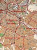

Although the first map does show Balsall Heath, the other two show Birmingham 12 which is not really the same thing. I'm not sure when they started with the numbered rather than named areas (1920s/30s) but, somehow, I doubt they exactly matched the named districts. As far as I can tell Balsall Heath never went much beyond the Belgrave Road but B12 goes all the way to Digbeth.
Phil
Gone, but not forgotten.
If you look at the map you will see that all three are marked Balsall Heath, yes the northern border of Balsall Heath has changed over the years if you look at my earlier post you will see that I stated as much. The point being made here concerns the southern end of Moseley Road and it's boundary with Moseley & Balsall Heath. It is easily discernible that it hasn't moved much since the first pre-war map was made.
Phil
Gone, but not forgotten.
True, all 3 have Balsall Heath printed on the map somewhere but the later 2 have a border in style and colour that matches the number 12 printed large and within the area. That's why I say that the bordered area relates to Birmingham 12 rather than Balsall Heath.
All of Balsall Heath has been included in Birmingham 12 ever since I was born in 1947, in that time I have never known the boundary between Moseley & Balsall Heath on the Moseley Road change. I posted these maps to demonstrate that fact. It matters not a jot about the rest of the map and where the boundary is, this question just concerns the boundary between Moseley and Balsall Heath on the Moseley Road or are you disputing the boundary is where the maps place it? If so I would like very much to see your evidence as it would be new to me.
john knight
signman
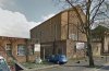
I was at the Art School 1952-55,church is still there and school is owned by Indians, who let me have a free wander round a few months ago, strange to see the classrooms after all this time.Moseley School of art was across from the baths now a mosque or some such. The church that was next to the school was bombed out during WW2 I was a student at the school last two years of WW2 we joked that gerry should have bombed the school not church
Phil
Gone, but not forgotten.
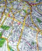
Old Brit do you mean the Wesleyan Methodist Church next to the Art school on the other side of Lime Grove that was replaced by the building in the second photo and is now something to do with the Muslim community?
Attachments
oldbrit
OldBrit in Exile
I am not sure this was a long time ago But I do remember towards the end of the war going to school on the bus one day and seeing that the church. that WAS next to the school was in ruins. Someone also said that a man died in the church when it was hit.Last year on a visit we drove past the school which now loos like a muslin building and the church there now is now the same of the one that was thereOld Brit do you mean the Wesleyan Methodist Church next to the Art school on the other side of Lime Grove that was replaced by the building in the second photo and is now something to do with the Muslim community?
B12 is Balsall Heath & Highgate although B12 8** and B12 9** roughly correspond to the Balsall Heath Council District of the late 50s/early 60s. I know the council district is older than that but they sliced off the bit between Balsall Heath Rd and Belgrave Rd in the 50s and abolished the district in the 60s and that's the version that matches those postcodes closest. The churches of St. Paul's and St. Barnabas' usually supply the names for the parishes within Balsall Heath which implies it wouldn't have been well defined on the parish map. The name seems to go back further than those particular parishes as it is usually said to have derived from the Saxon. I doubt that boundaries would be well defined for most of the time although there does seem to be a consensus that the river Rea formed part of the boundary.