• Welcome to this forum . We are a worldwide group with a common interest in Birmingham and its history. While here, please follow a few simple rules. We ask that you respect other members, thank those who have helped you and please keep your contributions on-topic with the thread.

    We do hope you enjoy your visit. BHF Admin Team

Mary Anne St and Bartholomew ST

ellie

master brummie
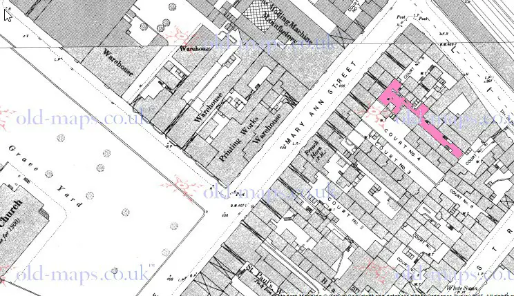
Looking for 1 streets where a rellie's was living in 1844. It is 5 Court Mary Anne Street.

The family appeared to move around a bit. However they appeared to stay in the same area as in Digby Street ( several differnt numbers, Legge St, Moland Street)

The other street is where the grandfather lived in 1816 and it is Bartholomew St.

Were my relatives bad rent payers or did people move frequently?
 
I have altered the text when reposting the map. Before I was not sure which was court 5 , but as I am now certain which is court 5 I have marked it in red.


map_c_1889_Mary_ann_st_showing_court_5_.jpg
 
Elllie
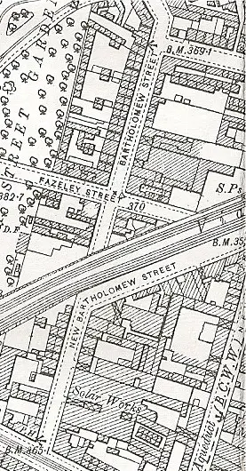
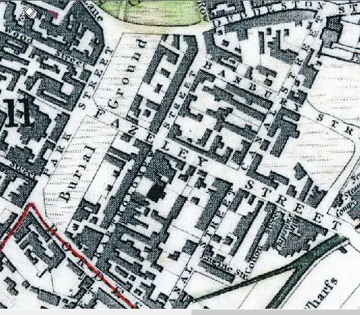
Attached is a map showing Bartholomew st in 1839, crossing Fazeley st down to Bordesley st . There is also a map c 1910 in greater detail. Here part of the old Bartholomew st is a part of New Bartholomew st., but in 1816 I assume the street would have been as the 1839 map.

map_bartholemew_st__c1910.jpg


map_c_1839_showing_bartholemew_st.jpg
 
Once again you have come though Mike. Thank you.

Do you know where I could purchase or download a map that I could use to plot the homes of different movements and homes of family members? I would like to use different colours to represent each member.

My latest lead is Richard Cooper living at 14 Barn Street in 1891 and at 752 Coventry Road in 1901.
 
Dib
On the map of 1839 I put on, there is a patch of green to the top. this is the grounds of St Bartholemews chapel. Going up on the right of the grounds is a road where you can just read "Row". That is Bartholemew Row.
Ellie
The mapseeker website has maps of birmingham of various ages. you can download sections and stick them together, or you can purchase whole maps from the site
mike
 
Ellie
Attached are two maps, the second is showing Barn st in 1890 with what I think is no 14 in red. Its certainly that house or one either side. The first shows 752 Coventry road (definitely no argument) in red in 1903. The dotted road to the left is mansel rd. the space in the houses to the right of this will become Aubrey rd, and the second space , the other side of the marked house, will become St Benedict's road.
mike
 
Elllie
Attached is a map showing Bartholemew st in 1839, crossing Fazeley st down to Bordesley st . There is also a map c 1910 in greater detail. Here part of the old Bartholemew st is a part of New Bartholemew st., but in 1816 I assume the street would have been as the 1839 map
Mike

This is very interesting. Thanks particularly for posting the 1839 map image - as a matter of interest, what map is this little gem from? (The 1910 image I recognise as being from the Godfrey map of the area.)

Some of my HEWSON ancestors lived at 87 Bartholomew street in the 1840s, certainly as late as 1847 when my g-g'father was born. I wonder if anyone knows where that house would have been? By 1851 they'd moved to Bath St. I guess there was considerable disruption when the railway line to New St. was built, dividing the original street into two.
 
The 1839 map is a redrawn version of the map published (in 1839) by the Society for the Diffusion of Useful Knowledge in the united kingdom
I can't be very helpful with where no 87 is. All the numbering in bartholemew St after its splitting into the new and old streets changed.and at present i can't say what the old numbering was.
mike
 
Back
Top