-
Welcome to this forum . We are a worldwide group with a common interest in Birmingham and its history. While here, please follow a few simple rules. We ask that you respect other members, thank those who have helped you and please keep your contributions on-topic with the thread.
We do hope you enjoy your visit. BHF Admin Team
You are using an out of date browser. It may not display this or other websites correctly.
You should upgrade or use an alternative browser.
You should upgrade or use an alternative browser.
Islington Row
- Thread starter Astoness
- Start date
hi lynn;
many thanks first of all for putting that picture up ;i also find it very intresting i do remember islington row from the old days
and i would very much like to know myself wht was the arches ; i think those chimmney stacks could have been
from the old BSA armoury in the distance i know davenports was around in the early years so it could have been bath row
i think our best man for these questions would be mike may be he can shedd light on this pic ; if we give him time ;
lynn ; thanks again a nice bit of detection and tracking on this islington row i can recall the early forties onwards but that is just short of mymemo.s
have a nice day lynn alan ;;
Lyn
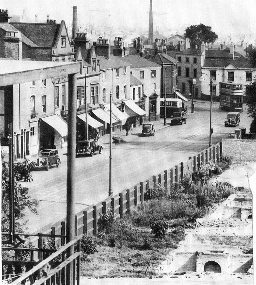
The picture is Islington row to the west of the junction with Bath row and william St. It is william St that the bus is coming out of. the building just in front of that is the White Swan. the area with the arches I am pretty sure is the same (about) as that marked in red. In this and maps of the 1920s and c 1938 the buildings seem to be approx the same. however by 1953 the area is covered by a day nusery, so I would suggest that it got bombed and the arches are part of underground cellars. These buildings seem to be private houses.
Mike
TOPSYTURVEY
brum
1957

www.midlandspubs.co.uk
Pub Historian
Yes, definitely cellars of houses, many of which were rather elegant and grand. At one time, they were mainly occupied by medical professionals, probably those working at the Children's Hospital.
I have done a bit today on this street. I got diverted once again from the Villa Tavern : https://www.midlandspubs.co.uk/birmingham/islington-row/
Cheers, Kieron
I have done a bit today on this street. I got diverted once again from the Villa Tavern : https://www.midlandspubs.co.uk/birmingham/islington-row/
Cheers, Kieron
Williamstreeter
master brummie
Mike I used to live in William St 1955-69 , although you have the plans I would say that is too far down for William St . Looks more like an entrance to Communication Row . I do realise this pic is years before I lived there but its still looks too far down to me
Williamstreeter
master brummie
Yes, definitely cellars of houses, many of which were rather elegant and grand. At one time, they were mainly occupied by medical professionals, probably those working at the Children's Hospital.
I have done a bit today on this street. I got diverted once again from the Villa Tavern : https://www.midlandspubs.co.uk/birmingham/islington-row/
Cheers, Kieron
Kieron the pub in the pic is on the corner of Tennant St and Islington Row in your link
www.midlandspubs.co.uk
Pub Historian
Kieron the pub in the pic is on the corner of Tennant St and Islington Row in your link
I'm confused by your message Williamstreeter. Are you referring to the pic in Post #1 from Lyn? That is the White Swan. The pub on the corner of Tennant Street was the Anchor Inn.
Williamstreeter
master brummie
I'm confused by your message Williamstreeter. Are you referring to the pic in Post #1 from Lyn? That is the White Swan. The pub on the corner of Tennant Street was the Anchor Inn.
Forget what I said , I've studied your post better now


Islington Row c1920 compared with modern-day Islington Row Middleway. The clock now moved to the green space nearby between Harborne Road and Calthorpe Road.


