• Welcome to this forum . We are a worldwide group with a common interest in Birmingham and its history. While here, please follow a few simple rules. We ask that you respect other members, thank those who have helped you and please keep your contributions on-topic with the thread.

    We do hope you enjoy your visit. BHF Admin Team

Grantham Rd Sparkbrook bombings.

Tip; always search before posting.
Try here
 
Thank you. My mother lived at 95 Grantham Rd during the war with 14other people so the houses must have been very large Victorian houses. Does anyone know when these houses were war damaged or demolished?
 
I lived in the adjacent Dolobran Road from my birth in 1945 until I got married in 1965 so I have relatively good memories of the 50s and early 60s. I can't recall any war damaged property although there were newish flats and maisonettes at the start of Grantham Road from the corner of Farm Road. These could have replaced war damaged properties. The houses in Grantham Road were large properties and throughout the 50s became multi occupied by the heavy influx of Irish folk into the district, particularly those properties between the junction of Hickman Road and the joining of Palmerston Road on both sides of Grantham Road. Of particular interest in Grantham road were the parish C of E church, Christ Church on the corner of Grantham Road and Do!obran Road and Dr Lucy's surgery on the corner of Grantham Road and Anderton Road.
 
Thank you for that information Clive.
I was born in 1945 but only lived in Grantham Rd for about 6months before we were moved elsewhere. I just wondered what had happened to those large houses.
 
Thank you for that information Clive.
I was born in 1945 but only lived in Grantham Rd for about 6months before we were moved elsewhere. I just wondered what had happened to those large houses.


as already said a lot of old victorian houses were divided into multiple occupancy hence you say 15 others living there..no 99 along with other houses in grantham road did suffer bomb damage with some injuries so it is likely that no 95 could also have been damaged and so demolished...difficult to say exactly when they were demolished..here is a list of those injured

Last Name Forename(s) Date of Injury Location of Injury Age Civil Defence Status
Allwood Elsie Elizabeth 11/12/1940 3, Grantham Road, Sparkbrook 48 Civilian View
Bevan William Thomas 11/12/1940 3 Grantham Road, Sparkbrook Civilian View
Crinnian Edward Joseph 11/12/1940 1 Grantham Road, Sparkbrook Civilian View
Everitt William Ernest 11/12/1940 3 Grantham Road, Sparkbrook 42 Civilian View
Holcroft Edward 20/11/1940 99 Grantham Road, Sparkbrook Civilian View
Kelly E (Mrs) 26/10/1940 27 Grantham Road, Sparkbrook Civilian View
McCluskey John 20/11/1940 99 Grantham Road, Sparkbrook Civilian View
Simpson Elizabeth Rose Edith 11/12/1940 3 Grantham Road, Sparkbrook 44 Civilian View


list of those killed at no 3..note all different surnames so again no 3 was most a shared occupancy property

Last Name Forename(s) Date of Injury Location of Injury Age Civil Defence Status
Allwood Elsie Elizabeth 11/12/1940 3, Grantham Road, Sparkbrook 48 Civilian View
Everitt William Ernest 11/12/1940 3 Grantham Road, Sparkbrook 42 Civilian View
Simpson Elizabeth Rose Edith 11/12/1940 3 Grantham Road, Sparkbrook 44 Civilian Vie
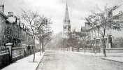
 
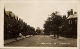
having given you the info above of bomb damage the numbers only go up to no 73 now and in 1963 some houses were under compulsory purchase so maybe this included no 95...here is a street view showing no 73 then after that you will see a fence with trees behind...this is where numbers 75 to at least no 99 once stood...also attaching a short news video about the compulsory purchase of some houses. in 1963.if you look closely you can see the number 77 on the gate of one of the houses...so apart from bomb damage this could be another reason that some houses were demolished after 1963..hope this helps as i think its the best we are going to do..but here are a couple of old photos showing what the road was likeSparkbrook Grantham Rd looking towards Farm Rd .jpgSparkbrook Grantham 1915.jpg

lyn


Last edited:
1962 and 1965 erolls for Grantham Road (can't check later as they are not on Ancestry) don't have any voters registered at 95. It jumps from 91 to 99 - does this suggest houses were empty?
 
I worked in and around Grantham Road in the early 80’s in the construction industry. There were a lot of signs of bomb damage then. The odd gaps in the older houses filled in with post war construction. There was also quite a lot of war glass in some of the older property’s too.

Quiet a lot of the local residents would tell be stories of the WWII bombing raids including one chap who was a warden who attended the bombing of the BSA on the actual night.
 
Back
Top