Grizzlesmethwick
New Member
Hi all - just for accuracy, would you class George Street West as Hockley, Ladywood, Winson Green, somewhere else? Or is Spring Hill an entity in its own right? Grateful for any input.
Cheers.
Cheers.

Thanks for that, I guess I was looking for people's opinions rather than the internet, but thanks for the input. Interestingly, a different website suggests Hockley:
George St west was always in 'Brookfields' until the redevelopment of the area in the 70's. No idea what area it is now.Hi all - just for accuracy, would you class George Street West as Hockley, Ladywood, Winson Green, somewhere else? Or is Spring Hill an entity in its own right? Grateful for any input.
Cheers.
I have ALL SAINTS on my birth certificate.Bob my brother born 9th October 1947 in Coralie st, which was one street a both George St West off Prescott St on his birth certificate it says Sub- District of ALL SAINTS. On my certificate 6th May 1952 it says the same. yet I call my self a Hockley lad, some times say Brookfields lad.
Was classed as spring hill when i lived there. The part i lived in has been demolished, along with the rec and my school. Only the top bit by the church remains nowHi all - just for accuracy, would you class George Street West as Hockley, Ladywood, Winson Green, somewhere else? Or is Spring Hill an entity in its own right? Grateful for any input.
Cheers.
Also was known as brookfieldsWas classed as spring hill when i lived there. The part i lived in has been demolished, along with the rec and my school. Only the top bit by the church remains now
George Street West, it was Hockley. I lived in Coralie St which was one street above that was also Hockley.Hi all - just for accuracy, would you class George Street West as Hockley, Ladywood, Winson Green, somewhere else? Or is Spring Hill an entity in its own right? Grateful for any input.
Cheers.
Hi Nick, I am no expert either, and I don't wish to prove you wrong, because you are not wrong, and your opinion is valued. I said "loosely" because I was only speculating. Sometimes one area can be seen as part of another if it is cut off from its main part by a railway, motorway, river etc, and sees itself as part of its neighbor due to ease of access. Also, I looked at an old map, so City Fever Hospital may not be familiar to you. I hesitated to include the area south of Spring Hill, but it is cut off to the south by the canal, and may have been seen as part of Brookfields by its residents. Who knows? But to give a revised suggestion, and only a suggestion, consider these boundaries: Western Road in the west, or, the canal in the west (the residents between Western Road and the canal may or may not have considered themselves part of Brookfields), in the northwest,, the little corner occupied by Brookfield Road, in the north, the Hockley goods yard and Pitsford Street, in the east, Icknield Street, and in the south, Springhill.ER Allen, I'm no expert. Not sure where City Fever Hospital is. At a guess I would have thought it would be a part of City hospital which when I was a lad was Dudley Rd hospital. Next to the Hospital on Western Rd in the 50's / 60's was the work house.
I do remember a number of years ago I was outside the library someone asked me where city hospital was? told them I had no idea I knew where Dudley Road hospital is.
Cope St, in my opinion its the wrong side of Spring hill to be a part of Brookfields but you may prove me wrong.
Nick S Phillips
Hi Nick, I am no expert either, and I don't wish to prove you wrong, because you are not wrong, and your opinion is valued. I said "loosely" because I was only speculating. Sometimes one area can be seen as part of another if it is cut off from its main part by a railway, motorway, river etc, and sees itself as part of its neighbor due to ease of access. Also, I looked at an old map, so City Fever Hospital may not be familiar to you. I hesitated to include the area south of Spring Hill, but it is cut off to the south by the canal, and may have been seen as part of Brookfields by its residents. Who knows? But to give a revised suggestion, and only a suggestion, consider these boundaries: Western Road in the west, or, the canal in the west (the residents between Western Road and the canal may or may not have considered themselves part of Brookfields), in the northwest,, the little corner occupied by Brookfield Road, in the north, the Hockley goods yard and Pitsford Street, in the east, Icknield Street, and in the south, Springhill.
The area encompassing Eyre Street in the west, Springhill in the north, Icknield Street in the east, and Cope Street and the Canal in the south, one would have to ask, what district is this officially, and what do the residents of this area consider themselves to be part of? As a non-resident, I cannot pronounce, only guess. If anyone reading this was a resident of either of these areas, their opinion would be most welcome.
I am looking at an old Staffordshire map, circa 1890. The area west of the Birmingham Canal, below Lodge Road is the "Borough Fever Hospital", and just below the canal is "Borough Smallpox Hospital". South of this, straddling Western Road, is the "Workhouse". Further south, between the canal and Western Road is "Spring Hill Boiler & Engine Works". Springhill Street appears to be the southern boundary of Brookfields,, and east of Icknield Street, it is called "St Paul's". Presumably "Hockley Goods Yard" and "Hockley Station" are part of Hockley, and would be the northern boundary of Brookfields.ER Allen, I still consider myself to be a Hockley / Brookfields kid.
I've never heard of the "City Fever Hospital" .But looking at an old A-Z " cost 6/-" it was on Lodge Rd next door to City Mental Hospital, which we called "The mad House" Winson Green Prison next door on Winson Green Rd.
I was surprised that Eyre St / Cope St and Steward St are so close to where I grew up.
Its an area when I was a lad that I never strayed into.
Nick S Phillips.
Bob my brother born 9th October 1947 in Coralie st, which was one street a both George St West off Prescott St on his birth certificate it says Sub- District of ALL SAINTS. On my certificate 6th May 1952 it says the same. yet I call my self a Hockley lad, some times say Brookfields lad.
HOBRO_SAINT?Well, if you're from Hockley, Brookfields, and All Saints, then logically, HOckley + BROokfields + all SAINTs, are you a HOBRO-SAINT?
i think it means HO for hockley BRO for brookfields and SAINT for all saintsHOBRO_SAINT?
You have lost me on this one.
Nick Phillips
") very clever
very cleverLyn, many thanks.i think it means HO for hockley BRO for brookfields and SAINT for all saints
lyn
hi nick..its just a spin of words on the 3 areasLyn, many thanks.
My grammar at times is questionable, But HOBRO-SAINT?
Nick
ER Allen, I still consider myself to be a Hockley / Brookfields kid.
I've never heard of the "City Fever Hospital" .But looking at an old A-Z " cost 6/-" it was on Lodge Rd next door to City Mental Hospital, which we called "The mad House" Winson Green Prison next door on Winson Green Rd.
I was surprised that Eyre St / Cope St and Steward St are so close to where I grew up.
Its an area when I was a lad that I never strayed into.
Nick S Phillips.
I found another item on this area. My map shows a workhouse, which was the new Birmingham workhouse, opened in 1852, located in Western Road. Has been demolished, and the land used as a car park for Dudley Road Hospital, now renamed City Hospital.ER Allen, I still consider myself to be a Hockley / Brookfields kid.
I've never heard of the "City Fever Hospital" .But looking at an old A-Z " cost 6/-" it was on Lodge Rd next door to City Mental Hospital, which we called "The mad House" Winson Green Prison next door on Winson Green Rd.
I was surprised that Eyre St / Cope St and Steward St are so close to where I grew up.
Its an area when I was a lad that I never strayed into.
Nick S Phillips.

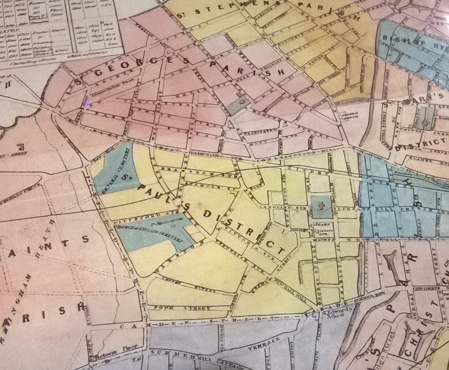
ER Allen, great map, wish I had a copy. Wonder how old it is?I found this map, but is uncredited, so am unsure of source, or year of publication. To the east of Icknield Street, one sees St Paul's Parish, and the area known Brookfields shows as All Saint's Parish. Almost nothing in Brookfields at this point, it is part of Birmingham Heath.
I am guessing 1850-60.ER Allen, great map, wish I had a copy. Wonder how old it is?
Thank you
Nick Phillips
I was wavering between 40s 50s and 60s...Difficult to tell, but I would say 1840s.