• Welcome to this forum . We are a worldwide group with a common interest in Birmingham and its history. While here, please follow a few simple rules. We ask that you respect other members, thank those who have helped you and please keep your contributions on-topic with the thread.

    We do hope you enjoy your visit. BHF Admin Team

Factory Road - 1854?

BevanSeeker

New Member
Hi,
Looking for information on where exactly Factory Road is 1854. I am researching family history and have a birth with a location listing of 'Foster's Building' Factory Road Birmingham in 1854. I haven't trawled the old maps yet but wondered if anyone had a idea of whereabouts in Birmingham this would have been.
Looking for the social history of this area and what Foster's building was.
 
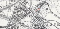
hi and welcome..only a guess but would think fosters building was just the name of block of a few houses..not sure the name would be marked out on a map that old but hopefully someone can help..here is a map showing where factory road is now and i would think it was the same back in 1854..if you move the blue dot the map fades out to show you what is there now..you can also move the map around to see surrounding area..hope this helps

lyn

 
Can you give a name ? We can then look further into the adjacent address.
Looking 1850-1900 there is a Foster’s Buildings in Park Road Hockley, which is close to the Factory Road, Soho.
 
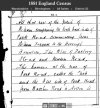
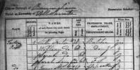
A couple of items to get the thread started. Factory Road is on the 1851 census also but does not appear to mention 'Foster's Building'.
 

Attachments

  • factory-road-map-1892-1914.jpg
    factory-road-map-1892-1914.jpg
    1.1 MB · Views: 3
  • 1881-census-factory-road.jpg
    1881-census-factory-road.jpg
    325.7 KB · Views: 3
Last edited:
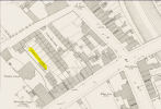
i thought i had seen an enquiry some time ago for a building in factory road so went back on old threads and found this one...asking where a powells building factory road was in 1853 that was on a death cert...on the thread janice posted this map showing powells buildings and dyers buildings next to it that was in benson road a continuation of factory road (maybe back then benson road was known as factory road ) ..just wondering if our fosters building was nearby (maybe we could see an extension of janices map)..also link to thread below...

maybe bevanseeker could post us the 1854 birth cert to look at so that we can see the name on it


I have checked the map and can see no other named "buildings"
 
Back
Top