• Welcome to this forum . We are a worldwide group with a common interest in Birmingham and its history. While here, please follow a few simple rules. We ask that you respect other members, thank those who have helped you and please keep your contributions on-topic with the thread.

    We do hope you enjoy your visit. BHF Admin Team

Does anyone have a detailed map of Gooch St?

BordesleyExile

master brummie
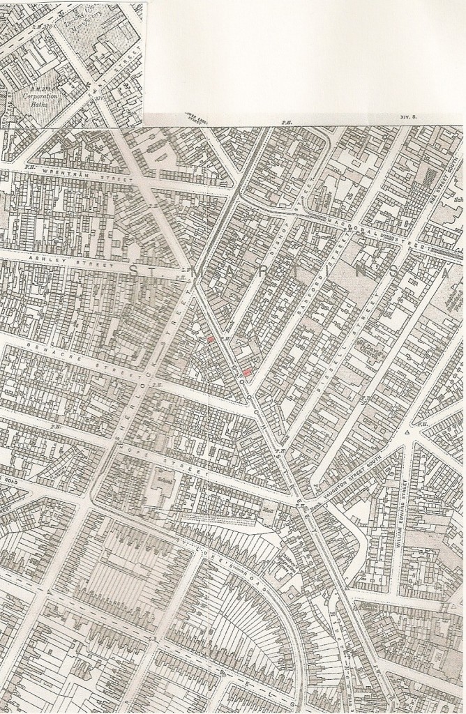
Does anyone have a detailed map of Gooch St showing individual buildings in approximately 1891-1901 or close years? I want to anchor 145, which was on the corner of Vaughan St Sth & also 178-180 which was close to Bishop St Sth on the stretch between Bishop St & Bissell St.
There is a romantic story here. My Great Grandmother Lizzie Wiggins, whose father Joseph ran a grocer's shop at 145, met my Great Grandfather William Fleetwood when he lived at 178-180. They went on to have 9 children.
180 was, at one time, the Duke of Wellington, so I am unclear whether 178-180 was merged at some point or perhaps the top floors were let as individual dwellings while drinking went on below.
 
Here's a map of gooch st made up mainly from c1913 map. with the top end c 1910. I have marked what i think are nos 145 (on left side) , and 178-80 (right side), in red.
.
mike


gooch_st_c_1910.jpg
 
Last edited:
Mike I might have known it would be you who would deliver. Thank you very much for helping to build up the picture of the locations. I have saved & also emailed with attachments so you can delete the map whenever you like.
 
Mike,

That looks like a very detailed map and I wonder if you can help me with a similar map scan of Sparkbrook. I grew up at 58 Leamington Road, between Ladypool Road & Stoney Lane, B12, and later at 2/66 but I can't pinpoint our old house on a modern map or on the ground as the whole street has gone and is now the site of the Nelson Mandela School.

I'd be very grateful of any help.:)

Graham.
 
Only too glad to help, Graham. You asked for Leamington road, but I thought you might be interested in a larger area, so have included the whole of Ladypool Road. They're taken from the 1913 maps. As with the other map, I'll leave on for a week and then remove ,as they are both almost 1 Mb.
Am i correct in deducing that the two groups of houses at the back of the northern side of Leamington Road are , from the left , Patshull Place and Grafton Grove ? It's good to have these things confirmed, as , now, they only appear in directories as short entries with it not being clear exactly where they are.
mike
 
Last edited:
Am i correct in deducing that the two groups of houses at the back of the northern side of Leamington Road are , from the left , Patshull Place and Grafton Grove ? It's good to have these things confirmed, as , now, they only appear in directories as short entries with it not being clear exactly where they are.
mike

Mike,

Thanks a million for that!

Yes you are quite right, we lived at 3/66 Leamington Road and that was really N° 3 Grafton Grove, we moved to N° 2 when I was about 13 years old in 1957. On your map I've marked Grafton Grove and N° 2 in red.

Graham.
 
Thanks Mike and Rod, it works just like you say now if i can just work out where 25/27 were. Visted Bishop Street last August, virtually all the victoria buildings now gone and just waste land.

Helen
 
Hi Mike Jee,
Have you taken the map of Ladypool Road off the site yet, I grew up in St.Pauls Road,(I was born in 1930), went to Clifton Road Infants & Junior Schools,until 1940,
when I was evacuated to Cheltenham,until we came back in 1944, & was at Dennis Road School From Xmas 1943for 6 months, Then started work at 14 years old.
So I remember the area well.
Barney Martin
 
Dear Mike

The map you have posted of Gooch street is great as it includes Bishop Street where my ancestors lived and had a factory. Trouble is the bit of the street where they lived is missing. (The top bit) They lived and worked at nos 25+27. Maybe that bit of Bishop Street is missing from the maps altogether? But if you have that bit available any chance you could post it for me?

Many thanks
Hlen
 
Helen
All of birmingham that wasn't countryside around 1900 is available on alan godfrey maps, and much that was countryside. It being Sod's law, as my grandfather would have put it, whenever you want a road there's a great chance it is crossing the border of one of the sheets. Anyway here is the whole of bishop st around 1901. The two maps its on say 1913 and 1902-11, but each one of these has had several revisions, so c 1910 is as good as you'll get !
Again I've put it on a link

https://i431.photobucket.com/albums/qq38/jeemikejee/mapc1910bishopst.jpg

Mike
 
Mike you are a star!!

Can you tell me which maps you used, if they are freely available I would like to get copies. My Woodyatt branch lived in Bishop Street and my Grandmother was born there. However, her father lived "round the corner" so having my own copies of the maps would be useful, if only 'cos then I wouldn't be bothering you all the time.

Thanks so much
Helen
 
Helen
Ones for an area are often available in local bookshops, but the easiest way (and i think the cheapest, as they are relatively reasonable, and as sometimes bookshops add on a bit) is from the website (£2.25 + 0.75 for total postage, any no of maps)
https://www.alangodfreymaps.co.uk/acatalog/Warwickshire__Birmingham_area_.html
This is direct to the birmingham/warwickshire part and you just scroll down. The 2 I used for yout map are:Warwickshire 14.09 (Birmingham south 1913) and Warwickshire 14.05 (Central Birmingham 1902-11).
mike
 
Thanks Mike.

I was at the Oxon and Buck Family History Fair yesterday where there were several stalls there selling Alan Godfry maps. I hadn't bought them in the past 'cos I was never sure which ones covered the areas of Brum I wanted but now I know I'll send off for them.

Thanks again
Helen
 
Helen I think Alan Godfrey set the standard for service. They despatch the same weekday 1st class providing they receive the order by 4pm. I usually order a few maps at a time as it seems to make little or no difference to postage costs.
Be aware though that the Ordnance Survey labeling can be misleading. Harborne, for instance, is barely on the Harborne map but that is an Ordnance Survey issue & not Alan Godfrey. The maps line up together well though so it is possible to match one edge against the next. Once you have one map you will be able to see the grid on the back cover which tells you something about, say, Birmingham coverage.
I once made the mistake of ordering an AG map through one of the big suppliers. It took weeks to arrive & ever since then I have dealt direct with AG.
 
Thanks for that.

I ordered the 2 maps Mike recommended this morning so hopefully alan godfrey will have sent them today.

Helen
 
Back
Top