-
Welcome to this forum . We are a worldwide group with a common interest in Birmingham and its history. While here, please follow a few simple rules. We ask that you respect other members, thank those who have helped you and please keep your contributions on-topic with the thread.
We do hope you enjoy your visit. BHF Admin Team
You are using an out of date browser. It may not display this or other websites correctly.
You should upgrade or use an alternative browser.
You should upgrade or use an alternative browser.
Crooked Lane (lower and upper)
- Thread starter Phil
- Start date

B
billwalkey99
Guest
I remember one day as I was walking up Albert Street to catch my bus to school, I blundered on a second section of what I believe was the lower section of Crooked Lane. The top section ran off the top left of Martineau St, down towards High St. If my deduction is correct, High St must have some time cut through the original Crooked Lane leaving a piece above High Street, and a piece below (on the left of Albert St looking up towards High St). Both parts were very similar in construction and age, but I never hear of anything about the lower part. Both were very narrow, high wall on one side, steep, high kerbs. Very Dickensian in apperance. Any ideas?
B
billwalkey99
Guest
for many years, I tried to 'link' up the two parts of Crooked Lane, the one on the side of Martineau St., the other in Albert Street. Before the road builders got hold, I am sure the lane ran from down the bottom of Albert St up to the Cherry Orchard (Cherry St.). The 'progress' of High St and Martineau St carved it up. Does anyone have an old map showing this, or any older pics of the two Crooked Lanes. I walked them many times trying to figure this out, but to no avail.
They were so narrow, and the kerbs so high, couldn't work this out. Any ideas?
They were so narrow, and the kerbs so high, couldn't work this out. Any ideas?
john knight
signman
Hello Bill,
Is this any good.
John
Is this any good.
John
B
billwalkey99
Guest
thanks, John, I'll take a look
B
billwalkey99
Guest
thanks so much. can you see on the bottom of the map the lower continuation? All I can see is the word "new m..."
Bill
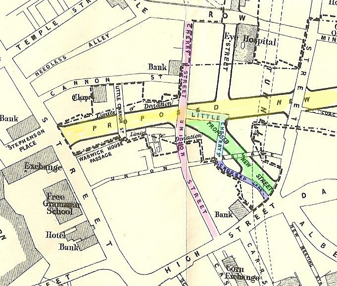
I wouldn't call that a continuation. That is New Meeting Street. On the 1731 map a precursor of Cherry St (unnamed) runs through a cherry orchard and connects to a squiggley unnamed alley which is probably Crooked Lane. New Meeting Street is then already a well defined street. It survived, in part at least, till the latest remoulding in birmingham.
mike
![crookedlane1886[1].jpg](/forum/data/attachments/27/27551-5151b2164401a3143e913684085ac007.jpg?hash=UVGyFkQBox)
![crookedlane1887[1].jpg](/forum/data/attachments/27/27552-6bd878e7c8ce013386b5d45059688dc5.jpg?hash=a9h458jOAT)
M
maxwell bullivant
Guest
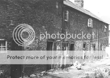
Crooked lane looks a rather foreboding place, not a place to venture in Victorian times late at night methinks. I notice it says "the old lock up" anymore information available on that.? Max
good morning lynn
i reckonised it straight away i have walked down through there many ,many times when i was a small child with my grand mother and my mom when she used to take us shopping in marks and spencers
and we would go back with my grand mother to her coffeee shop in new cannal street
even when i ever ventured to my grand mohers on a sunday i would get the thirty nine bus from the botom of park rd out side ansells and get out indale end and walk down through that crooked lane
many thanks have a nice day ASTONIAN ;; ALAN ;;
phil i wonder if you could repost the 2 pics i posted of crooked lane please..thats if you saved them as i cant seem to find them in my files...thanks phil...
meanwhile ive just come accross this one with a bit of info..
crooked lane came up the side of the brittania pub...tiny one roomed houses that held everything such as tables..chairs..washing tub and mangles..on the other side of the 6ft wide allyway were the toilets..perhaps 3 or 4 to 10 houses..this info comes from someone who remembers the lane and used to walk down it...
The only part of Crooked Lane that I can remember was the part remaining after Martineau St. was put in which would have been latter 1800s and the remaining part was only the back and side of stores...no dwellings at all. The kid's in this picture seem much later than this to me and could even be in the fifties. Other than the Lamb house and some of bombed Martineau St. I have never seen any pictures of Crooked Lane.


I always thought that your first picture Mike, was the part of Crooked Lane that led down to the intersection with Martineau st. I still think it is but looking at the date 1886 this picture might be just before Martineau was cut through and so it could be the lane before being cut off. We have a picture of two people exiting the lane onto Martineau after the second world war (lost) and that is how I remember it with I think the building on the left being just a shell. Anyway, if this is correct then the opening at this time would still have been next to the Lamb House in High Street. I wonder if any of the buildings in the picture was Cadbury's first factory.
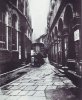
The second picture was after both Corporation St. and Martineau and I can't visualise it's location. It looks about to be demolished.
The upper part of the lane was called Lower Cherry St. before Corporation St. wiped most of it out and then Martineau finished the job but was delayed because of lack of funds. So maybe this delapidated building was in a short time period between projects...and note the wooden fence at the left which may have been around the worksite. Can't place Lyns picture in my mind at this time.
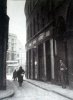
Is this the one Rupert? Two happy shoppers! Viv.

Phil
Gone, but not forgotten.
Lyn
It must be the two Mike has posted because the only ones I have that are not posted here are these two, and neither of them came off this forum. I do however have the ones Mike posted and i got those off here I think.
Phil
It must be the two Mike has posted because the only ones I have that are not posted here are these two, and neither of them came off this forum. I do however have the ones Mike posted and i got those off here I think.
Phil
Attachments
It looks like Crooked Lane grew out of Cherry Street. Around 1750 to the south of Bull Street, the western portion of Cherry Street was straightened and properties were built on its frontage. The north-easterly course of Cherry Street then became Crooked Lane. The section of Cherry Street that's still there today must be, what was, the western end then. Viv.
Oh, I don't know which was first. Anyway what I find is that, whilst the lane was very narrow, the buildings on either side were substantial even before the inclusion of Martineau and Corporation Sts., Some older and low shacks yes, but others stout higher rise. I must admit that I was expecting rambling shacks before Martineau which led me to believe that the photo's were later ones. I suppose that even Crooked lane developed in it's prior years. Anyway one of those buildings in Crooked Lane was Cadbury's first factory and have always wondered where exactly. The premisses on Bull St. were retail oriented mostly. The factory in Crooked Lane moved to Bridge Street later right by the coal wharfes. The photo with the man with a newspaper tucked under his arm is where the ladies in the other pictures are walking down and in the former you can see Martineau at the bottom. One photo before the war and one after...the building to the right of the man is gone after but you can still see the curve at the bottom of the bombed out wall. At least I am assuming it was bomb damage. The building to the right of the ladies is later construction and these would be what I was familiar with in my youth, when negotiating Union passage. Dale end opens out at that point and similar to the Bull Ring was a market (Welsh Market) so I suspect the well would have been usefull for watering livestock. Drovers would have to make do with the many pubs. The Lamb house was very old indeed and suspect it mostly fell down rather than a demo job. An old and historic place this is but the place that I find most enchanting is where there is nothing left at all. Except a curve in the road. That is the bottom of Moat Lane and the curve was around the old moat which must have been pretty much the start.