• Welcome to this forum . We are a worldwide group with a common interest in Birmingham and its history. While here, please follow a few simple rules. We ask that you respect other members, thank those who have helped you and please keep your contributions on-topic with the thread.

    We do hope you enjoy your visit. BHF Admin Team

Coventry Road, Yardley - Melton Villas and Avenue Terrace

maccalenny

proper brummie kid
Hi everyone

I know I had family at these 2 addresses in Yardley in the late 1800s and early 1900s. The street names seem to be long gone as I can't spot them on google maps, although a lot of Coventry Road Yardley looks fairly intact. I'm looking for the Rivers family - I know they were in Avenue Terrace from the 1881 till the 1901 census, and they had moved to Melton Villas by about 1906-7 - this is from an old postcard. My 2 problems are - I can't get Melton Villas to appear on the 1911 census on the site I use, Findmypast, although when I search on the main 1911 census site it shows it. Also, does anyone have an old map that might tell me whereabouts these 2 places were? And anyone know when they disappeared?

Thanks all

Kate
 
Just down from the Swan island, Coventry rd and Church road junction heading towards the Yew Tree was a short road called Melton Gardens. The houses were built in the 60s. I dont know if the were house's there before then. Now these house's along with the road have gone to make way for a new shoping development.
 
cant answer your questions but in the 1911 census there do appear to be 3 rivers families living coventry rd

henry ernest rivers 19 living speedwell house coventry rd.
samuel, mary jane and herbert george rivers luiving 120 coventry rd
william and pattie rivers living 27 lily rd, coventry rd.
 
Robert, On the right hand side down from the Swan Island, off Church Rd was Milton Crescent circa 1929 in my memory , and you could get through to the Coventry Rd. Len.
 
Last edited:
Kate

Judging by the 1920 electoral roll there were 6 Melrose villas, and next to them were 6 burns villas followed by one house and then 5 Warwell villas and then 6 Holmleigh villas. None of these names appear on the 1925 roll and houses around there were not numbered at the time (except as no X of say Melton villas). However looking for the same names in 1920 and 1925 shows that no1 Melton villas was in 1925 No 1611 Coventry road, and no 5 Melrose villas was 1619 Coventry road. Thye were between Warwell lane and Clay lane
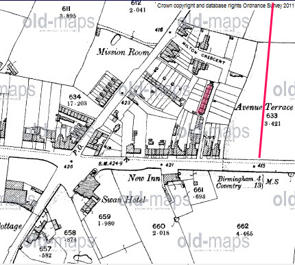
Avenue terrace similarly was between 1552 and 1554 Coventry road. This was on the north side between Church road and Lily road . On the 1903 map below It is shown in red (and named on the map.) It appears to be back to backs. The dotted red line is approx. where lily road would be
Mike

map_c_1905__showing_avenue_terrace2C___lily_rd__off__coventry_road.jpg
 
mikegee, Re your map, between The Swan Hotel & The New Inn pub was Charles Edward Rd, the next 2 roads past The New Inn were Gladstone Rd & Warwell Lane with Emily Rd joining all 3 roads this was circa 1914?.
 
Len
The map was 1903. Onit Cahrles Henry Road, ,gladstone road and Emily road did not exist. Warwell lane is shown but not named. Unfortunately I didn't have a map at a slightly later time such as 1914.
Mike
 
Kate

Judging by the 1920 electoral roll there were 6 Melrose villas, and next to them were 6 burns villas followed by one house and then 5 Warwell villas and then 6 Holmleigh villas. None of these names appear on the 1925 roll and houses around there were not numbered at the time (except as no X of say Melton villas). However looking for the same names in 1920 and 1925 shows that no1 Melton villas was in 1925 No 1611 Coventry road, and no 5 Melrose villas was 1619 Coventry road. Thye were between Warwell lane and Clay lane
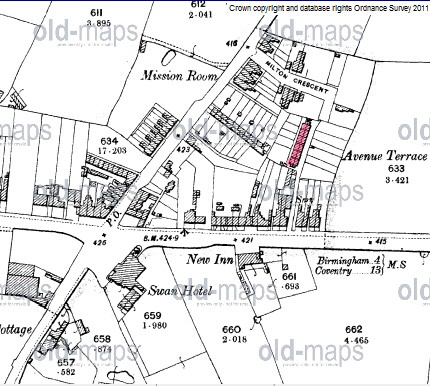
Avenue terrace similarly was between 1552 and 1554 Coventry road. This was on the north side between Church road and Lily road . On the 1903 map below It is shown in red (and named on the map.) It appears to be back to backs. The dotted red line is approx. where lily road would be
Mike

Hi Mike, would it be possible for you to re-post the map showing Avenue Terrace please, if you still have it, My Gt Gt Grandmother Louisa Westwood lived there from at least 1871 to 1891..
Many Thanks
 
Lindy
Can't seem to find the map on my computer. It might have got lost in a crash. however this must be the map (have copied and recoloured). the date is 1c1905, not 1903 (I must have been in error there). You can see the old Swan Hotel at the junction, opposite the site of the Swan shopping centre
Mike


map_c_1905__showing_avenue_terrace2C_coventry_road.jpg
 
Thanks so much Mike :) I know Milton Crescent was still there before The Swan Shopping centre was knocked down to make way for Tesco's, because I took a couple of photos some years back, but Im kicking myself now that I didnt venture further round to where the Terrace would have been to see what remained...I don't know if Milton is still there now, but I would imagine the actual houses of Avenue terrace were swallowed up when the original Shopping Centre was built.
I have found the site where the map is from but wonder if you could let me know how you do the super imposing thing over the top..please
 
Liny
what do yoiu mean by superimposing. If you mean the colouring i just save the map (using Screenhunter , which is a free program where you can save all or part of the screen) and then colour using a photoprogram. i use Photoplus X4, but there is a free version of an earlier version available online.
 
Hi Mike, Sorry, I wasnt sure that was the right word...you did a map photo for me before, I think on the 408 Coventry Road post, or it could have been Villa Road, where you overlaid a transparent map ?? over the top of an older map to show the position of buildings/roads on the old map in relation to the new..I think thats how best I can describe it, but thanks for the colouring info :)
 
Sorry Lindy, i was thinking in relationship to the post here. Google Calls it an overlay, by superimposing is just as good. You need to download Google Earth (if you don't have it).- NOT Google maps. you have to down load the program. then you search for the area you want, and have the map you want to superimpose ready on your computer. You Asjst the magnification on google earth to about the area you want, but with an overlap to the map (so it is easy to see if road positions coincide).
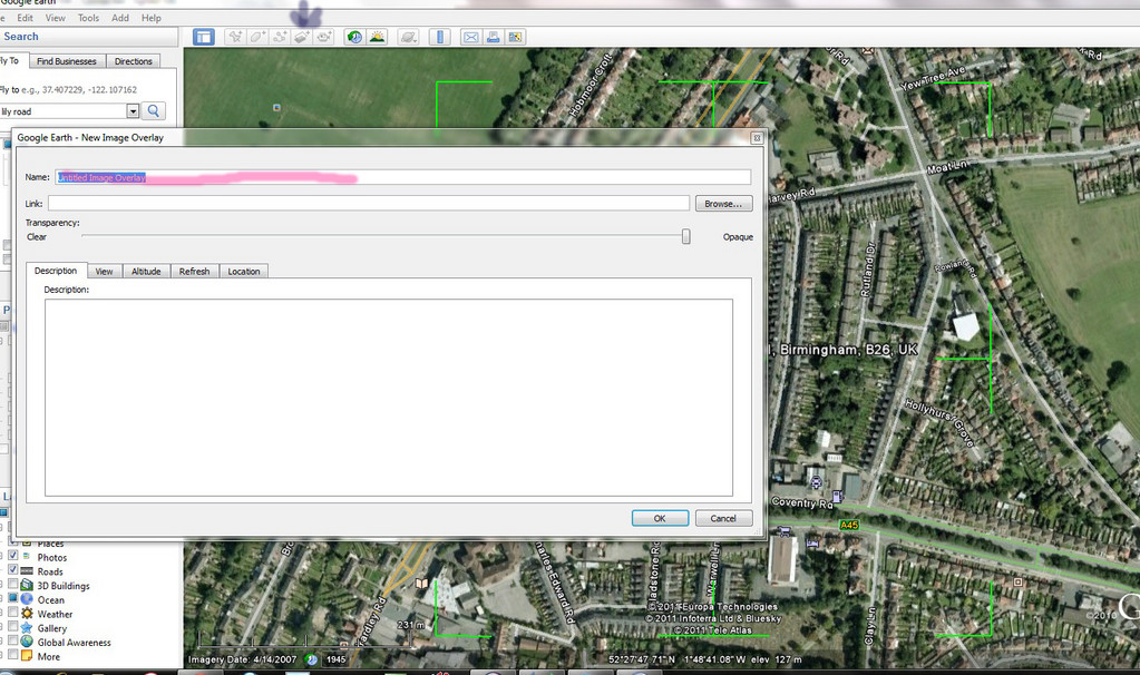
Going to my attachment 1 below.
Click on the button at the top of the screen that I have arrowed in black. You will get the screen with box as shown. Use Browse in that box to get the address (in position shown in red ) of the map you want to superimpose .
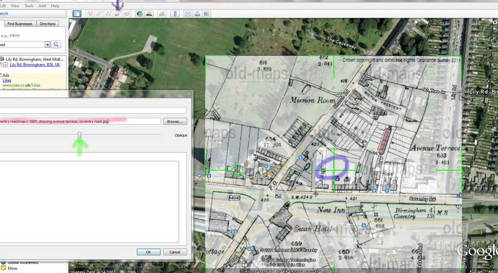
You will then get the map superimposed as in attachment no 2 below.
You can move map around to get it in th eright position by clicking on the gree cross in the centre (which I have circled in Blue).
To help see you are in the right place, the slider in the box goes from (far left) giving no map , through varying degrees of opacity to far right, where you can only see street names through the map You will probably have to cancel the map several times to adjust magnification on google earth to same as on map. this is trial & error !!
You can then save it on google earth , or, as i prefer, copy the view/map using several settings of the slider so you have a record of all details on both the view and the map at the same degree of magnification
Sorry my description doesn't comeup to Leslam's for quality, but hope you get what to do.
Mike
ScreenHunter_1.jpg
ScreenHunter_2.jpg
.
 
Mike thats brilliant !!!..Thanks so much for taking the time to explain in such great detail..I have printed off your instructions and will have a go shortly.. :)
 
Back
Top