-
Welcome to this forum . We are a worldwide group with a common interest in Birmingham and its history. While here, please follow a few simple rules. We ask that you respect other members, thank those who have helped you and please keep your contributions on-topic with the thread.
We do hope you enjoy your visit. BHF Admin Team
You are using an out of date browser. It may not display this or other websites correctly.
You should upgrade or use an alternative browser.
You should upgrade or use an alternative browser.
Church Lane, Aston
- Thread starter MWS
- Start date
Hi mws
Do you know whether its Aston or hands worth as there is a couple of church lane knocking about it could have been Aston church lane
Which is habit further down the red from each other was there a post code with it if it church lane Aston it would have been Aston Birmingham 6 only
Aston church red would have been different number astonian
cookie273uk
master brummie
MWS, I lived in Queens Rd in the 50's and the road layout was somewhat different to what it is now (no Aston Expressway of course), Church Lane continued on from Church Road and continued to Aston Hall Rd (now it only extends to Queens RD). A pre Aston Expressway A to Z or map will show how the road layout differed in the 1950's. Eric
MWS
from Bham
Thank you Astonian and Eric.
Similar to Clifton Road then, where they also lived.
The 1950 address is from the electoral roll and it's in Aston Ward, Bright St is listed prior to Church Lane. I wasn't sure if that was the same as John Bright St.
The 1890s address is from baptism records of St Peters and St Pauls church and just says Church Lane.
cookie273uk
master brummie
MWS, yes Clifton Road also in Aston by Victoria Road, once again the road layout is different (so are the people !!) to the 50's, Had an Aunt lived in Clifton Rd whom I stayed with in the 40's when my Mother was ill. I was born in Queens Rd Aston in 1930 so knew the area well, but it has changed so much, not for the better in my opinion. Eric
MWS
from Bham
My nan and her parents lived at 6 court 9 Clifton Road before she married and her father lived there until the mid 40s. Her grandmother lived at 103 for a time as did her aunt afterwards.
I have come across a fairly good map of the area from about 1885, on it listed what looks like a Church Road, with an adjoining road with just Lane on it which must be it. The bit with Church runs to Queens Road, the bit with Road runs into Thimble Mill Lane, whilst the bit with Lane runs to Lichfield Road.
https://www.londonancestor.com/maps/bc-birm-e.htm
cookie273uk
master brummie
MWS, Mike G is our old Map King and he will certainly have a street map of the area you are interested in around the 50's, that is Church Rd/ Church Lane area, have attached couple of pics where Church Lane crosses Queens Road just before the whole lot was raised to the ground (sad day), this would be in the late 60's. the pub pic shows Queens RD (were the van is)and Church La crossing from left to right, the other pic shows Queens Rd going up to Aston Park with Aston Hall in distance and Church Lane running across. Eric 


Last edited:
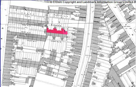
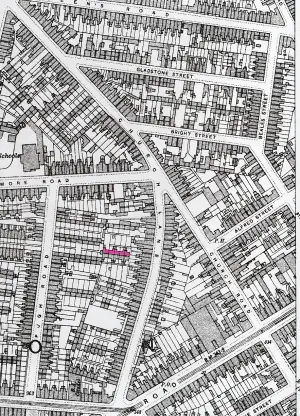
In 1950 the electoral roll lists Doris R Hadley as living at 25 church Lane Aston. Below are two maps, one c 1889 shows court 16 houses in red with what is probably (almost certainly) no 1 marked with a one. and a smaller scale map (c 1913) showing the position in the area , with court 16 houses in red


hi mws
I was just wondering whether or not that she may have been related to the jarratts family whom lived on the lichfield rd aston
they was number cromwell terrace next to thompsons have you followed through on your family tree yet
you did say hadley did you not as i know the jarrats had relies connections within there tree as we was neibours and big friends to the jarratts
and still are we see the one quite regular and the one gergie jarratt used to work for phillips factory astonbrook rd many years ago thee was a picture of the polishers on the forum years ago before they was all shanged hi by our mystry people just thought i wold asked i think the father was named george cannot think of the mothers name just yet slight change around thefather was george and the lad was terry ;and the one still sibbling the youngest is ray they are both in the seventys now parents and brothers have pased away many years ago i have great memories of church lane and alot of the old schol friends from upper thomas street
i would love to turn the clock back tempus fuseus time flys best wishes Astonian;;
sospiri
GONE BUT NOT FORGOTTEN
Mike,
At the time of the 1939 Register, my parents, my brother & I were living at 1 bk 12 Church Lane. The houses behind number 12 presumably had a Court number, although this is not given on the 1939 Register. Could you (a) provide the appropriate map please and (b) tell me the Court number.
Anyone, please, have any photographs of this area of Church Lane prior to the demolition?
Many thanks,
Maurice
Maurice.
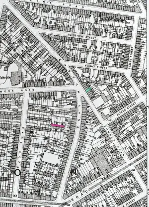
No 12 is not on the c1950 map I usually use to identify numbers, and I presume it was bombed, as seems several other palces in the area. However , I have taken the c1937 map ,marked no 12 in red, and what was presumably 1 back 12 (the house in the court bearest the road) in blue. The court was court 2, and only comprised the one row of 8 houses.

No 12 is not on the c1950 map I usually use to identify numbers, and I presume it was bombed, as seems several other palces in the area. However , I have taken the c1937 map ,marked no 12 in red, and what was presumably 1 back 12 (the house in the court bearest the road) in blue. The court was court 2, and only comprised the one row of 8 houses.

Last edited:
sospiri
GONE BUT NOT FORGOTTEN
Mike,
Many thanks for that. Bombed, Eh? I don't think they stayed there very long and seemed to spend most of their time round at my grandmother's house in Bartons Bank. That had a large cellar and was where we went whenever the air raid sirens sounded. By September 1942 we had moved into a bomb-damaged house in Knowle Road, Sparkhill and Hitler had created our playground by bombing the next five houses - the Birmingham Mail picture is on the Forum somewhere - I must do some date checking and add to my database. Previous to Church Lane, we were at Claremont Road - certainly in April 1937 - but I'm not sure of the number. Again, many thanks for your research.
Maurice
Ray Griffiths
master brummie
Mike,
Many thanks for that. Bombed, Eh? I don't think they stayed there very long and seemed to spend most of their time round at my grandmother's house in Bartons Bank. That had a large cellar and was where we went whenever the air raid sirens sounded. By September 1942 we had moved into a bomb-damaged house in Knowle Road, Sparkhill and Hitler had created our playground by bombing the next five houses - the Birmingham Mail picture is on the Forum somewhere - I must do some date checking and add to my database. Previous to Church Lane, we were at Claremont Road - certainly in April 1937 - but I'm not sure of the number. Again, many thanks for your research.
Maurice
Ray Griffiths
master brummie
Mike,
At the time of the 1939 Register, my parents, my brother & I were living at 1 bk 12 Church Lane. The houses behind number 12 presumably had a Court number, although this is not given on the 1939 Register. Could you (a) provide the appropriate map please and (b) tell me the Court number.
Anyone, please, have any photographs of this area of Church Lane prior to the demolition?
Many thanks,
Maurice
Ray
If you go to https://birminghamhistory.co.uk/forum/index.php?threads/birmingham-1969-73.23229/ , the first photo in post 10, and several in post 11 show buildings while demolition was proceeding
If you go to https://birminghamhistory.co.uk/forum/index.php?threads/birmingham-1969-73.23229/ , the first photo in post 10, and several in post 11 show buildings while demolition was proceeding


