-
Welcome to this forum . We are a worldwide group with a common interest in Birmingham and its history. While here, please follow a few simple rules. We ask that you respect other members, thank those who have helped you and please keep your contributions on-topic with the thread.
We do hope you enjoy your visit. BHF Admin Team
You are using an out of date browser. It may not display this or other websites correctly.
You should upgrade or use an alternative browser.
You should upgrade or use an alternative browser.
canal st pics wanted
- Thread starter Astoness
- Start date
guilbert53
master brummie
Where is Canal st, I cant find it in Google Maps.
There is a New Canal St.
There is a New Canal St.
It was just off Lancaster St not too far from the Bull Public House where the next meet is being held, the Gun Quarter.was it in Aston? (Just so I know for certain what I am looking for)
Hutton's History of Birmingham lists a Canal Street somewhere between Coventry and Coleshill Street. There were 13 houses there at the time. Viv.

Hi Lyn. Might be. But I suppose Canal Street could have become New Canal St, and it's also between Coventry and Coleshill Streets. So maybe it was made into a longer street at some time. Hopefully someone will be able to tell us. Viv.
See what you mean Lyn. Had a look around Streetview. The first view from Staniforth Street is where I'd estimate Canal Street once stood. Looks like it's now a car park. The second view is looking from Lancaster Street/Newtown Row ( bit dark). I think Canal Street would have been behind those hoardings. Viv.


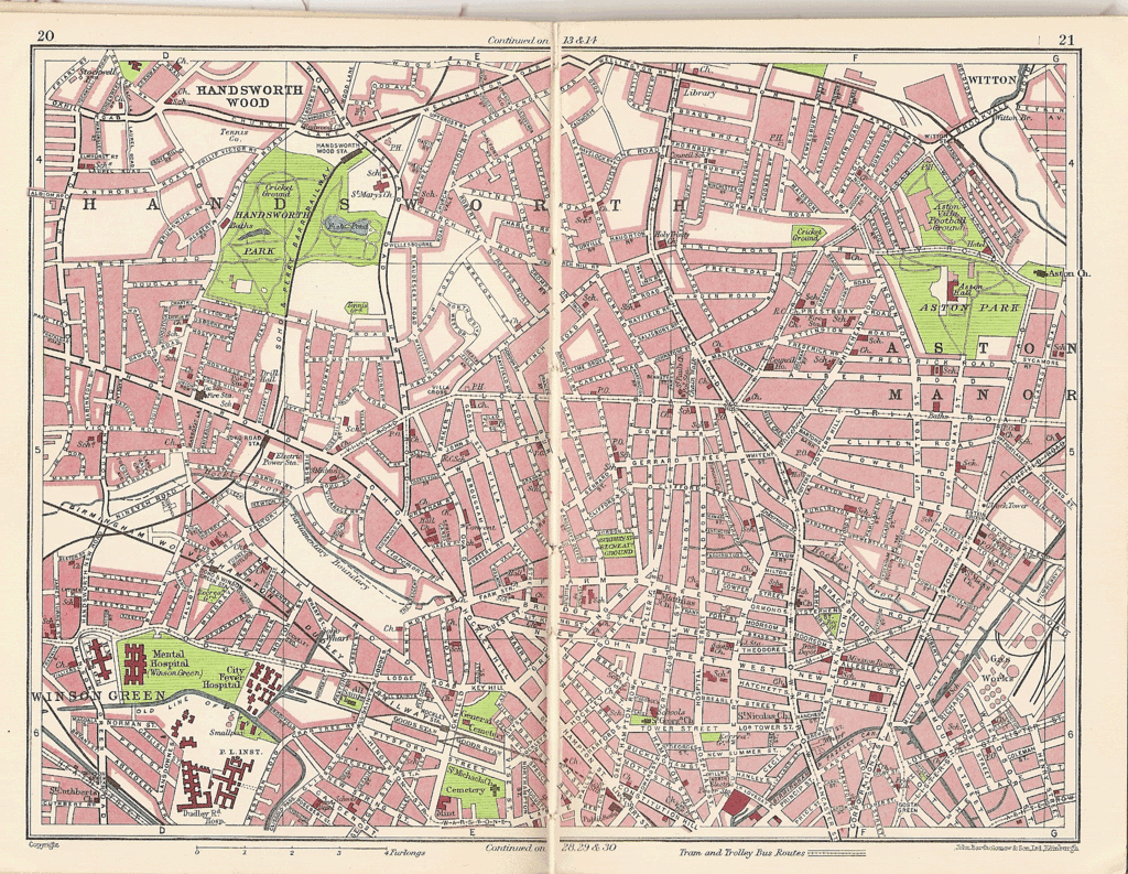
This is a great map, Lyn, helped me find my way round Soho Road, Soho Hill and into Hockley, it has changed so much, I have had to close my eyes to try recalling what it did look like. When I was a child in Handsworth we had a little dog who was rescued from Hockley Culvert along with his Mum and Sister. He lived to a ripe old age of 17. Thanks for all these wonderful pictures and the memories that go with them. Back to the map, I shall have fun picking out all the places I remember.
Katie
Katie
hi katie that map has got me out of trouble more than once lol... and what a lovely story of your little rescued dog..you probably know this already but just in case...if you save that map to your files you will then be alble to enlarge it...
hi viv...yes i would agree with you thats roughly where canal st would have been...
if memory serves me right the car park ground used to be the fire service training ground...
lyn
hi viv...yes i would agree with you thats roughly where canal st would have been...
if memory serves me right the car park ground used to be the fire service training ground...
lyn
Looks like it's been empty for quite a while. Just enough room for 13 houses! The New Canal Street over towards Curzon Street would be entirely different. There seems to be very few references to Canal Street either. I've also noticed when searching that New Canal Street sometimes seems to be called Canal Street. Viv.
lynne webb
GONE BUT NOT FORGOTTEN
Viv according to the Census, there were at least 20 houses and 3 Courts. I would imagine it was about the same length as Lawson St., the one with the Turks Head on the corner.
Lynne.
Lynne.
Hi Lynne and Lyn. Maybe then they were similar to Bagot Street houses. I expect most of these would have disappeared with the slum clearances. Viv.