-
Welcome to this forum . We are a worldwide group with a common interest in Birmingham and its history. While here, please follow a few simple rules. We ask that you respect other members, thank those who have helped you and please keep your contributions on-topic with the thread.
We do hope you enjoy your visit. BHF Admin Team
You are using an out of date browser. It may not display this or other websites correctly.
You should upgrade or use an alternative browser.
You should upgrade or use an alternative browser.
bridge st west
- Thread starter Astoness
- Start date
")


mike
Thanks for info and correction,it would have been Richmond Terrace and not Place.There were two rows of houses running at right angles off BSW.and I lived in No.10 the last but one on the right hand side.There was also two houses at the top facing down towards BSW.Even allowing for the noise and vibration that came from the factory that backed onto the house I quite enjoyed my stay there.Didn't think much of the Atkinsons beer that was sold in the Wellington though.The houses in Richmond Terrace had small front gardens which was unusual for that area.
Thanks again
Pembroke
Hi mike
Sorry to bother you again.It was in my mind as Richmond Place but thought my memory was playing up a bit when you said you could on only find Richmond Terrace.Have,however come across photos taken of the "nippers"in 1961 and photos are noted as being taken outside 10,Richmond Place.The situation you give for Richmond Terrace is identical to the one I remember for Richmond Place.Could name have been changed officially for some reason or perhaps unofficially over the years by the "locals".
Regards
Pembroke
It is listed as Richmond terrace until at least the 30s on maps, and in directories as that till at least 1962, but could well have been locally known as "place". I can't see any other long terrace(s) with at least 10 houses in them around that position other than that, so I'm pretty sure that is the one you are looking for.
Alan Tucker
master brummie
Mike
Can you also help me? I am doing research into William Mills of Mills bomb/grenade fame. His 'Munitions' factory was at 192, Bridge Street West and was opened in addition to his Smethwick and Sunderland works during the First World War. It was next to a police station. Can you post a map with more of Bridge Street West including a date.
Thanks

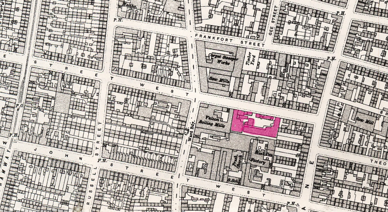
The Mills works appears to be next to the Vulcan rolling Mills, and so must be the buidling in red (though possibly not including all the buildings facing the road). Don't know which was the police station (which is nos 204,206). the outline of the works is the same in 1889, so have included larger scale map from that period also.
Mike
Alan
The Mills works appears to be next to the Vulcan rolling Mills, and so must be the buidling in red (though possibly not including all the buildings facing the road). Don't know which was the police station (which is nos 204,206). the outline of the works is the same in 1889, so have included larger scale map from that period also.
Mike
hi mike bridge st police station is right on the corner of bsw and summer lane...built early 30s i believe and its still there...
lyn
Alan Tucker
master brummie
Thanks Mike and Lyn
