superdad3
master brummie
Boundaries; random thoughts
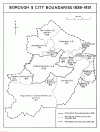
The changes to city boundaries has been touched on in many posts over the years. I got interested in this topic when researching the Wake Green estate which is the area around St Agnes Church, Moseley. The map below sums up the growth of Birmingham [apols. if it has been posted before].

It confirms how large Kings Norton & Northfield UD was. I always thought Aston MB was as large as Birmingham – perhaps it was just by population & development at the time? Sparkhill and Wake Green were in Yardley but Sparkhill was very much the big brother by then with Yardley Council House on Stratford Road [now houses Sparkhill Library]. Also Yardley Wood!
Smethwick was historically part of Harborne and both were originally in Staffs. Hence the naming of the parish of North Harborne [Holy Trinity] when created in 1842. And then we have Ridgeacre/Quinton – originally in Shropshire [detached] and then in Worcestershire.
The topic is endless.
But of course these boundaries were primarily for civil administration before the local authority was responsible for so much more. Parish boundaries were much more important back in the day and still are for family history. Workhouse boundaries were different again and were later used as the basis for Registration District boundaries causing many a trip for the unwary. Just because a birth is registered in Kings Norton, it doesn’t mean that they were born there. It was the registration district – they might have been born in Moseley, Harborne or even Wythall.
What a complex subject boundaries are.
The changes to city boundaries has been touched on in many posts over the years. I got interested in this topic when researching the Wake Green estate which is the area around St Agnes Church, Moseley. The map below sums up the growth of Birmingham [apols. if it has been posted before].

It confirms how large Kings Norton & Northfield UD was. I always thought Aston MB was as large as Birmingham – perhaps it was just by population & development at the time? Sparkhill and Wake Green were in Yardley but Sparkhill was very much the big brother by then with Yardley Council House on Stratford Road [now houses Sparkhill Library]. Also Yardley Wood!
Smethwick was historically part of Harborne and both were originally in Staffs. Hence the naming of the parish of North Harborne [Holy Trinity] when created in 1842. And then we have Ridgeacre/Quinton – originally in Shropshire [detached] and then in Worcestershire.
The topic is endless.
But of course these boundaries were primarily for civil administration before the local authority was responsible for so much more. Parish boundaries were much more important back in the day and still are for family history. Workhouse boundaries were different again and were later used as the basis for Registration District boundaries causing many a trip for the unwary. Just because a birth is registered in Kings Norton, it doesn’t mean that they were born there. It was the registration district – they might have been born in Moseley, Harborne or even Wythall.
What a complex subject boundaries are.


