• Welcome to this forum . We are a worldwide group with a common interest in Birmingham and its history. While here, please follow a few simple rules. We ask that you respect other members, thank those who have helped you and please keep your contributions on-topic with the thread.

    We do hope you enjoy your visit. BHF Admin Team

Birmingham Canal Disaster

  • Thread starter Thread starter O.C.
  • Start date Start date
O

O.C.

Guest
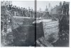
The disaster that took place at Edgbaston a suburb of Birmingham early in the morning of Sunday 1872.
While constructing a new short railway line which ran to Harborne alongside the Birmingham and Worcester canal it required altering the bed of the canal and taking off a portion at its width on the West side which was given to the railway, but compensating for this deduction by adding an equal space on the East side.
This part of the canal was drained of its water after erecting a dam above at Somerset Road Bridge
A thousand labourers were employed in digging out the earth and bricklayers were all set to start building the new embankment walls. The work was due to finish on the Saturday and water was allowed to flow into the new bed of the canal through a 12inch valve fitted in the lock.
The upper part of the canal in the direction of Worcester was full of water and by some careless mistake or blunder (or malicious) at 7 o clock on the Sunday morning the lock at Edgbaston was suddenly opened and the water poured down in a tremendous torrent towards the lower levels of Birmingham first filling the canal then rising rapidly up the embankment, which burst under the tremendous pressure causing a great flood.
Newspaper picture shows repairing the breach in the embankment and map shows where it happened
 
No Sylvia as it happened at 7o'clock Sunday morning and no one was at work
Be nice to see a Google Earth photo of the part I have mentioned if someone can put one on
 
Oh dear, Cromwell, I feel another argument breaking out.
The Harborne branch railway ran from a junction with the Stour Valley line (New Street - Wolverhampton HL) quite close to Dudley Road, and you can still see the bridge piers and the bricked-up tunnel opening, into which the line disappeared to cross under Northbrook Street before skirting the south side of Summerfield Park and curving round with stations at Rotton Park Road (island platform with 2 tracks) and Hagley Road (single platform, no sidings). 2 1/2 miles later bit reached the terminus at Harborne. The Harborne Railway Company was authorised by Act of Parliament in 1866, but did not start building for five years or so, and the line opened on 10 August 1874. It owned no trains, but the London & North Western Railway worked the trains, until the railways were grouped into four large companies in 1922, and the line was the best earner of all the suburban lines in the Birmingham district.
Coming now to the canal accident at the place shown on the map, that was on the Worcester & Birmingham Canal, and the parallel railway was authorised in 1871 and opened as a simple single track line from the Midland main line to Bristol at Lifford as far as a temporary station at Granville Street, before being doubled and extended into New Street at massive expense in 1881 - 1885.
A account of building this extension is given in "The Life and Work of Joseph Firbank, JP, DL, Railway Contractor" describes the complications of extending the line into town, which involved digging under the canal in some detail, but this was ten years after the accident Cromwell quotes.
What I don't understand why the canal should have been diverted on to a curve at this point, while the railway runs in a fairly straight line, as shown on the aerial photos. Cromwell's map shows the railway hugging the winding course of the canal at this point. A bit of a mystery.
Peter
 
Peter I have not got a clue about if its correct or not but it was all copied out of the newspaper of 1872 so cannot answer anymore
Map is 1883
 
I have been looking at this for a while and there do seem to be some anomalies. Firstly, the canal seems to run in a smooth curve around the bend there i.e. there is no abject change of curvature from either direction except for the short section of the break which appears to be about 105 feet long and this seems to be the only section of the canal that was bunted over. Maybe the railroad never did  follow the run of the canal exactly. Possibly due to a screw up in surveying, the curve of the track intersected the towpath just in that one section and since much of the track had been laid they chose to move that short piece of canal over. They dammed the canal at Somerset road because the canal would be narrow there where it went under the bridge and it would be easy to drop off material. Possibly made a temporary wooden lock. (Might be some remains to be seen) Anyway the keys did not hold apparently. Bet some poor draughtsman got shit. I wonder if they had to dam the canal in the other direction or was there an existing lock. Can't tell from GE. The map mentions a railroad but does not indicate it except to suggest that it followed the canal. I don't think that is gospel. Anyway the account mentions a 12" valve in the lock. Does not mention if this was at Somerset Road. Probably was. Anyway it seems to me that this temporary structure attached to existing brickwork just did not hold long enough. The towpath on the canal is very close to the rail track. Wonder what difficulties the boatmen had with their horses.
There are some things that we can see here though. 1000 men are said to have been hired for this short stretch. Probably had to be done in a hurry. Never the less, there are still something like 2000 miles of canal even now being used in England. I don't know about you but the Egyptian Pyramids may be one of  the swank wonders but compared to this its Leggo. Gees these canals even worked. Bear in mind that this is just an hypothesis. I am not like George Patton I was not there at the time. (Saw the movie last night)

Regards
 
Rupert, When the bank burst there was no railway so something made them alter the course of the canal 
the Elan Aquaduct runs along side the top of that bulge (to the West side of it ) but that was not finished till after the 1914-18 war
 
Rupert,Peter this a 1940's map which shows the Elan Aquaduct heading straight for the top of the Bulge
So if the Railway was not built why was the canal shifted over? total puzzle
 
Cromwell seeing that map reminds me when the pipe burst in Vincent Drive just by the National Blood Transfussion building on the QE site,I think it was a 36" pipe and the damage it caused was un-believable,it flooded building and service ducts around that area,and interupted services for weeks.Not sure of the date but around 1990.I've being looking for some photos I took at the time ,but they seem to be missing.

Colin
 
This is another case of a canal bank bursting, this time it was in Great Charles Street in 1906
 
That picture is more normal I would have thought, the first picture is not to scale, if you take the size of the men working, the depth of the canal must be 40 -50 Feet deep.
 
Nick if you are referring to the first pic you have read it wrong the canal overflowed up the Embankment and the embankment burst
 
Just read about another canal breach in 1899 at Dudley Port, water from two miles of canal gushed into a 300 foot marlhole that supplied a brick works, damage to the canal cost £50,000 and £3,500 to the brick works.
 
There are n images on this thread so posting this one of the Edgbaston canal breach of 1872. Viv.

image.jpeg
 
The canal burst took place in May 1872 and involved the Worcester and Birmingham Canal, not the BCN. The fine engraving was published in the Illustrated London News (June 8th, 1872) as well as somewhat distorted account of events. Better reports are available in the Birmingham papers, mentioning that most of the contractors men had departed when the breach occurred. It was on a section of the canal near Five Ways, where through the building of the West Suburban Railway the original wide canal had been narrowed and the railway had been built on the site of the original towpath and west side canal bank. Such work involved alteration and reconstruction of the Worcester and Birmingham Canal, which was drained for a length. Once the water was let in again the weight of water found a weak point leading to the burst of the canal and the flowing of water in to neighbouring streets, houses and gardens. The construction of a man hole by the navvies was suggested as a possible cause.

Any confusion with the BCN must be discounted as where the Harborne Railway crosses over the canal is in a cutting, and again bounded by the Stour Valley Railway. It is difficult, nay impossible, for canals to burst in cuttings! They can flood however.
 
To explain the location, I attach copy of 25in ordnance survey that shows the section and embankment near the approach to the tunnel, and where the boat house is marked. The flood waters reached properties in Pakenham Road (on the right). John Aird was the contractor for the original WSR to Kings Norton.Edbg1.png
 
Last edited:
Hi viv
on the thread number 12 it stated by our dear old friend and myfriend indeedwas of course QC
And you correctly know he is no longer amember of the forum, sadly
But anyway he stated the cannal banks had burst , but in fact it was the lock along side grt charles street in 1906 as corrected
It was a source of considerable attention for birmingham residents
I have down loaded a picture of the approiate time it happend and its year
this will be one of the first series of cannal water ways i have got several more pics to follow
have a good day viv , and fellow members for today
1, Picture ,
 

Attachments

  • Untitled.jpg
    Untitled.jpg
    1.1 MB · Views: 35
Nice image of the Canal Burst for 1901 which happened at the end of the Newhall Branch, near Lionel Street, after workmen had made alterations to premises. I have pictures on page 55 of my Birmingham's Canal Book reproduced from the Birmingham Reference Library Collection, then housed on the 6th floor of what probably the best reference library in the country. There are also various line drawings published in the local press at the time of the burst.

Regarding the Worcester & Birmingham Canal burst. The Birmingham Daily Post May 27th 1872 refers to John Aird's concractors building a 2000 yard long water wall from Granville Street Bridge (where a stop gate was placed) to a second stop gate at Somerset Road. The originals WSR was a single track railway made from Granville Street Station to join the Midland Railway at Lifford and the route followed the canal closely for its length. The Firbank work comprised the subsequent reconstruction and widening of this railway to two tracks that formed part of the Midland Railway expansion in this area including the construction of a second half to New Street Station.
 
Back
Top