-
Welcome to this forum . We are a worldwide group with a common interest in Birmingham and its history. While here, please follow a few simple rules. We ask that you respect other members, thank those who have helped you and please keep your contributions on-topic with the thread.
We do hope you enjoy your visit. BHF Admin Team
You are using an out of date browser. It may not display this or other websites correctly.
You should upgrade or use an alternative browser.
You should upgrade or use an alternative browser.
Beggars Bush Inn
- Thread starter Phil
- Start date
A
Ann B
Guest
Haven't a clue Phil. Selly Oak?
Ann
Ann
A
Ann B
Guest
Jean,
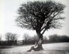
He's thinking 'How strange, in a 100 years time people will be trying to guess where I am.'
Ann
He's thinking 'How strange, in a 100 years time people will be trying to guess where I am.'
Ann
Lloyd
master brummie
Simple, really.Where is This?
Oakengates, (Oak 'n gate) Shropshire.
He's thinking of the girl he loves, Teresa Green.would love to know what the man's thinking????
Phil
Gone, but not forgotten.
col h
Well done, its The Beggars Bush in a much changed surroundings. As these photos begin to show, but even they do not indicate just how busy it is today. I dont think our friend would be sitting in that same spot today for long.
There is a local legend that tells of a beggar buried at the junction of the Chester Road and Jockey Road there was a hawthorn bush on the Chester Road here before the 1930s which local people called the Beggar's Bush and was always believed to be the bush under which the beggar had died. As the bush also marked the parish boundary between Aldridge, Perry and Sutton Coldfied, no-one could agree who should pay for the burial and so he was buried where he lay.
Phil
Attachments
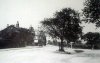
There was a place named Beggars Bush in the early 1800s. Many will know it because of the inn of this name. A discussion arose on this forum from the postcard below titled "The Beggars Bush, Erdington". The following posts records that discussion.
Think this one's debatable. It's labelled the Beggars Bush 'Erdington' . Was it Erdington at this time? (The ladies in the image look Edwardian). Viv.

Think this one's debatable. It's labelled the Beggars Bush 'Erdington' . Was it Erdington at this time? (The ladies in the image look Edwardian). Viv.

Radiorails
master brummie
https://birminghamhistory.co.uk/forum/index.php?threads/old-street-pics.38737/page-199
Post 3979, by Dennis Williams, gives a lot of information about this place.
Post 3979, by Dennis Williams, gives a lot of information about this place.
Pedrocut
Master Barmmie
There is also info on William Dargue’s site here...
https://billdargue.jimdo.com/placenames-gazetteer-a-to-y/places-b/beggars-bush/
But in the post 3797 it says that Erdington was once part of Staffordshire…I’m not sure that it was ever in Staffs, always with Aston and in Warks???
https://billdargue.jimdo.com/placenames-gazetteer-a-to-y/places-b/beggars-bush/
But in the post 3797 it says that Erdington was once part of Staffordshire…I’m not sure that it was ever in Staffs, always with Aston and in Warks???
Thanks all. So it was simply on the Erdington border. That's a very comprehensive account Alan in your link #670. Thanks. Viv.
Pedrocut
Master Barmmie

The Post in "Old street pics" mentioned above leaves a few unanswered questions and as more information becomes freely available maybe some light can be shed.
The Birmingham Gazette prints the proposed Inclosure of Lands within the Royal Town, Manor, and Lordship of Sutton Coldfield, in the county of Warwick in January 1827.
On Coldfield Common...the "Setting up of carriage roads and highways"....one of the roads...
Number 4...A Road of 40 ft commencing at a certain bush called Beggars' Bush, near the said turnpike Road, and extending in an eastward direction over the said common, and terminating at the Horse and Jockey Public House. (Jockey Road?)
No 2...a road of 40ft commencing at the east end of the road in the hamlet of Erdington, called Gravelly-lane Road, and extending in an eastwardly direction over part of the said common into the said turnpike road.
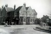
The thumbnail OS Map, for around 1882, shows the boundary between Staffs and Warks more or less along the Chester Road and the Beggars' Bush tree is on the boundary. The hamlet of Erdington is quite a distance away and I can't find any evidence that it was once in Staffs, and is hardly ever mentioned in connection with the Bush.
The map also gives the name of the pub as the Bush, but in all references I can find from 1858 through to 1939 it is referred to as The Beggars Bush with or without the apostrophe in both places! The Inclosure shows the apostrophe after the "s."
The advert for the sale of the Beggars' Bush in 1884 states the inclusion of stabling and a Coach-house.
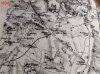
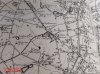
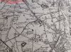
Three map references between 1834 - 1909 show
1834 - labelled as "Beggars Bush" - no 'Inn' or 'Tavern'. So presume it was a place not an inn at that time. The early 'Beggars Bush' tavern/inn was supposed to be nearby but can't see anything marked on the 1834 map.
1895 - labelled simply but clearly as "Inn". No mention of Beggars Bush (as a place) Why?
1909 - the 1895 map was updated in 1906 and published in 1909. Again it simply but clearly labelled an "Inn". No mention of Beggars Bush as a place either. Why?
Maps posted below.
Viv.
Attachments
Pedrocut
Master Barmmie
Three map references between 1834 - 1909 show
1834 - labelled as "Beggars Bush" - no 'Inn' or 'Tavern'. So presume it was a place not an inn at that time. The early 'Beggars Bush' tavern/inn was supposed to be nearby but can't see anything marked on the 1834 map.
1895 - labelled simply but clearly as "Inn". No mention of Beggars Bush (as a place) Why?
1909 - the 1895 map was updated in 1906 and published in 1909. Again it simply but clearly labelled an "Inn". No mention of Beggars Bush as a place either. Why?
Maps posted below.
Viv.
On the first map marked 1834, and just below the Beggars' Bush, there is a Jordan's Grave mentioned. No.5 road on the Inclosure reads...
Width 30ft commencing near a certain place called Jordan's Grave, at the road that separates the hamlet of Erdington from the manor of Perry Barr, and extending in a north easterly direction to the said turnpike road, continuing in the same direction from the said turnpike road, and terminating in the last described road. (No.4 Jockey Road?)
By 1881 Jordan's Grave has disappeared under the St Mary RC College.
The Inn was not built until 1841, and so the Beggars' Bush on the 1834 would describe a place, and there is the first mention of Erdington!
Radiorails
master brummie
Yes it seems apparent that 'Beggars Bush' started out as a place name. It was on a crossroads, it seems, which were well used thoroughfares - as they are now. An ideal place to beg I suggest. 
So many ancient place names, particularly at high points or cross roads, have names connected with their useage rather than location. In rural areas long forgotten place names used by local authorities are often remembered and used by those living there. I found this out many years ago when attending fires in the rural areas of Devon. Binoculars were unofficial kit, but highly useful and were carried by some officers as modern OS maps often did not use ancient or strictly local place names.
So many ancient place names, particularly at high points or cross roads, have names connected with their useage rather than location. In rural areas long forgotten place names used by local authorities are often remembered and used by those living there. I found this out many years ago when attending fires in the rural areas of Devon. Binoculars were unofficial kit, but highly useful and were carried by some officers as modern OS maps often did not use ancient or strictly local place names.
Lady Penelope
master brummie
I seem to remember a bit of folklore about the beggar's bush but perhaps someone can confirm it? When a vagrant died the parish of death was responsible for the burial. In this case neither Sutton Coldfield or Erdington wanted the expense so he was buried under the bush. Now, that doesn't help with the boundary does it as we still don't know where it was? I have a map or that areas from pre-enclosure days so I will look for it when I get home.
When I was growing up in Court Lane the address was always 'Erdington, Warwickshire'.
The address for the Princess Alice Orphanage which was on the opposite corner to the Bush was 'New Oscott, Sutton Coldfield'.
When I was growing up in Court Lane the address was always 'Erdington, Warwickshire'.
The address for the Princess Alice Orphanage which was on the opposite corner to the Bush was 'New Oscott, Sutton Coldfield'.
The 1848 tithe map of Aston, which includes Erdington, states that all of Aston juxta Birmingham was in Warwickshire. Ave been trying to work out th position of where the Beggars Bush would alter be from the tithe maps on the genealogist website , which are not easy to access by exact position as they are set up to search by names of people, the roads are very different from later, an tht emapping does not seem very accurate, but it seems to me that the position of the Beggars Bush was outside Erdington at that time.
The larger scale c 1884 map shows the Inn named as the Bush Inn, so maybe the story of the beggar gave rise to the change of name.


The larger scale c 1884 map shows the Inn named as the Bush Inn, so maybe the story of the beggar gave rise to the change of name.
Bob Davis
Bob Davis
I lived in Court Lane, I was born at 369 which was on the left hand side coming down from Chester Road, but in 1939 we moved over into the houses just built to No 396. 369 was in Sutton Coldfield, 396 was in Birmingham. The policeman from Sutton Coldfield would walk down Court lane from Chester Road on the Oscott College side and opposite the Barracks (the row of cottages where the Chipman family lived and kept their donkeys), he would cross over and walk down as far as the shop and the bus stop and then walk back up. This was because of the boundary and the Greyhound pub (the next building after the shop) was in Birmingham but Maddocks shop was in Sutton Coldfield. My father always said that the boundary ran up against the front of the houses on the right hand side, not the middle of the road as the policeman always said. I do know our rubbish was collected in the electric dust carts of Birmingham and over the road in the odd looking Shelveoak Drury lorries of the Royal Borough. At Sutton library they had a list of the house numbers in the roads where the boundary was questionable and because I went to BVGS they allowed me to join and taske out books, but pointed out that I did live in Erdington. At this time there was always discussion as to where the boundary was apropos Oscott College and College Road and on the road to Kingstanding and often it was only the street name signs that gave any clue. I do know that Princess Alice's Orphanage was in Sutton ColdfieldI seem to remember a bit of folklore about the beggar's bush but perhaps someone can confirm it? When a vagrant died the parish of death was responsible for the burial. In this case neither Sutton Coldfield or Erdington wanted the expense so he was buried under the bush. Now, that doesn't help with the boundary does it as we still don't know where it was? I have a map or that areas from pre-enclosure days so I will look for it when I get home.
When I was growing up in Court Lane the address was always 'Erdington, Warwickshire'.
The address for the Princess Alice Orphanage which was on the opposite corner to the Bush was 'New Oscott, Sutton Coldfield'.
Bob

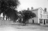
Beggars Bush around 1900-1920. Image from Birmingham Libraries which gives the location as New Oscott. Viv.

Lady Penelope
master brummie
New Oscott was only called this after the college moved from a couple of miles away at Old Oscott in 1838. When did it become a 'district' rather than just the college address?
I don't know the answer Lady P but we do know New Oscott was appearing on maps in 1880. And Pedro's advert in post #2 suggests the area was 'filling up' in 1884. But I suspect that, as the name was used for the area when the College was built there, it would have become a district not too long after the building was completed. But afraid no evidence. Viv.
Radiorails
master brummie
Lady P is correct in saying that New Oscott college started in 1838 having moved from Old Oscott, which became known as Maryvale. There is a lot of history about these two places but the thread is about a pub, Beggars Bush, so I will not post any links.
I would imagine the place name, New Oscott, was soon adopted - even if unofficially in the beginning - to avoid confusion between the two colleges.
I would imagine the place name, New Oscott, was soon adopted - even if unofficially in the beginning - to avoid confusion between the two colleges.