• Welcome to this forum . We are a worldwide group with a common interest in Birmingham and its history. While here, please follow a few simple rules. We ask that you respect other members, thank those who have helped you and please keep your contributions on-topic with the thread.

    We do hope you enjoy your visit. BHF Admin Team

Banbury Street, Digbeth

simasterb

proper brummie kid
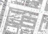
I am trying to locate some old pictures of banbury street, digbeth, and in particular number 2 banbury street which according to the current google street map - number 2 is next door to the birmingham gun barrel proof house. The current google street view, shows some factory buildings with corrugated iron roof where number 2 would of been. I presume the original houses were knocked down. Has anyone got any old pictures/photos or any info relating to houses on banbury street ?
 
What period are you referring to. I ask because , certainly up to the 1920s , no 2 was at the opposite end of the street on the south side. G
The numbering that appears on google is very vague and they do not claim it to be accurate. It may have changes since WW2 of course, but certainly till the 1920s it was at that end
 
Last edited:
ok thanks for the info, the period is from 1881 census. So its on the opposite side of the road ? maybe opposite the eagle and tun public house then ? would still like to see some pictures of the street if anyone can also help too.
 
Sorry .slightly mislead you. It should have read "on the opposite END of Banbury St, on the south side". Below is a map showing that end with some numbering . You can see that exactly which is no 2 is not clear from the information I have .
 

Attachments

  • map c 1889 showing west end Banbury St with some numbering.jpg
    map c 1889 showing west end Banbury St with some numbering.jpg
    298.1 KB · Views: 16
Back
Top