• Welcome to this forum . We are a worldwide group with a common interest in Birmingham and its history. While here, please follow a few simple rules. We ask that you respect other members, thank those who have helped you and please keep your contributions on-topic with the thread.

    We do hope you enjoy your visit. BHF Admin Team

Alcester street

RuthinBrum

Brummie babby
Hello, in 1921 my dad was living at 90 Alcester Street, now redeveloped of course. He was attending King Edward's School Camp Hill near by. Can anyone point me towards an old photo of the area, or any history? Thanks, Ruth
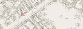
 
The numbered OS map from 1950 does not include no 90, as it had by then been demolishaed. However the map from c1889 below shows no 90 in red. I can be certain of that as the kellys directory shows 88 and 89 as a coopers, and 91 as a builders.yard . It was almost opposite Highgate park, part of which can be seen on the map., and a just down the road from ?rowton house, which in 1921 was a sort of hostel for those down on their luck, though was much later converted to a luxury hotel (though I think that has now closed, though the building still stands

map c 1889 showing 90 Alcester St.jpg
 
I have moved this to then streets and neighbourhoods section and re-titled it so that it will be clearer to others what you are asking for
 
The numbered OS map from 1950 does not include no 90, as it had by then been demolishaed. However the map from c1889 below shows no 90 in red. I can be certain of that as the kellys directory shows 88 and 89 as a coopers, and 91 as a builders.yard . It was almost opposite Highgate park, part of which can be seen on the map., and a just down the road from ?rowton house, which in 1921 was a sort of hostel for those down on their luck, though was much later converted to a luxury hotel (though I think that has now closed, though the building still stands

View attachment 166528
Brilliant, thank you SO much! I hadn't realised it was so close to Highgate Park which was a gracious place back then - it even has the Drinking Fountain:-) This is such a detailed map. I've just realised I have the Godfrey old OS 1888 Birmingham (South) edition and never thought to look in it, but it's not as detailed as yours. Have you scanned the one here? Finally, how did you colour number 90 red? It looks huge so I expect my family of 2 parents and 2 boys would've been sharing it, I wonder how many other families would've been there? It is so helpful. Thanks again, Ruth.
 
You are a treasure and a delight! I went in to the old library years ago and bought copies of some of the old maps which must've been from Town plans. I presume they are available in the new library - a treat to come one day... Thanks again, Ruth.
 
An aerial view dated 1937 shows buildings on the site of number 90 on Alcester Street along from Highgate Park entrance. Rowton House in the top right corner of the view.
2_Alcester St 1937.jpg

An aerial view dated 1937 shows the back of the buildings on the site of number 90.
Highgate Park 1937.jpg
images source 'britainfromabove'
 
Thank you as well as mikejee:) These are very clear images. My dad said the initiation test to join the local gang, was to wait for a horse and cart to pass by, wait for the horse to lift its tail, then nip in first to pick up 2 good handfuls and run round the block without dropping any and while it was still warm! He never said where it then went. I could do with some now for my rhubarb:-)
Do you know what the beautiful building with towers is alongside the park? Thanks again, Ruth.
 
More info including a 1936 dated photo of the area
This aerial view taken in 1936 shows Rowton House by Highgate Park.
index.php
 
Thank you. In some photos it looks like a fairy tale castle, with those little towers at the corners, but if that's Rowton House, it wasn't much a a fairy tale was it? I do appreciate the time you've spent looking for these images, thanks again, Ruth.
 
Whilst tinkering with a cousin's family tree I found that a couple of her ancestors married at St Anne's, Alcester St, a church name I hadn't come across before.

Looked at some photos and thought that's another building in Bham I hadn't seen but when I placed it on the map I realised I must have seen it hundreds of times as I used to catch the 31 to work for a number of years in the late 80s, which went up/down Bradford St and St Anne's is clearly visible as it crosses Alcester St.
 
Back
Top