W
Wendy
Guest
The demolition of Albert Road Aston.

Hope I've got the right Albert Road - more demolition!
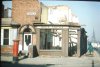
I went to Prince Albert in the 60s/70s. That building was used as a clinic and dentist at the time. I had so many fillings there.This incredible building still exists in Albert Road.
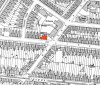
On the map of 1889 it is listed as School Board Offices and on this side of the road there are no buildings between this and the library on the corner of Albert Road and Witton Road.
The map of 1937 lists it as a clinic.
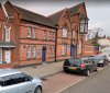
Present day it appears to be used in two parts, for 'Prince Albert Primary School' and The Arches, Pastoral and Inclusion Centre'.
My late father in law was the caretaker there back in 1976..I went to Prince Albert in the 60s/70s. That building was used as a clinic and dentist at the time. I had so many fillings there.
I don't know if you have come across this but it is a useful facility which shows exactly where the expressway was built, just slide the bar at the bottom.Hi there
I am wondering if someone knows where to get an old map of Albert Road, Aston Manor, for around 1920 and or pre before The Aston Express way went through the road. I am looking for a map with the houses on please.
I am looking for 344 Albert Road, as I reckon The Aston Express Way goes very near to where the house stood and would like a map with house numbers on to work this out.
ok thanks for this MikePark road
wow, that's a good utility, not used this before, thankyou for your help.I don't know if you have come across this but it is a useful facility which shows exactly where the expressway was built, just slide the bar at the bottom.
This might be better, the map shows the individual houses, I find the system quite difficult when selecting maps but yes it's brilliant and free.wow, that's a good utility, not used this before, thankyou for your help.
It looks like Express way did go through the house,
cheers