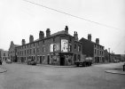
This photo is labelled as at the junction of Adderley Street and Watery Lane..I am very doubtful as to that attribution. I would guess that the photo is from the period soon after WW2. The 1950 map below shows only one building that could be the shop,, but this would not have Adderley road to the left of it (as there is road sign), but Watery Lane. (the road to the right would be Kingston Road).


There is only one junction which would have Adderley Road on the left. This has no buildings in 1950 and on the rather rough 1937 map is shown to be a pub

But we can say it is on Adderley Road
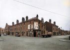
There is only one junction which would have Adderley Road on the left. This has no buildings in 1950 and on the rather rough 1937 map is shown to be a pub
But we can say it is on Adderley Road