• Welcome to this forum . We are a worldwide group with a common interest in Birmingham and its history. While here, please follow a few simple rules. We ask that you respect other members, thank those who have helped you and please keep your contributions on-topic with the thread.

    We do hope you enjoy your visit. BHF Admin Team

Field Gate Farmhouse, Acocks Green

bilsat

master brummie
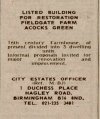
In the Mail today 12th Dec there is story in the old suppliment dated 15th Dec 1977 about the demise of Field Gate Farmhouse and that it was to be demolished, brick by brick, did this happen and if so what happened to the bricks and was it rebuilt?
Also where along Yardley Rd was it?
 
Hi Bilsat,I did have a look for some info re the census etc,but all I could see was Field Gate Cottages,there were 3 of them (if I remember correctly) but I couldn't see a farmhouse! I think I had a look on the Electoral Rolls as well,and couldn't see it,so I didn't post!!:rolleyes:
 
I did a search on google. There is a mention of Field Gate Farm on the BGFL site. But nothing except to say it was Tudor. I think perhaps, Birmingham Library would be a good place to enquire.
 
Hi All.
Your search Suemalings is the right farm as the Mails article said it was of Tudor origin, it just seems strange that a farm and building can vanish of the face of the earth with no trace!
Ladylinda where does the census say the cottages were/are and when?
Thanks
Pete
 
Hi Bilsat,I looked at the 1901 census which shows a place labelled "The Farm" as uninhabited.,then there is a couple of houses,then 3 cottages called Field Gate Cottages,then "The Wharf",then Brighton Place,Yardley Rd,Albert Terrace,Yardley Rd,shop,Sheldon Lodge,then Olton Lodge on the Census sheets.In the other direction were some larger houses.Peoples name at one of the cottages were Thomas and Mary Jones,aged 73. At another the family were Martha Bullock and a William and George Smith and at another was a William and Caroline Heffer or Haffer. I think if someone could come up with a map of the area we could pinpoint it.My maps don't cover that part of Brum.On the 1901 census it was labelled RG13 2922.After looking on the 1891 and 1881 census,I think it was near to the canal not far from Augusta Rd?
Hope this helps!
 
there was an old cottage standing on the canel around that time. I dont know if it was taken down brick by brick or demolished. there,s a pair of semis there now.
 
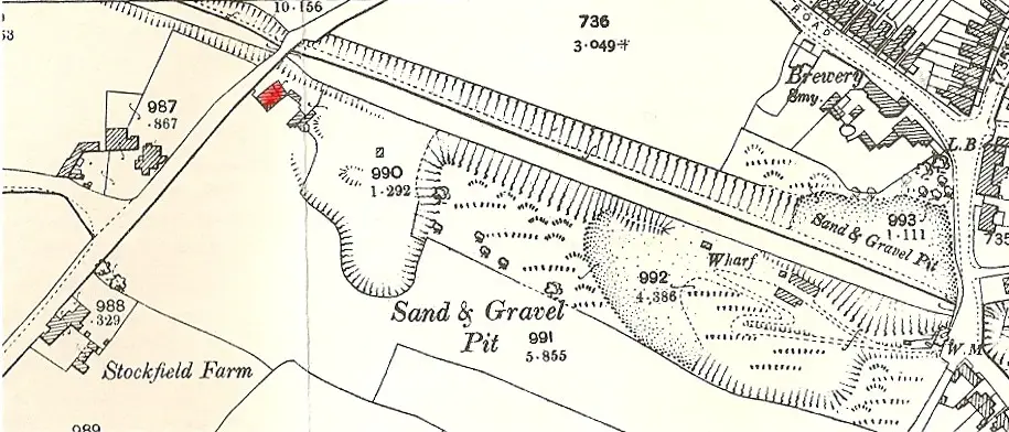
The map c 1912 shows the wharf. Stockfield road is the one coming down on the left, so field gate farm must be the building in red, though it is not named on the 1912 or 1890 maps, or, as far as I can see, in any directory
Mike

fieldgate_farm_c_1912.jpg
 
Fieldgate Farm was on Yardley Road, where Mary's Dog Parlour was. The Farm was a Listed Building, now you can't find anything to do with the Farm, another cover up from Birmingham council.
 
Fieldgate Farm was on Yardley Road, where Mary's Dog Parlour was. The Farm was a Listed Building, now you can't find anything to do with the Farm, another cover up from Birmingham council.
interesting....would anyone happen to know when the farm was demolished and as yardley road is so long could someone pinpoint on todays street view the exact location and i will check my photo files to see if i may have a photo of the farm also where on yardley road was marys dog parlour..sorry i dont know the area well...thanks

lyn
 
Last edited:
 
I think I have located the site but stand to be corrected. I hope member 1Cashy will see this and let me know if I am right.

I followed several clues.
The info in post #10 about Mary's Dog Parlour.
The 1968 phone book entry
1730708986112.png

Plus this snippet from the excellent Acocks Green History website (referred to in post #13 by member Pedrocut)
The whole page on Yardley Road can be seen here
https://aghs.jimdofree.com/yardley-road/

A track led down to Yardley wharf after number 192. The half-timbered Fieldgate Farm was a little way down here. Tree-ring dating suggests it dated from the first half of the 17th century. The name suggests it was a way into the open field called Acocks Green Field. The farmhouse/cottages had a sad end in 1977, being taken apart and the wood being stored at the Museum, despite local protests. The fields for this farm were divided by the canal. The building was divided into three cottages, and at various times housed boot makers and repairers. In the 1960s Mary’s Dog Parlour was in business from here.

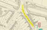
So I located 192 on a map from 1952 and found 196.
Yardley Road in yellow. 192 and the track in blue and the cottages/farmhouse ringed in red.
1952 map.jpg

Street view of 192 and new builds where the yard and cottages/farm were. Small roadway still there. Thanks to Lyn for that link.

 
excellent jan..pretty sure we have the exact location now...i still find it remarkable that as the farm/cottages were still standing in 1977 we cant find any photographs...most odd and of course as they were tucked away at the back of the builders yard easy to demolish without anyone noticing..very sad

lyn
 
Last edited:
Thanks Lyn.
AGHS don't have one on the Yardley Road page so I would think there is no photo
Will see if I can identify it on any censuses.
 
ok jan thanks and i will keep looking for any photos...i was wondering if there is anything else in the newspapers about the sale in 1977 that included a photo...just a thought

lyn
 
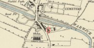
could our britain from above expects have a look at post 16 please to see if an overhead shot is available showing the farm/cottages on that map. which are circled in red...i am now clutching at straws but you never know

thanks

lyn
 
I must say that this site never fails to amaze me! I have walked, cycled, bused and driven past this area hundreds of times, especially around the 60,s & 70,s, and never even noticed what was there! Keep up the great work!
 
I must say that this site never fails to amaze me! I have walked, cycled, bused and driven past this area hundreds of times, especially around the 60,s & 70,s, and never even noticed what was there! Keep up the great work!
dave its no surprise really as you will see from the map the farm'cottages was tucked behind the builders yard so no view from the road i would think...

update..i have now emailed dr mike hodder the relevant information we have to ask him if he has any info regarding the archaeologists survey that was ordered to take place before the farm was demolished...will report back when i know something

lyn
 
Still continuing down Yardley Rd
Lived nearby in late 1960-1970. Had an allotment between Yardley Cemetery and the canal. I did not know of Field Gate Farm but do remember the transport yard on the site. I've seen a photograph of a No11 bus rounding the bend after crossing the canal, maybe on BHF not sure, perhaps farm could be seen on that. Looked on Britain from air without sucess, found a mention on Historic England and also Acock's Green History site still no picture!
 
thanks jim like you we have drawn a blank so far...fingers crossed mike hodder may be able to help us

lyn
 
another snippet from AGHS
Fieldgate Farm east of Yardley Road and owned by William King in the 1840s, was divided by the bend in the canal. There were several buildings along the roadside, and a row of timber-framed cottages set a little back from the road. They stood until 1977, and latterly functioned as Mary’s Dog Parlour.
 
Back
Top