-
Welcome to this forum . We are a worldwide group with a common interest in Birmingham and its history. While here, please follow a few simple rules. We ask that you respect other members, thank those who have helped you and please keep your contributions on-topic with the thread.
We do hope you enjoy your visit. BHF Admin Team
You are using an out of date browser. It may not display this or other websites correctly.
You should upgrade or use an alternative browser.
You should upgrade or use an alternative browser.
Location help: possibly Bordesley ? Tranter's coalyard ?
- Thread starter brummie-007
- Start date
brummy-lad
master brummie
Richard Dye
master brummie
This has become quite a stimulating conversation! While I have no familiarity with the area, the group’s analysis has been quite stimulating! That comment is made in a most positive way.This might help interpretation. The ‘hayloft’ is on the gable end of the building outline in red. The blue structure has a high level opening. Area marked in yellow is a fence. The green building is a type of ‘gatehouse’ to a site of some kind where entrance and exit could be monitored. Tinpot
There is a second lamppost where the vertical red line on the left meets the blue structure.
Unless it's a trick of the camera, it has to be a road with a sharp drop judging by how each of the houses on the left are 'stepped' as you move down along the terrace. This is as well as the clear drop in the road, with the buildings on the right being much, much lower than the buildings on the left.
Also the buildings in the distant background are very high, almost like there's a dip/valley between that position and the foreground. That's why I originally thought this might be close to an embankment.
Also the buildings in the distant background are very high, almost like there's a dip/valley between that position and the foreground. That's why I originally thought this might be close to an embankment.
Im prepared to be shot down in flames on this ! But I'm starting to lean towards Adderley Park. Mainly on the basis of the terrain. Nothing more specific to offer I'm afraid.
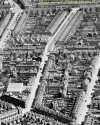
Been all over the area this afternoon (on Streetview) with no joy. So revisited Clive's idea of Bolton Road. I found a 1960s photo. Lots of differences but a fair few similarities. I wondered if the road was being cleared for redevelopment (on the right side in the original photo) which could change the view if houses had been removed ? Obviously, that would make the original photo date to the 1960s and not the 1950s.The lie of the land and the buildings far off in the distance put me in mind of the bottom of Bolton Road, Small Heath as it goes down to Coventry Road. Just speculation though.
The detail on the houses on the left side are a little more ornate, although that could be the angle of the photos and perhaps they were taken from slightly different positions along the terrace. I think the original photo would be further up the Bolton Road hill.
The two lamposts are in a similar position, one having an 's' bend. And there's a bridge, not decorated as such, but it could have been repainted. The cobbles have gone except along the kerbside.
Anyway, I'm still mulling over Clive's idea. Not too sure if its this place, so thanks Clive........ but what a nice choo choo in the photo !


Last edited:
Richard Dye
master brummie
I think you are on to something, I don’t know the area but a lot of what you say makes sense. And yes it is a nice choo choo!Been all over the area this afternoon (on Streetview) with no joy. So revisited Clive's idea of Bolton Road. I found a 1960s photo. Lots of differences but a fair few similarities. I wondered if the road was being cleared for redevelopment (on the right side in the original photo) which could change the view if houses had been removed ? Obviously, that would make the original photo date to the 1960s and not the 1950s.
The detail on the houses on the left side are a little more ornate, although that could be the angle of the photos and perhaps they were taken from slightly different positions along the terrace. I think the original photo would be further up the Bolton Road hill.
The two lamposts are in a similar position, one having an 's' bend. And there's a bridge, not decorated as such, but it could have been repainted. The cobbles have gone except along the kerbside.
Anyway, I'm still mulling over Clive's idea. Not too sure if its this place, so thanks Clive........ but what a nice choo choo in the photo ! View attachment 194589View attachment 194588
View attachment 194590
I think the photo is more likely to be in a street rather than in the coalyard.
The building on the right dies look like a ticket office so it could be near a railway station.
you could well be correct jan because looking at the photo again the children seem to be standing on a pavement ..the pavement looks very much like the one in vivs photo of bolton road. post 56.large slabs and brick edging and a line of old bricks in the road.. hence the lampost
lyn
Last edited:
Brummie007
proper brummie kid
That would make a lot of sense thank youThis might help interpretation. The ‘hayloft’ is on the gable end of the building outline in red. The blue structure has a high level opening. Area marked in yellow is a fence. The green building is a type of ‘gatehouse’ to a site of some kind where entrance and exit could be monitored. Tinpot
There is a second lamppost where the vertical red line on the left meets the blue structure.
That would make a lot of sense thank you
tinpot made a small error brummie007..she was talking about burlington st not road...
lyn
Brummie007
proper brummie kid
thank you noted i have to say this is the best response i’ve had from this i’ve enjoyed reading every post i’ve stumbled onto a fabulous group thank you all
thank you noted i have to say this is the best response i’ve had from this i’ve enjoyed reading every post i’ve stumbled onto a fabulous group thank you all
have you read my post 73 in response to vivs post 66...again guess work but possible your photo was taken in a street or road as suggested by janice
lyn
lyn
Brummie007
proper brummie kid
Yes i did thank you lyn i just wished i knew who where the photo came from i have never saw a photo of my Mom as a child only in her late teens 17 and then when she married at 18 i know it was tough for her & her siblings growing up so she didn’t tell me a lot they was raised by Grandad so would probably of spent a lot of time with him on his rounds
If so, it would date the photo as the latter part of the 1940s. Clothes for children at that time are difficult to date, especially because of war/post-war rationing and handed down clothes etc. The girl's dress looks to me as though it's been hand-sewn, probably made from another dress judging by the bodice. (Looks like a tartan/check material). The cardigan could well be 1940s (possibly with a thin row of fairisle or other pattern). Likewise the boy's sweater could easily be 1940s, it seems to have had the hem removed. I'd say his trousers are definitely handed down.
The style of the pram would fit with the 1940s/50s, as this was a design that was pretty much unchanged for many years into the 1960s and early 70s. The pram handle and brake handle look newish.
The style of the pram would fit with the 1940s/50s, as this was a design that was pretty much unchanged for many years into the 1960s and early 70s. The pram handle and brake handle look newish.
Last edited:
pjmburns
master brummie
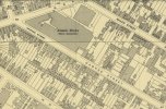
If we go a bit earlier then there were fewer buildings on the 1945 mapA 1950s map of Hawkes Street. Could it be Atlantic Works?


Post #7 here has a photo of the corner with Grange Road, albeit earlier.
We lived in Hawkes street, (off Muntz street) between 1960 and 1967.
I always remember someone being murdered on our front door step, and having to be kept in the house for hours whilst forensics did their bit.
We lived opposite the garage, towards the bottom of the road. (Muntz street end) Winnie and Ronnie George lived next door with their 2 boys, Derek and Paul, and later a little girl, Julie. A few doors away lived a very big family with 12 plus kids, called the Haywoods.
Anybody else out there lived in Hawkes street?
- lerryngal
- Replies: 55
- Forum: Homes Hospitals Workhouses
Last edited:
Radiorails
master brummie
Different street lights there.
just going back to vivs post 66 where she posts the original photo and black and white of bolton road...in the original it does look as though the children are standing on a pavement..then compere the pavement on the black and white..both slabbed both a line of edging bricks and both show the same old cobble bricks near the road...also both photos have the same lamp posts...also here is another photo of bolton road
i am not suggesting that the original photo was taken in bolton road just noting the very similar things as i guess a lot of pavements were like that and probably a lot of streets had the same lamp posts...this could be a mystery we just cant solve for certain.
lyn
.jpg")
i am not suggesting that the original photo was taken in bolton road just noting the very similar things as i guess a lot of pavements were like that and probably a lot of streets had the same lamp posts...this could be a mystery we just cant solve for certain.
lyn
If you go to the top of Bolton Road you can see Holy Trinity Church, Camp Hill. I speculated about this in post # 32. It looks further away on the B&w photo and there are no distinct spires, but that could be the camera angle. Again, speculation.


Last edited:
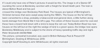
Looking again, this looks to me a very likely position. It's near the junction with Arthur Street. Railway embankment to the right. The curve of the road, in a high position, near St Andrews. Ticks a lot of boxes. The houses to the left look like late early/mid 1970s development, so would fit the timeframe.

Last edited:
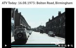
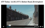
A couple of screenshot from a MACE newsreel, 1973. Link also attached, if you're squeamish about rats, don't watch!

 www.macearchive.org
ATV Today: 16.08.1973: Bolton Road, Birmingham
Tony Maycock report about the poor condition of housing on Bolton Road in Small Heath, Birmingham which has been described as the worst street in the city.