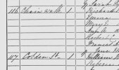
In the 1861 census I have relatives in Cobden St, Aston.
The adjacent streets on the census return are Chain Walk, (Lower) Wilton St and Lozells Rd which all still exist
I have searched on maps of the period but I can't find Cobden St which has about twenty houses listed on the census.
May be my dodgy eyesight, but any help would be appreciated.
The adjacent streets on the census return are Chain Walk, (Lower) Wilton St and Lozells Rd which all still exist
I have searched on maps of the period but I can't find Cobden St which has about twenty houses listed on the census.
May be my dodgy eyesight, but any help would be appreciated.