• Welcome to this forum . We are a worldwide group with a common interest in Birmingham and its history. While here, please follow a few simple rules. We ask that you respect other members, thank those who have helped you and please keep your contributions on-topic with the thread.

    We do hope you enjoy your visit. BHF Admin Team
  • HI folks the server that hosts the site completely died including the Hdd's and backups.
    Luckily i create an offsite backup once a week! this has now been restored so we have lost a few days posts.
    im still fixing things at the moment so bear with me and im still working on all images 90% are fine the others im working on now
    we are now using a backup solution

William Lench

Dennis Williams

Gone but not forgotten
Now lets go right back to a Middle Ages benefactor…the only one of many folk whose charity is still going strong. And, as per, one thing leads to another…as we shall see…

Lench Blue Plaque.jpg

In 1525 William Lench, a tanner by trade and living in Moor Street, then called Mole Street, decided to leave his wordly wealth to nineteen of his friends by a Deed of Gift dated 11th March 1525. His will of 24th March 1525 asked that the monies be used for works of charity.


In a Declaration of Trust dated 1540, twelve Trustees were appointed to apply and distribute the income and profits. These twelve good men decided that the money should be spent in two ways:


1.
 in repairing the ruined ways and bridges in and around the town of Birmingham
2. in bestowing the same on the poor living within the said town, where there was the greatest want
.

Lenchs Trust Document.jpg


Until 1838 and the incorporation of the city of Birmingham the income of the Trust was used for these two purposes. After the incorporation the Trust concentrated all its resources on looking after the poor, leaving the council to look after the roads and bridges.

The care of the poor and needy was provided by housing (almshouses) and the payment of stipends (pension). The foresight of Trustees is very apparent, if one considers that state pension provision did not begin until 1911.


The first reference to almshouses in the Trust's history is to Digbeth Almshouses in 1639. This confuses me a little as I cannot find any reference to these buildings named specifically in any of my history books. It could be that they are the on William Lench’s original land site in Mole or Moor Street? Consider Elizier Edwards’ account:
Near the spot where the Public Offices now stand was a large open space, called Green-tree-yard, so named from an ancient tavern called the Green Tree which stood there. The yard was for centuries used as a timber yard. This property, with a small plot which now forms a portion of the coffee room and bar of the Woolpack Hotel, and With other property, now the site of the newest part of the Public Office, was given by the Shyltons to charitable purposes, part of it going to the Guild of the Holy Cross.

Nearer the Bull Ring was property of the Clodshales, which they gave to form a charity, and adjoining this was land belonging to E. Ardenne's chantry. On the opposite side of the street was property left by one Ward for charitable purposes, while still further from the Bull Ring were other lands given to the Guild. The Woolpack, as it originally existed and before its conversion to a tavern, was the residence of William Lench, and there he died, having previously made the celebrated bequest which has for more than three centuries so benefitted the town. The house itself - subject to its occupancy for life by his widow, was included in the bequest and is still held by "Lench's Trust."


Elizier Edwards 1879

Woolpack Hotel Moor St 1949.jpg Woolpack Inn Moor St Showell.jpg

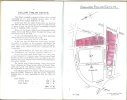
Anyone care to comment? And, however, I CAN find reference to a Lench’s Trust site in a map of 1689. Seemingly, an original Lench’s Trust Houses stood in Dudwall Lane (Dudley Street) - Pinfold Street in the City Centre until that site was sold to the London & North-Western Railway in 1846 as part of the New Street Station development.

Plan of old Meeting House 1689.jpg

to be continued....
 
Last edited by a moderator:
There were lots of other Almshouses built over the years...Showell says: In 1688 the Trustees built another group at the corner of Steelhouse Lane and Lancaster Street in "rural surroundings", with "an extensive and beautiful view of the country".

These were later replaced, as Showell also says: Almshouses for Lench’s Trust were built in Steelhouse Lane in 1764. In later years other sets of houses have been built in Conybere Street, Hospital Street, Ravenshurst Street, and Ladywood Road, the inmates, all women numbering 182. Jas. Dowells Almshouses in Warner Street, consisting of 20 houses and a chapel known as “Retreat” were built in 1820. Mrs Glover’s Almshouses in Steelhouse Lane for 36 women were built in 1832. Jas. Lloyds 24 Almshouses were erected in Belgrave Street in 1868.

Steelhouse Lane Lenchs Trust Houses.jpg

Since those beginnings the Trust has gone from strength to strength. These early almshouses have long since demolished with new ones taking their place - the latest one as new as 2011!


Ravenshurst House.jpg

From William Dargue: Ravenhurst Almshouses are in Highgate, a double-fronted building with Dutch gables which was in existence by 1731 as a private dwelling. They are now Grade II Listed. In 1849, just after they were changed to Almshouses, forty six poor aged women were in residence cared for by Matron Ann Starling; residents paid 4 shillings a week for their lodging. During World War 2 a German bomb hit the almshouses killing one of the residents; the buildings were repaired in 1948. Ravenhurst Street probably represents its long drive. There were extensive out-buildings and a large orchard.

Charles Pye described the house in his Description of Modern Birmingham: You proceed through Deritend, up Camp-hill, and when near the summit, there is on the right hand an ancient brick building, called the Ravenhurst, the residence of Mr. John Lowe, attorney, who is equally respectable in his profession, as the house is in appearance.

The Ravenhurst estate was adjacent to Henry Bradford's estate, which had been laid out from 1767. Although almost all of the original development has long gone, some handsome early Victorian villas survive along the Moseley Road opposite Highgate Park.

Also still standing is The Moseley Arms at the corner of Ravenhurst Street and the Moseley Road. It was certainly in existence by 1854 and had its own brewery in buildings to the rear. After supplying other local outlets for a number of years, the brewing side was bought out by a larger brewery and brewing here ceased about 1900. By 1881 the pub was also offering hotel rooms. The Moseley Arms is currently a noted live music venue.


Old Moseley Arms  Tindall St Balsall Heath.jpg


In fact I think you can see the old Ravenshurst houses in Westley's print of 1732...

Westley---East-Prospect-of-Birmingham-1732.jpg
 
Last edited:
Now here's the rub. Here’s the odd connection I mentioned at the start. Last week I chanced upon a post on another Thread by Rupert, where he linked us to a Print Sellers in Oxford who also had some Birmingham Lithographs for sale. One was a fascinating old print of Pinfold Street. Now if you remember the 1689 Map below, it shows a Lench’s Trust plot, and you will see it was in Pinfold Street.

Pinfold Street.jpg Plan of old Meeting House 1689.jpg Pinfold St Peck Lane 1731.jpg

The date of the print is 1875 but the drawing is obviously from the 1700s at least. So the Lench’s Trust plot, and any Alms Houses thereon, may be shown on the print. As is of course, and maybe the notorious Peck Lane Prison, which was somewhere around there well before the Froggery was demolished. There's no orientation info attached anywhere, so GOK which side of the Street is which, but the BOTTOM one shows a corner with what could be the Prison in the background to me?

Received wisdom from various sources says: Peck Lane Prison The prison on the corner of Pinfold Street and Peck lane consisted of two cells and a courtyard of 25 sq ft. There were times when there were 100 prisoners crammed into this dark, foreboding place.

Well I can dream can’t I? What does the team think? Are either the prison or Alms Houses depicted? It's a cracking drawing in any case...


peck lane prison.jpg
The Prison

Pinfold Street now.jpg
Pinfold Street today
 
Last edited:
Might have completely got the wrong end of the stick Dennis, but this is how I see it.

ImageUploadedByTapatalk1362002492.062087.jpg Blue dot = the prison, black dot = Lench's Trust You can make out a courtyard near the blue dot.
ImageUploadedByTapatalk1362002560.939068.jpg Blue dot = the prison, black dot = Lench's Trust

The drawing of Peck Lane Prison looks like it would have been drawn from The Pinfold i.e the artist had his back to The Pinfold. So if we can pinpoint a pinfold on the drawing of Pinfold Street, Peck Lane Prison and the Lench's Trust house must be opposite or thereabouts.

Even if all this sounds like complete tosh I must say just having a good look at the two maps in this way has made me realise exactly where the prison was! I've realised the lane in the Peck Lane Prison drawing must be looking up towards New Street. I'd always thought that the lane to the left of the prison was going away from New Street. If this all sounds completely whacky, I've still enjoyed reading about the almshouses and looking at the various docs! Thanks. Viv.
 
Chewed this over a bit more and I think the Pinfold Street drawing shows Peck Lane Prison (blue dot) Lench's Trust (black dot) and The Pinfold (red dot). But on the other hand ........ !!! Viv
ImageUploadedByTapatalk1362005120.080439.jpg
 
s Retreat 21 houses and a chapel built by James Dowell.jpgHi Dennis going back to post #115 a pic of Dowell's Retreat Warner Street 21 houses and a chapel for the use of old and poor women built by James Dowell in1842
 
Superb pic bernie...and is that a tea cosy on her head? Those old entrepreneurs and benefactors would LOVE the new Bankers' codes of conduct wouldn't they?...
 
Last edited:
I once had the opportunity to purchase a small booklet which was apparently issued to people for a
"Perambulation of the Trust", presumably by the Trust members in 1923.

Lench's'  trust.1.jpgLench's'  trust.2.jpgLench's'  trust.3.jpgLench's'  trust.4.jpg
 
There follows plans and a short description of each site
Hospital Street

Lench's trust 5.jpg

Here is the court on an 1880s map

map 188s showing Lenches Trust Hospital St.jpg
 
hi mike i knew of the lenches almshouses in hospital st a lot of my ancestors lived around there for many years but the info you have posted about william lench tanner and the maps are most interesting and i certainly did not know that he went that far back ...thanks

lyn
 
Princip St
I am not clear where thi was, apart from that it was the north sde, between the street and the canal. I seems to be owned l\nd leased out , and not used for housing by the trust

Lench's'  trust.7.jpg
 
St Mary's Estate
A large area of land, much changed over the years. Of particular interest to the forum is that the Bull pub , at leats in 1923, appears to be leased from the Trust. the wording and map do not seem to completely agree, as the map refers to an area in blue, and there is none ij blue on this map. I am glad for the starred note, as, otherwise, my mind might have run riot as to the meaning of "the making of love days amongst Birmingham men"

Lench's'  trust.8.jpg
 
Woodcock Croft Estate

A large area originally all owned by the Trust, but areas later purchased by the council

Lench's'  trust.9.jpg
 
Dale End
An area then part of Gaskell & Chambers bar fitting business, but now not distinguishable on the ground. Note {For comparing to present map or Google turn 180 degrees)

Lench's'  trust.10.jpg
 
Allison St

I am a little confused by this as it implies that allison st was wisened in the 1920s. Had not heard that mentioned before when we were considering the site south of Well st. that would also imply that the building to the north of well st was post 1920 , or was pre 1920 but had been cut in half. there do not seem to be any visible signs of this

Lench's'  trust.12.jpg
 
Ravenhurst St and Stratford Place

Text describes colouring that is not present on this item, but I think the places concerned are clear. The Almshouses are still there, though not nos 32 & 33, nor the Stratford Place houses

Lench's'  trust.14.jpg
 
Sparkbrook Estate
I am not clear if the houses on Farm Road between Grantham and Gladstone road are still there, though heavily modernised, or whether they are completely new. No others remain of these on the plan

Lench's'  trust.15.jpg
 
Moesley Estate
The houses on Edgebaston. Alcester and Caroline roads appear to still be there, together with six of the eight on Augusta Road

Lench's'  trust.16.jpg
 
Kingswood Estate

The majority of the houses in this estate still remain . according to Streetview, though obviously modernised

Lench's'  trust.17.jpgLench's'  trust.18.jpg
 
Horsefair

Lench's'  trust.20.jpg

Position shoen on this 1880s map

map 1880s showing the Lench's Trust property in the Horsefair.jpg


Now seems to be part of a car park and some grassy area
 
Blucher St
The site of the synagogue.
Lench's'  trust.21.jpg


I was a little confused at first by ellis St, but the 1880s map shows that Ellis St once had a slightly different route

map 1880s site of Lenches trust Blucher st.jpg
 
Back
Top