-
Welcome to this forum . We are a worldwide group with a common interest in Birmingham and its history. While here, please follow a few simple rules. We ask that you respect other members, thank those who have helped you and please keep your contributions on-topic with the thread.
We do hope you enjoy your visit. BHF Admin Team -
HI folks the server that hosts the site completely died including the Hdd's and backups.
Luckily i create an offsite backup once a week! this has now been restored so we have lost a few days posts.
im still fixing things at the moment so bear with me and im still working on all images 90% are fine the others im working on now
we are now using a backup solution
You are using an out of date browser. It may not display this or other websites correctly.
You should upgrade or use an alternative browser.
You should upgrade or use an alternative browser.
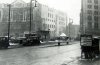
Where in Birmingham was this taken ??
- Thread starter ragga
- Start date
Lloyd
master brummie
Just a couple of Queries Photo 2 wasn,t the Old Henrys on the corner of Martineau St (the new one was in Union St )so the bus would have been in Bull St.
Photo3 I agree with your location but what was the Hall Green bus be doing down this end,it looks like it,s carrying passengers.Dek
Yes dek, a bit of irrational thinking there on my part. The new Henrys was Union Street and it's the first name that came to mind.
Newton St - I'm not sure, but at that time (note Gas light on pavement) there was a lot of redevelopment going on, part of the proper route might have been temporarily closed.
keegs
master brummie
Hiya,I think you are right,But It's Garrison Street & Midland Street where the bridge crossed.Ragga
i'm not 100% certain, but thibk no 2 may be the junction of Garrison Lane & Midland St, which would make the pub the Queens Head. If so the pub was there in a derelict state a few years ago, as i remember seeing it often from the train, but was demolished a few years ago. The approximate view now would be at https://maps.google.co.uk/maps?q=Mi...=UTARNI0ZSalAsEuQOgpCNg&cbp=12,294.92,,0,0.07
Mike


DavidGrain
master brummie
Do you think the girl on the left is sending a 1953 text message? LOL
cookie273uk
master brummie
I can certainly remember that YMCA building, have actually been inside more than once but for the life of me cannot remember which street it was in. Eric
Ray Griffiths
master brummie
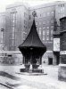
Great Picture Ragga I remember it well the morning of the bombing the area was still burning.
There used to be a Cafe over the roadwhich wasn't hit, Peacocks was round the corner into the Bull Ring, Times Furniture Shop was next to the space of the Co-op.
To the left of the YMCA was a 1000 lb bomb shell which had been converted to a large money box for donations can't remember what it collected for, it end up in enterance Hall Of Nechells "B" Power Station,
Wonder what has happened to it it was painted pillar box Red.
Ray
Ray Griffiths
master brummie
Hi lloyd.
Yes it was in the old Market Hall before it was demolished, then I think it was moved to then Big Top Site next to the YMCA in picture.
I expect these days it would have disappeared over night for scrap.
That part of Birmingham used to be a very important area for travel with Worcester \street across the way , Midland Red booking office and entrance to th Queens Drive.
This was the old Birmingham I used love with it's history and the small alleyways leading to out of the way shops, Hitler done use no favours.
Ray


Ray Griffiths
master brummie
Hi Lloyd.
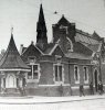
It is as you say the Danish Bacon Co. Ltd both the white building & the brick built round the corner.
Vauxhall Street ran from 41 Stafford Street to Gem Street, James Street ran from 2 Brook Street to Vauxhall Street.
It is as you say the Danish Bacon Co. Ltd both the white building & the brick built round the corner.
Vauxhall Street ran from 41 Stafford Street to Gem Street, James Street ran from 2 Brook Street to Vauxhall Street.


Second photo
Judging by look of photo I guessed it was around 1930s. In 1933 there was Sealey Jesse, newsagt. 89 Beechwood rd. King's heath. Directory does not allow me to see if this was on a corner, but streetview seems to be the same, but no longer a shop at https://maps.google.co.uk/maps?q=Be...noid=Ez3bfrkMiAiaYUS2lrm3wA&cbp=12,111.1,,0,0
Judging by look of photo I guessed it was around 1930s. In 1933 there was Sealey Jesse, newsagt. 89 Beechwood rd. King's heath. Directory does not allow me to see if this was on a corner, but streetview seems to be the same, but no longer a shop at https://maps.google.co.uk/maps?q=Be...noid=Ez3bfrkMiAiaYUS2lrm3wA&cbp=12,111.1,,0,0

yes phil
coming up the aston road north from the aston cross passing gosta green ; drinking trough and making there way back to duke street
and around the back and hat big bulding you see was the nurses quarters for staff at the old general hospital;
and when the big fire across the rd years later from central ;fire started it almost engulfed that block
but with the fire station next door and the factory of samuels they openened there doors and stood facing it as the flames was coming across the rd to the block of nurse they had to be evacuated ;
best wishes to you all astonian;;

 ride: but i could be wrong .