motorman-mike
Brum visitor who stayed.
Is it Raddlebarn Road?


If you look at the buildings to the left of the Wheatsheaf in the original photo, and then compare them with the buildings in the photo I have posted you will see that they are the same and therefore the only possible location the photo could have been taken is from the top of Severn Street just before the dog leg turn into Blucher Street.
Phil
Well done Astonian, very close mossg! :encouragement:
3176 (MOF 176) - The Brook Cafe was at 70, Hockley Hill - almost at the bottom of the Hill, I'd guess the bus was heading back to depot.
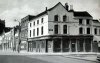
2118 (JOJ 118) - As Astonian says, Union St with the old Henrys store in the background.
1657 (HOV 657) - Newton St, between Steelhouse Lane (to the left of the photo) and Corporation St (behind the photographer). The buildings are still much the same, but the street is now a cil-de-sac, closed at the Corporation St end.
I didn't really know the area in those days, but here is a copy of Astoness' map with the Bartons Arms marked (Red) and the original 33 route (Green).
I'm assuming Alma Street had closed and the diversion took it further along Birchfield Rd to be able to access Summer Lane.
The building seen side on looks like a cinema, there is some sort of sign high up on the front (which we can only see the side of) but I do not recognise it.
The early Indian Restaurant mentioned was the Shah Jahan, on the corner of Stafford St and Coleshill St, seen behind the bus in the other photo below.