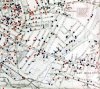
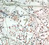
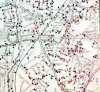
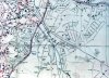
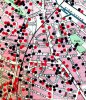
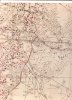
Dear Birmingham History Members, I was wondering if it is possible that someone might have a copy or any maps showing where the bombs fell over Birmingham & Surrounding areas during the Worlds Wars. I seen the map on Who Do You Think You Are not so long ago and never knew it existed. Any
mappings of where the bombs fell would be very grateful please and thank you")
The main areas of interest would be Handsworth, Aston, City Centre, Sheldon/Yardley, and Kings Heath/Moseley. But any other districts would be highly appreciated too for my keepings
Kindest Regards
Andrew
mappings of where the bombs fell would be very grateful please and thank you
The main areas of interest would be Handsworth, Aston, City Centre, Sheldon/Yardley, and Kings Heath/Moseley. But any other districts would be highly appreciated too for my keepings
Kindest Regards
Andrew
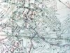
![bombmap Map Birmingham bomb map[1].jpg](/forum/data/attachments/18/18188-a042cb0ce3f4e086e0fe0ed61101a595.jpg)