• Welcome to this forum . We are a worldwide group with a common interest in Birmingham and its history. While here, please follow a few simple rules. We ask that you respect other members, thank those who have helped you and please keep your contributions on-topic with the thread.

    We do hope you enjoy your visit. BHF Admin Team
  • HI folks the server that hosts the site completely died including the Hdd's and backups.
    Luckily i create an offsite backup once a week! this has now been restored so we have lost a few days posts.
    im still fixing things at the moment so bear with me and im still working on all images 90% are fine the others im working on now
    we are now using a backup solution

Unused railway "arm" in Digbeth.

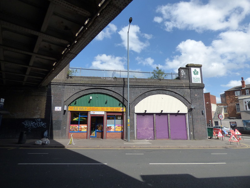
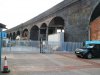
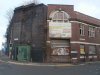
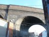
The tunnelling to what became Snow Hill was I believe contemporary with making the viaduct to Curzon Street. It was the railway politics that influenced the unfinished state of the viaduct railway. The making of the extension to New Street from beside Curzon Street came later.
 
There was only a few months in it. Snow Hill opened 1st October 1852 and New Street 1st June 1854. The planning and building would have been going on at the same time as it takes several years to get the plans through parliament and then the actual construction. I have been told that dual gauge track for both standard gauge and Brunel's 7ft gauge had been found on the viaduct but I have never seen any photographs.

New York's High Line which is a disused railway viaduct formerly carrying a freight line through Manhattan's West Side has become a linear park and is greatly appreciated.
 
On the Coventry Road, not far from Bordesley Station, some of the arches are being used for shops, although only one is in use. Did there used to be a bridge next to the current one on the Bordesley Viaduct?

 
If I've got my bearings(Bordesley Station behind the camera)those same arches were used as a car workshop in 1950's by Cole's. Certainly now doesn't look big enough, not even any drop kerbs.
 
There were sidings at Bordesley Station for cattle for the markets as has been mentioned either in this thread or others on the forum. There was also the link to the unused viaduct to Curzon Street. These would have required a wider bridge than the present one over the Coventry Road. I have been told that within living memory there were still some broad gauge rails on that viaduct and sidings long after the broad gauge was taken out of use.
 
If you look at the maps for c1915 and c1951, then it does appear that the bridge was widened between those dates, but not at the point over those two arches.The google view from above today shows the same configuration. I would guess that originally they palnned to have another bridge and allowed for it, but it never was built as the viaduct was never used for through trains only cattle and storage.

google view of track by bordesley station.jpg map c 1915 bordesley station.jpg map c 1951 bordesley station.jpg
 
Mike, Am I reading your two maps correctly? Do they show that the station migrated from N of Coventry Rd to S of Coventry Rd?
 
Yes Jim. It looks like it happened before the c1937 map. the Warwickshire railways site does not make it clear that it moved (https://www.warwickshirerailways.com/gwr/bordesley.htm ), but states that "As part of the extensive upgrade to the route in to Birmingham, which saw the construction of Moor Street to handle local passenger services, Bordesley station was upgraded to a two-island platform facility, with one island handling local passenger services to and from Moor Street and the other handling traffic to and from Snow Hill. "
 
Bordesley Station opened 7th March 1915 replacing previous station which closed the same day.

Date corrected form 2015 to 1915
 
I understand that Carl Chinn on his guided walks states that the Viaduct from Bordesley Street to Curzon Street never had a train work along it. Whilst it is probably fair to state that a train never covered the whole length, apart from may be a contractors train, the section from Bordesley to Liverpool Street had track, a double line, which first was associated with the Goods Depot and later with the cattle dock. I recall seeing a 9F 2-10-0 at the head of waggons on the viaduct in the 1960's.

A question that needs to be resolved is whether there was an arch that spanned Great Barr Street, or whether the contractors building this viaduct were told to stop before completion.

The alignment of this viaduct was intended to meet up with the Grand Junction Railway, who, at first, helped to promote the Birmingham & Oxford Junction Railway. This state of affair had been the result of high freight charges imposed by the London & Birmingham Railway.

It would appear the need for moving goods, was not only to influence the GWR expansion into South Staffordshire, but also another the Oxford, Worcester & Wolverhampton, then a separate undertaking.
 
Looking at the c1889 map, what interests me are the train tracks marked, especially a small length right at the far end where there are a twin set of tracks marked for a short distance, isolated from the rest
map c1889 unused digbeth viaduct.jpg
 
I am attaching the official Network Rail track diagrams of the sidings that are now being advertised as mentioned in the posting by Alan (RadioRails). I have turned the copy upside down to bring the north round to the top of the page. The sidngs mentioned are the dotted lines to the left of the diagram.

EDIT sorry that does not appear to show. I attempted to upload it as a .docx file but that was refused so I have tried to upload it as a .pdf file but that does not seem to work

CORRECTION It has appeared as a download
 

Attachments

  • Bordesley sidings.pdf
    255.1 KB · Views: 50
Last edited:
With regards to the 1889 map, yes, this and earlier maps indicate there were various lengths of track, that may or may not have been associated with the GWR construction period.

It is a useful map as it shows the viaduct complete.

The Bordesley sidings refer to the extensive group of sidings and land that extends to Small Heath station. The GWR had a locomotive shed there before Tyseley was constructed.
 
A few photos taken around the 'arm' on Sunday. Some repairs to the brickwork have taken place on one of the arches. The original columns are still in place but the tie beams are showing signs of wear. When we were there a pigeon flew out of the hole.
Gentleman's facilities on the corner of Gt Barr St & Liverpool Street showing signs of wear. Can anyone tell me what the adjoining building was originally please?
These lights are outside Digbeth Dining Club - I haven't eaten there yet but my friends have. It was closed when we went past or we might have been tempted.
 

Attachments

  • Cerros Yard.JPG
    Cerros Yard.JPG
    815.3 KB · Views: 33
  • Gt Barr St & Liverpool St.JPG
    Gt Barr St & Liverpool St.JPG
    725.9 KB · Views: 44
  • Lights.JPG
    Lights.JPG
    952.1 KB · Views: 32
Padstones on the viaduct. They look like window boxes don't they with the plants growing out of them!

Sorry, I meant to post this on the viaduct 'arm' thread. Could someone move it for me please?
 

Attachments

  • Pad Stones.JPG
    Pad Stones.JPG
    454.9 KB · Views: 25
Last edited:
Lady P
The whole building is 54-61Liverpool St. It is marked on maps as warehouse, and Kellys gives multiple occupants at the same time, none of which are accorded numbers, but if the order of the occupants listed is as position, then th enearest to the viaduct was lyons tea merchants in 1973
 
This is taken from RailMapOnline. It shows the viaduct as being completed only as far as Liverpool Street. If this is not correct I do not know the source of the website owners information but he has corrected errors in the past which I have pointed out to him.
Bordesley old rail mao.png

Interested to see that ASDA Smal Heat could have been railway connected.
 
A few photos taken around the 'arm' on Sunday. Some repairs to the brickwork have taken place on one of the arches. The original columns are still in place but the tie beams are showing signs of wear. When we were there a pigeon flew out of the hole.
Gentleman's facilities on the corner of Gt Barr St & Liverpool Street showing signs of wear. Can anyone tell me what the adjoining building was originally please?
These lights are outside Digbeth Dining Club - I haven't eaten there yet but my friends have. It was closed when we went past or we might have been tempted.
wonder if nationwide was told to remove billboard?
 
been following tracks on google the duddeston line went underground under moor st. and did connect to small heath line
at the freightliner depot landor st
 
Does anyone remember NEW ENGLAND which was just past Adderley Street coming from town.

Funnily enough I do remember the phrase New England and what comes to mind is a pub on a corner. I expect it was on the forum somewhere as I can't think where else it could be. I'm sure it was taken in Digbeth.
 
It was a small cul-de-sac just past Adderley street coming from town, had a few houses, it was where TESLA is now.
 
Last edited:
been following tracks on google the duddeston line went underground under moor st. and did connect to small heath line
at the freightliner depot landor st

Perhaps this diagram dated 1915 will help

Birmingham 1915 Railway diagram.jpg

To get from Duddeston top centre on the red (LNWR) line you would have to reverse somewhere between Proof House Junction and New Street Station then take the green (Midland) line at Grand Junction through St Andrews Junction and Bordesley Junction to get to bottom left at Small Heath on the yellow (GWR) line. Note this is a diagram not geographically accurate.
 
Noticed an abandoned overgrown platform near Bordesley Station. Trains stopping on a Saturday afternoon to let Birmingham City FC fans off for the walk to St Andrew's.

 
Back
Top