As I remember it, the Traf was getting a reputation for drugs (as were several other bars in Moseley) so they closed it down for a while. At least it's open again. Although all I saw in a brief visit before the virus happened was one bar (the one on Trafalgar Road), I don't think any of the older clientele were still about (none of them seemed old enough) and there seemed to be less of it.Really enjoyed reading this. What a lot of info & history. Sadly "The Trafalgar" has been renamed "The Patrick Cavanagh". Not sure why but I can't help but feel another small piece of Moseley's history gone.
-
Welcome to this forum . We are a worldwide group with a common interest in Birmingham and its history. While here, please follow a few simple rules. We ask that you respect other members, thank those who have helped you and please keep your contributions on-topic with the thread.
We do hope you enjoy your visit. BHF Admin Team -
HI folks the server that hosts the site completely died including the Hdd's and backups.
Luckily i create an offsite backup once a week! this has now been restored so we have lost a few days posts.
im still fixing things at the moment so bear with me and im still working on all images 90% are fine the others im working on now
we are now using a backup solution
You are using an out of date browser. It may not display this or other websites correctly.
You should upgrade or use an alternative browser.
You should upgrade or use an alternative browser.
Trafalgar road moselely
- Thread starter morris
- Start date
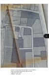
Thanks for the information and quick response (I only asked the question at 11pm last night!) So, if the houses were still there in 1946 I wonder how the land occupied by about 5 or 6 houses was acquired to become a small park? Upon further investigation It seems my ancestors lived at number 39, not 37, and another relative lived at Trafalgar Cottage, Trafalgar Road.The aerial view below was taken in 1946 and shows Trafalgar Rd running from Woodbridge Rd at the bottom of the view to the top where it turns left towards Alcester Rd. The view is not very high resolution but no houses appear to have been demolished by bombing in WW2.
View attachment 160138
for comparison .... a similar aerial view of the area today.
View attachment 160139
Thanks for the quick response to my question. I’m wondering how they acquired the land for the park as they’d have had to knock down 5 or 6 houses and clear the site.Hi Bicko, welcome to the forum. There are a number of possible expiations to your question about house numbering. Bombing in WWII could be a reason. Birmingham was heavily bombed in WWII.
Its looks like there were houses all the way along Trafalgar Road prior to the bus depot being built too.
This link to Side by Side map’s is a always a good resource for research.
oldMohawk
gone but not forgotten
For information, the website link below shows that a man was injured at 56, Trafalgar Road during a heavy air raid on 3rd December 1940.
The above link appears to have gone offline so use the one below
Last edited:
Again, there are a number of possible explanations. A lot of the local houses were built and owned by private landlords and trusts. The Barber Trust was one social landlord as is the Bournville Trust.Thanks for the quick response to my question. I’m wondering how they acquired the land for the park as they’d have had to knock down 5 or 6 houses and clear the site.
Birmingham Council acquired a number of these houses from some of these trusts post WWII and had to do some significant modernisation to some. Others it was more cost effective to demolish them.


I Am Nico
master brummie
If it is like Parkhill around the corner, one was in a bad state, it was so big they demolished it and built Alexander House, names after a friend of my parents. One was shored up for years and years. Being so big they were divided an re numbered. This may have happened in Trafalgar Road.Hi Bicko, welcome to the forum. There are a number of possible expiations to your question about house numbering. Bombing in WWII could be a reason. Birmingham was heavily bombed in WWII.
Its looks like there were houses all the way along Trafalgar Road prior to the bus depot being built too.
This link to Side by Side map’s is a always a good resource for research.
pjmburns
master brummie
1890s map - the red dot marks Trafalgar Cottage which is named. Looks as if it is just north of Harrison's Pleck on modern mapsDoes anyone know why the house numbers (according to Google Maps) stop at 27 and the restart at 43? This is the site of Trafalgar Road park now, but according to my family research in the late 1800's my relatives lived at number 37 and had done for a few decades. Were a few houses bombed in WW2 perhaps? Another member of my family lived at Trafalgar Cottage, Trafalgar Rd, but I've no idea where that was.

Roger Neill
New Member
That's so interesting, finona. My grandfather was Fred Parsons.My grandparents certainly weren`t wealthy! Grandpa was one of the Randalls of Randall Bros. and Parsons on Smithfield market. 104A was a fair sized semi with a large garden and orchard, there was a strip of land (track?) at the side leading I think, to a junior school.
Such a shame the original frontage has been "modernised" as I think it`s arts and crafts and am just curious to know when it was built
Jana
New Member
I know nobody has posted here for a while but the answer to the disappearing houses questions would likely have been Birmingham City Council's drive to increase affordable housing in the area. They took out whole rows of houses and created the small side streets and more modern looking housing on the land
Jana
New Member
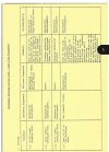
I don't know if these will be legible. Housing plans from 1977 which show which houses were to be demolished and which areas redeveloped.
I am currently changing number 102 from 4 flats back into a family home and am trying to find out as much as I can about the street's history. If anyone lived in 102 past WW2, please let me know. I'm working on a house genealogy.
I am currently changing number 102 from 4 flats back into a family home and am trying to find out as much as I can about the street's history. If anyone lived in 102 past WW2, please let me know. I'm working on a house genealogy.