• Welcome to this forum . We are a worldwide group with a common interest in Birmingham and its history. While here, please follow a few simple rules. We ask that you respect other members, thank those who have helped you and please keep your contributions on-topic with the thread.

    We do hope you enjoy your visit. BHF Admin Team
  • HI folks the server that hosts the site completely died including the Hdd's and backups.
    Luckily i create an offsite backup once a week! this has now been restored so we have lost a few days posts.
    im still fixing things at the moment so bear with me and im still working on all images 90% are fine the others im working on now
    we are now using a backup solution

Trafalgar Rd - Nechells

chocks2

master brummie
A friend of mine has been doing a family search and he came across an old map in B'ham Library dated c1813. He did a quick pencil sketch of the map and when I looked at it there was a road called Trafalgar Rd running parrallel to Long Acre and Nechells Park rd somewhere around where Cook Street is now.
I've looked on several maps and can find no evidence of this road. Presumably it would have been post 1805.
Can anyone provide evidence of its existence. If so, Why and when did the name change, or was the road totaly removed to make way for new housing or whatever.Or was it just a mistake on the map?

Its puzzled me!


Chocks
 
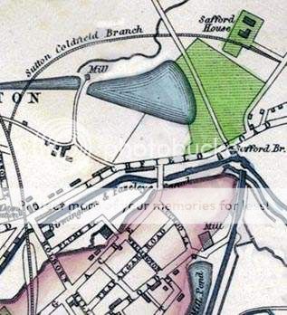
what about this
Salfordhouse2.jpg
 
Thanks Dek. I notice also that Eliot Street was Wellington Place so I wonder when and why the names changed. Do you know the date of your map Dek?
 
I can't find Wellington place mentioned in that place. Up to just after 1900 it was called Hutton St, and it first appears in the directories as that in 1879. Before that there is no mention of either running off long acre. this may be because it was not Birmingham. but Aston
 
Strange one is this eh? It clearly shows Trafalgar Rd and Wellington Place on the map so something must have happened for them to change names.
 
There appears to be quite a few anomalies on the map we have Cuckoo Lane as well but what has caught my eye is Safford House and Safford Bridge could these be spelling errors?Dek
 
I've seen that one mike but it doesn't say why Trafalgar and Wellington (and all the others mentioned) changed or when for that matter. Although that does prove that Cuckoo Road was formerly Cuckoo Lane.
 
That helps Mike because if you view the 1898 map Cook Street and Eliot Street appear so the change took place sometime in that 30 year span. Crompton rd also appears so presumably a building programme took place within that time period. Cheers for the info guys

Chocks
 
bringing this thead to top as it could explain where trafalgar road was in nechells..
 
Back
Top