• Welcome to this forum . We are a worldwide group with a common interest in Birmingham and its history. While here, please follow a few simple rules. We ask that you respect other members, thank those who have helped you and please keep your contributions on-topic with the thread.

    We do hope you enjoy your visit. BHF Admin Team
  • HI folks the server that hosts the site completely died including the Hdd's and backups.
    Luckily i create an offsite backup once a week! this has now been restored so we have lost a few days posts.
    im still fixing things at the moment so bear with me and im still working on all images 90% are fine the others im working on now
    we are now using a backup solution

Then & Now

Phil

Gone, but not forgotten.
This has been tried here a couple of times previously, but it seems most of the photos were lost when the site was hacked. As I have previously done this sort of thing elsewhere and I have some fifty or sixty photos I thought I would post them here. If you have any photos of a similar nature or some of those that were posted previously then please join in.

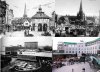
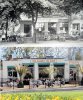
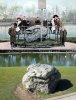
I suppose there is no better place to start than the Bullring through the years, this is something that I hurriedly knocked up some years back to illustrate something on another site. I think it is pretty amateurish, but obviously the council didn't think so because they nicked it for one of their webpages. The second photo shows the Bull that adorned the façade over the Queensway.
 

Attachments

  • Bullring through the years.JPG
    Bullring through the years.JPG
    200.2 KB · Views: 749
  • A Pair of Bulls with a 50 year Age Gap.jpg
    A Pair of Bulls with a 50 year Age Gap.jpg
    118.1 KB · Views: 625
Phil that is really great - thanks.

Sent from my LG-D802 using Tapatalk
 
Bernard


Glad that you like them, here are a couple more, I think All of us who have ever visited Cannon Hill park will have no difficulty in placing these two. For thos who have never had the pleasure, the one photo is the tea rooms on the main drive and the other is of the rock that was deposited by a once glacier that passed through Birmingham on its way from the Arenig mountains in Wales some 18000 years ago. I understand that it was removed from the area of the lake when it was being excavated in the 19th century.
 

Attachments

  • Cannon Hill Park Tea Rooms .jpg
    Cannon Hill Park Tea Rooms .jpg
    260.9 KB · Views: 421
  • Glacial Boulder Cannon Hill Park .jpg
    Glacial Boulder Cannon Hill Park .jpg
    276.5 KB · Views: 419
Top right is my favourit in the bull ring pictures, that's how I like to remember it. back in the 40's & 50's

Nick
 
A little bit of self indulgence here, 5 scenes from Balsall Heath in the 60's and what they look like today. We have Mary Street, Knutsford Street, Edward Road, Cheddar Road and Cox Street West. If you are not sure which is which just run your mouse over the photo.
 

Attachments

  • s and Now.jpg
    s and Now.jpg
    80.4 KB · Views: 427
  • s and Today.jpg
    s and Today.jpg
    78.2 KB · Views: 432
  • Balsall Heath Cheddar Rd.jpg
    Balsall Heath Cheddar Rd.jpg
    121.8 KB · Views: 438
  • s ans 2008.jpg
    s ans 2008.jpg
    68.6 KB · Views: 416
  • Balsall Heath Knutsford St 1964 and Today.jpg
    Balsall Heath Knutsford St 1964 and Today.jpg
    92.8 KB · Views: 406
Lovely photos Phil. I remember Cheddar Road - wasn't that where the naughty girls plied their trade?
 
Charlie

Yes that's right, but I believe that was in the 70's in the 60's they plied their trade in the many coffee houses that were scattered around Balsall Heath.
 
I am sure I remember that "boulder"#3, I think my dad said it was a meteorite ?, was it there in the 50's does anyone know, and is it there now?, if so, does anyone know what it is please?. Paul
 
Paul as I said in my post, "the rock that was deposited by a once glacier that passed through Birmingham on its way from the Arenig mountains in Wales some 18000 years ago. I understand that it was removed from the area of the lake when it was being excavated in the 19th century. "

As kids we always thought it was a meteor that when it hit formed the a crater that was turned into the lake, it is still there today and the later photo was taken by myself on my last visit to the park.
 
If you have any photos of a similar nature or some of those that were posted previously then please join in.
Taking up your invitation Phil, the old forum photo shown below of Arden Rd Acocks Green c1915 has always intrigued me. Was there something special about that tree for them to leave it in the middle of the road ? The second photo dated 2010 shows the same patch with a new tree, and a flyover photo today shows the patch still there in front of the house with the solar panels on the roof.
In 1915
Arden_Rd_Acocks_Green_1905.jpg


In 2010
Aco_Arden_Road_2010.jpg


Flyover now
Helicopter.jpg

The upper two pics were originally here.
 
How about Alexander road and varna road houses they was huge Victorian houses
How far back in years does these roads back to the red light days possible 1800 s maybe even further
They had huge bay windows was well and very long gardens my ancestors NAD a huge house around the backs there in the 1800 s
They used to make diarys for a business when I say my ancensters I really mean my mothers relatives
They was the poorer side of the family of jelfs mom said they ended up in the work house
It was a big house which was along from Mary street its the old pub on pershore red end which as been empty for years and is in blue across from belgrave police station my first job after leaving school wasaslaters mate and wedone roof repairs on these RDS Alexander and varna and princess rd
Best wishes astonian,,,,,','
 
I think the only thing to have changed in the last hundred years about Arden Rd except for the approach from Stockfield Rd is the name from Quality Lane. I was told at one time that the Oak tree in the centre marked near enough the centre of The Forest of Arden, but it's most likely been left without interference for all these years because of it's great age. It was old when the houses around it were first built. I know they severely cut it back a few years ago and just left the bare trunk, but it has recovered and looks quite well now even if it is an odd shape.
 
Astonian

I've just made this up for you, Varna Rd as it used to be and what they replaced it with. It seemed a little extreme to demolish perfectly good houses even if they were a little on the large size (but they are screaming out for them now) to my mind they did this to rid the area of the working girls and the bad name the area had. As I say a little in the extreme.
 

Attachments

  • Varna Rd.jpg
    Varna Rd.jpg
    95.6 KB · Views: 316
Thank you Jenny and Phil for your reply's, I have re read phil's original reply, and apologise for any misunderstanding, to think looking at that old rock I stood upon it holding dads hand, and wondered about it at age 5 years, around 1952, but I suspect earlier, that's why I love this forum, with its ability to return old duffers like me to a very happy time, thanks all, getting old now and don't always compute correctly. Paul
 
Lets take a look at some of the old pubs and what replaced them or how they look now.

We have the Dog and Partridge at the junction of what used to be Windsor Street and Ashted Row, which though it held out for longer than some it is now closed. Then we have just down the road on the junction of Revsby Walk 7 Vauxhall Rd built in the mid 60's has since been demolished and replaced by a community centre.

Then we have the Gospel Oak at the end of Gospel Lane in Acocks Green, that is now a Co-op supermarket. Also there is the Atlas at the junction of Garrison Lane & Cattel Road now the site of a piece of modern art know now I believe as "Old Blue Nose".

I have loads more pubs to post at a later time, please run your mouse pointer across the thumbnail image if you are not sure of the name of the pub.
 

Attachments

  • Dog & Partridge Ashted Row.JPG
    Dog & Partridge Ashted Row.JPG
    87.7 KB · Views: 288
  • s and Now.jpg
    s and Now.jpg
    64.1 KB · Views: 274
  • Gospel Oak..jpg
    Gospel Oak..jpg
    77.5 KB · Views: 298
  • Jct Garrison Lane & Cattell Rd c1960 and Today.jpg
    Jct Garrison Lane & Cattell Rd c1960 and Today.jpg
    63.2 KB · Views: 307
What about a quick look around the City, Broad Street, Dale End, Digbeth, Colmore Row, & New Street. Some have changed beyond all recognition, whilst others can just about be recalled.
 

Attachments

  • Broad Street.JPG
    Broad Street.JPG
    77.2 KB · Views: 387
  • City Colemore Row.jpg
    City Colemore Row.jpg
    82 KB · Views: 377
  • Dale End 1958  and Today From The Other End.jpg
    Dale End 1958 and Today From The Other End.jpg
    88.2 KB · Views: 393
  • s and the Manzil Restaurant Today.jpg
    s and the Manzil Restaurant Today.jpg
    123.7 KB · Views: 392
  • New Street 1953 and Now.jpg
    New Street 1953 and Now.jpg
    135.5 KB · Views: 395
Here's habit of info Phil from the golden years
Broad street , city,
That part of dale end between cards lane and bull street and lower priory was called originally. Called broad street,
The name dropping out of use by. Bradfords map. Of 1750.
At that date the moderen broad street was merely a country path which led from Bewdley. Street, now Victoria square
And swinford. Street. The top end of new street,, to five ways and hence. To Stourbridge and Bradley, by the 1780 the path. In that locality
Had been widened. Because of the home. At easy hill. Of the celebrated printer. John. Baskerville ,,,,,,,see easy row,,,,,,
The rest of the route was broadened. Soon after ,, this was because of the emergence of the Islington. Estate. On. Land owned by
Saint martins church between Islington row. And the top end of broad street ,,or as it termed until 1874 ,, Islington,
The development. Of this glebe land was allowed by an act of parliament passed. In. 1773 and within fifteen years building had begun
,,,,,,!,see glebe farm,,,,,,,,,, amongst the streets which were laid were the well known named street. Saint martins street
And the equally religious sounding Bishopsgate street, in the nineteenth century the short glebe street ,,,,,,,originally handover street
Was cut across the other side of broad street,l
It recalled the land ownership of. Saint martin,s and was cleared in the 1930,.s after its houses were declared as. Slums ,
Best wishes astonian,,,,,,,,,,,
 
Phil,

The biggest act of sacrilege from my personal point of view was Dale End - a lovely old street and now just a mass of ugly concrete.

Referring to the railings around the boulder (#3), I think they must have gone "to help the war effort" during WW2 as did many of our old railings. As a child I remember watching workmen remove the railings around Sparkhill Park with oxy-acetylene. It was a pretty crude job, just leaving the stubs projecting from the low walls.

Maurice
 
Thanks for posting Phil, it is so evocative for people like me who no longer live or visit the city much, and I believe I have said this before somewhere but it looked so big and stately when I was young to today.Thanks for all that information Alan it adds to the interest. Paul
 
Maurice

I wasn't born until 1947, and I can remember the rock at Cannon Hill Park with at least part of a railing enclosing it, because I can remember climbing on it as a child.
 
Hi Phil,

That shoots that idea down then! :)

I don't think the Sparkhill railings disappeared until at least 1943, maybe 1944 - I'm 10 years older than you, by the way. Cannon Hill I didn't go to very often as it meant a bus journey and I still can't remember the boulder!

Maurice
 
How about Alexander road and varna road houses they was huge Victorian houses
How far back in years does these roads back to the red light days possible 1800 s maybe even further
They had huge bay windows was well and very long gardens my ancestors NAD a huge house around the backs there in the 1800 s
They used to make diarys for a business when I say my ancensters I really mean my mothers relatives
They was the poorer side of the family of jelfs mom said they ended up in the work house
It was a big house which was along from Mary street its the old pub on pershore red end which as been empty for years and is in blue across from belgrave police station my first job after leaving school wasaslaters mate and wedone roof repairs on these RDS Alexander and varna and princess rd
Best wishes astonian,,,,,','

As far as I can remember, Alexandra/Varna/Princess Roads were part of the old Calthorpe Estate and weren't built on until the end of the Victorian era when Calthorpe gave (the rest of?) Calthorpe Park to the city. I'm not sure if they were part of the Park before then. The houses were unusually large. Some were four storeys. I think they started as family homes with servants but soon they started taking in lodgers and by the 1960s and 70s they were pretty much all bedsits. I remember working a charity pools round at the end of the 60s and having to collect from some of them. Mostly, I remember the smell.
The city tore them down in the late 70s or 80s. I'm not sure how much of them were used by prostitutes or actually working brothels but that was pretty much the end of Balsall Heath Road as a red light district.
I'm not sure what the bit about a house on Mary Street at the Pershore Road end by Belgrave Police Station means. It seems to be about two or three different places.
 
Hi warm
You are quite correct regarding calthorpes estate calthorpes are still around today they are at. The junction of Highfield road. And. Hagley
Road and oppersite the plough and harrow hotel and plough and harrow road
Calthorpes owns most of that side of the city in question of the red light roads yes they owned the lands at one point
But sold the building to the city because of the nature of the remnants whom was buying them and letting front rooms to the pro,s
Every one of them or should I say every other house was one there in those big huge bay windows either sitting there on a chair or standing
Half dressed beckoning to customers this was early fortys and through to the mid fifths it was rife
If you walked along belgrave road at that period in time you would see hundreds of males walking up and down those roads
Both sides of the roads in each and every one indeed the owners in the fortys and fifths was charging ladies of the night five pounds
Per night to rent and do business these was very natorrious lady's with there pimps in the back room for any dodgy customers
To sort them out and protect there women it would have made you laugh if you waited to see the police car or the two coppers strolling up any of these red
Because the guys could not get into there cars quick enough and almost whatching the crowds coming out of afoot ball match
All head lights on bumpeper to bumper by the period of what you said is when the city was getting a bad name and there name
The calthorpes was getting the name within the quarters of the city
Sold they compulry claimed them and demoed them and sold the land to build another comunitty estate of private sectors
As the generations of calthorpe died and passed over the calthorpe estates still exist today they owned the lands of that south side of Birmingham
Along with what was cadburys family calthorpe owned kept the hotels on that side of the city like the bristol court hotel and the beechwood hotel
And those around the area just like cadburys years ago if you bought one on the cadbury estate you have to have permission to paint your
Front door of your house a different colour it as the same ASD the bristol court hotel in the seventys
The front balcony was decaying fast and falling down they could not use just any old materiasls to patch it up
They had Togo to calthorpes for permission and used certain materials before repairing them
The hotel was crumbling. Very rapid inside and out the land all around was owned by calthorpes they pay a big part in brum even today
They own thousands of building and the lands and especially Hagley. Road. Astonian,,,,,,,
 
Lets take a look around the suburbs and see how much they have changed, in these photos we have Ladypool Rd, Balsall Heath, Monument Rd. Ladywood, Lincoln Rd, Acocks Green, and Barrack St & Great Francis St Nechells.
 

Attachments

  • Ladypool Rd old & new.JPG
    Ladypool Rd old & new.JPG
    137.8 KB · Views: 209
  • monument rd (2).JPG
    monument rd (2).JPG
    143.9 KB · Views: 221
  • Lincoln Rd 19th & 21 Century.jpg
    Lincoln Rd 19th & 21 Century.jpg
    69 KB · Views: 199
  • Nechells St James Barrack St c1930 and 2008.jpg
    Nechells St James Barrack St c1930 and 2008.jpg
    77.6 KB · Views: 192
  • Nechells Great Francis St C1930 and c2007.jpg
    Nechells Great Francis St C1930 and c2007.jpg
    46 KB · Views: 202
Still looking around the suburbs, it's good to see that not quite everything has changed completely.
 

Attachments

  • Fox Hollies - Olton Boulavard.JPG
    Fox Hollies - Olton Boulavard.JPG
    94.5 KB · Views: 184
  • Chamberlain Clock+.JPG
    Chamberlain Clock+.JPG
    184.7 KB · Views: 180
  • Hall Gree Green Lane.jpg
    Hall Gree Green Lane.jpg
    129.4 KB · Views: 184
  • Blakesley Hall Yardley.jpg
    Blakesley Hall Yardley.jpg
    84.9 KB · Views: 172
  • Hansworth Council House.jpg
    Hansworth Council House.jpg
    81.5 KB · Views: 172
Excellent comparisons, Phil. Then & Now pics are generally very difficult, but some of these have come up well. Many thanks for the postings.

Maurice
 
Back
Top