-
Welcome to this forum . We are a worldwide group with a common interest in Birmingham and its history. While here, please follow a few simple rules. We ask that you respect other members, thank those who have helped you and please keep your contributions on-topic with the thread.
We do hope you enjoy your visit. BHF Admin Team
You are using an out of date browser. It may not display this or other websites correctly.
You should upgrade or use an alternative browser.
You should upgrade or use an alternative browser.
The Roebuck - William Street, Ladywood
- Thread starter www.midlandspubs.co.uk
- Start date
www.midlandspubs.co.uk
Pub Historian
Oh, sorry ... Ladywood, on the corner of St. Martin's Street.which william st would that be kieron..nice photo
lyn
Williamstreeter
master brummie
I remember it very well I was too young to use it though
Sorry I don’t, but, I’m doing work on this street at the moment and have some background. I bet my ancestors used this pub. I had relatives at 73,74,80 11, and some back of’s, from late 19th C. To 1950’s. The Jessops, 73 ,74, seem to have run a “muffin making “ enterprise out of old wash houses “up the yard”. The supplied “kunzles” among others I believe. I’m trying to get a handle on location of street numbers. If as I think the Roebuck was 108, I think most of my addresses lie nr. the junction w. Tennant st. But can’t work out where 11 might be. Hope info is of interest. Any things to add welcomed.
Geoff
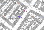
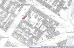
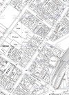
It is not very surprising that you were having difficulty with no.11. In the early 1900s a number of t,he courts were "opened up" to the roads by demolition of houses , so that they were accessed openly and not through a passage. No 11 was in the front of court 5 and was one of those demolished to open out the court. This can be seen on the c1950 map, where nos 10 & 12 are marked. On the c1889 map below I have marked no 11 in red. Hav similarly marked 73,74 and 80 on the map showing that part of william St


It is not very surprising that you were having difficulty with no.11. In the early 1900s a number of t,he courts were "opened up" to the roads by demolition of houses , so that they were accessed openly and not through a passage. No 11 was in the front of court 5 and was one of those demolished to open out the court. This can be seen on the c1950 map, where nos 10 & 12 are marked. On the c1889 map below I have marked no 11 in red. Hav similarly marked 73,74 and 80 on the map showing that part of william St


Mike, Very grateful for your reply. As a map nerd I'm fascinated by the detail you have here and inadvertently you have given me detail of Court 5 Holiday St. which was the principal centre of my family from The late 30's to the 60s . However,
please accept my apologies for misdirecting you, I see The Roebuck as St. Martins St. and that was the earlier centre of much of my family tree in the houses numbered.
please accept my apologies for misdirecting you, I see The Roebuck as St. Martins St. and that was the earlier centre of much of my family tree in the houses numbered.
Williamstreeter
master brummie
I lived at 74 William St 1955-1969Sorry I don’t, but, I’m doing work on this street at the moment and have some background. I bet my ancestors used this pub. I had relatives at 73,74,80 11, and some back of’s, from late 19th C. To 1950’s. The Jessops, 73 ,74, seem to have run a “muffin making “ enterprise out of old wash houses “up the yard”. The supplied “kunzles” among others I believe. I’m trying to get a handle on location of street numbers. If as I think the Roebuck was 108, I think most of my addresses lie nr. the junction w. Tennant st. But can’t work out where 11 might be. Hope info is of interest. Any things to add welcomed.
Williamstreeter
master brummie
Mike thanks for the plans , can I draw your attention to the fact that in plan1 of William St between 1955-1969 , No 73 didn't exist billboards were there between these years . 74 was the first house in William St from the Granville St endGeoff
It is not very surprising that you were having difficulty with no.11. In the early 1900s a number of t,he courts were "opened up" to the roads by demolition of houses , so that they were accessed openly and not through a passage. No 11 was in the front of court 5 and was one of those demolished to open out the court. This can be seen on the c1950 map, where nos 10 & 12 are marked. On the c1889 map below I have marked no 11 in red. Hav similarly marked 73,74 and 80 on the map showing that part of william St
View attachment 153160View attachment 153161View attachment 153162
Last edited:
Williamstreeter
master brummie
Mike what used to be No 73 was merged in to the building on the corner when the house was knocked down which we used to call the woodyard . They dabbled in cars and anything else , apart from the covered over area in there for the cars , the rest of the yard was strewn with old planks of wood .Thank you William for pointing that out. The map concerned is labelled (by me) as circa 1950. In fact that is the publication date and the survey is likely to around 1948. Presumably the building was demolished between then and 1955.
Hi, I've caused some confusion here in that I saw the Roebuck as a St Martins St. Pub and was referring to house numbers in that Street. However I've had Relatives who lived at 100 and 119 William St .in the 19th C. My Grandparents who lived in Holliday St. seem to have run the "White Horse" (about 101) for a while during WW2 . I have a photograph of them doing it but I don't think they held the tenancy.I lived at 74 William St 1955-1969
Nessie1952
New Member
This was on the corner of William Street opposite Tonks shop. I remedy Granpa drinking in there in 1962 and before then. They lived in a yard opposite. Happy memories of people that looked after one another.which william st would that be keiron..nice photo
lyn


