• Welcome to this forum . We are a worldwide group with a common interest in Birmingham and its history. While here, please follow a few simple rules. We ask that you respect other members, thank those who have helped you and please keep your contributions on-topic with the thread.

    We do hope you enjoy your visit. BHF Admin Team
  • HI folks the server that hosts the site completely died including the Hdd's and backups.
    Luckily i create an offsite backup once a week! this has now been restored so we have lost a few days posts.
    im still fixing things at the moment so bear with me and im still working on all images 90% are fine the others im working on now
    we are now using a backup solution

Temple Row

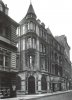
The replacement building on the corner is currently under scaffolding and is between the Great Western Arcade and Colmore Gate. Current retailers on the ground floor include Six/Eight Kafe and Forbidden Planet (both have basement levels). A-Plan Insurance is at the corner. Not sure how long the refurbishment of the building will take though.
 
The 1950 Kellys shows nos 2-8 Colmore Row as Boots, then Great Western Archade, then Karmomah. I reckon that this picture shows that all that section (at least of the Great Western Arcade had then been demolished prior to rebuilding
 
I think boots always had the position on the corner of Bull Street and after the bombing the must have purchased or leased the vacant land and built the single storey extension as a temporary structure. As Mike says Boot stretched from No's 2 to 8 Colmore Row reaching The Great Western Arcade. Barnby's Toy Store would have been at N0 5 in the arcade in the mid 50's but in between at numbers 3 & 4 was Alyson (B-ham) Ltd Drapers.

Another photo of the Colmore Row entrance in 1945 before the temporary buildings. At this time I have no doubt that the Toy Store would have been the last shop on that side of the arcade until the temporary buildings were erected. City Colmore Row - Steelhouse Lane 1945.JPG
 
By 1960 the coffee bar(Kardomah) was referred to as the goldfish bowl and the toy shop(Barnby's) was on corner on the other side of the arcade. Boots was on the corner of Bull St.
Screenshot (75).png
 
Last edited:
Is that what is now the corner of Colmore Row and Bull Street, as part of Colmore Gate?

The view from December 2015.

 
Is that what is now the corner of Colmore Row and Bull Street, as part of Colmore Gate?


]
Not familiar with modern view. Boot's was on the corner of Bull Street and Colmore Row. Bull St to the left, Colmore Row to the right
 
Last edited:
Getting back to Temple Row, in early 1960's occasionally I used to drink in the Clarendon which was on the corner with Temple Street.
 
Spotted one of these covers on Temple Row. Corporation of Birmingham (others are elsewhere around the city centre)

 
Viv

I believe the H stands for hydrant and the 4.0 stands for the size of coupling, though I'm not a hundred per cent sure. I'll ask my son later he recently retired after doing 30 years in the fire brigade.
 
Right thanks Phil. (Toyed with the idea that it was H2O and they'd forgotten to include the '2' !)Viv.
 
The 'H' does in fact refer to a hydrant - usually for fire department use but can be used, with permission, for municipal purposes. The figure 4 represents the diameter of the main and the 0 the distance. Obviousy the metal cover plate is zero feet. There would be very near, on a wall, post or some other permanent fixture. a metal plate with yellow background and having black details which would be an large H with the diameter of the main above the H cross bar and the distance of the plate from the actual hydrant given below the cross bar. The example shows the more recent metric dimensions.

.
hydrant_testing.jpg
 
Close up details of the sculptures above the entrance to the Great Western Arcade. I think they were restored last year.

Allegories of Science and Art


A huge puzzle to me...hoping someone can help? This is an extract from a piece I'm preparing of the history of the Eye Hospitals in Brum....."

Joseph Hodgson, a British eye surgeon, started his campaign to open an eye hospital in Birmingham in October 1823. Six months later, in April 1824, The Infirmary for the Cure of Diseases of the Eye was opened at Cannon Street, Birmingham.


In 1853 after 30 years at Cannon Street, the increase in work at the infirmary meant a larger hospital was needed. To accommodate for this need, a house was bought in Steelhouse Lane and converted into a 15-bed hospital known as the Birmingham and Midland Eye Institution.


By 1861 the Steelhouse Lane property also became too small to accommodate the increasing number of patients the hospital was treating. The Steelhouse Lane property was offered to the Birmingham and Midland Free Hospital for Sick Children and the Birmingham and Midland Eye Institution moved out to a property in Temple Row in 1862, which provided room for 50-beds.


On the move to Temple Row the Institution changed its name again to the Birmingham and Midland Eye Hospital.

The new Temple Row property carried a public house licence; the hospital governors renovated the public house, letting it out to a tenant. The hospital continued to own this inn for the next 20 years.


Meetings were held in February 1880 as the hospital continued to grow to discuss remodeling the hospital on Temple Row to accommodate more patients. Architects involved in the plans for the remodel thought that in order to build a hospital large enough to accommodate its growth in patient numbers the building would have to be too tall to comply to the existing rights of light in place at the time.


By December 1881 these concerns had been resolved and the design for the building was agreed. The new building would include a waiting room to accommodate 200 people, two main wards, two contagious wards, an operating theatre, nurse’s rooms and a library.

So....the Temple Row building seems to have been a pub/eye infirmary?!! Never ever heard of this before.....any ideas where this might have been? Is it on any old maps mike?
 
The 1888 Kellys lists the Birm & Midland Eye hospital as being in Church St., and the c1889 map shows the "Eye hospital" as being between Barwick st & Edmund St. It is still shown there on the c1905 map, and in the 1904 Kellys. The 1905 maps did not always show all the changes over earlier editions, but i would have thought that something as large as this would have been recorded
 
However, to add to that, the 1868 Kellys does list the Birm & Midland Eye Hospital as being at 26 Temple Row. The street was renumbered after, but it is the same number as the Royal hotel, which must be your pub. By the 1884 directory it is still there with the Royal, and its position can then be identified as being next to and to the west of The Northwestern Arcade. but by the 1888 edition it has disappeared, and number 26 is not listed. So it moved to Church St the late 1880s. the c1889 map below shows what I think was its approximate position.

map c 1889 showing earlier approx. positionof eye hospital in Temple Row.jpg
 
The 1888 Kellys lists the Birm & Midland Eye hospital as being in Church St., and the c1889 map shows the "Eye hospital" as being between Barwick st & Edmund St. It is still shown there on the c1905 map, and in the 1904 Kellys. The 1905 maps did not always show all the changes over earlier editions, but i would have thought that something as large as this would have been recorded

You are a scholar and a gent Mike...many thanks....
 
Mike & Dennis

I can't speak for the eye hospital, but the Royal Hotel (Old Royal) was as Mike says on the corner of Temple Row and Bradford Passage. The hotel was certainly big enough to house the Eye Hospital and some years later when it had to make way for the new Rackham's store it also moved to Church St when they moved into the Red Lion and renamed it The Old Royal.
 

Attachments

  • City Temple Row Ye Olde Royal.jpg
    City Temple Row Ye Olde Royal.jpg
    98.1 KB · Views: 47
  • City Temple Row The Royal Hotel.JPG
    City Temple Row The Royal Hotel.JPG
    115 KB · Views: 46
Screenshot (116).png
Plaque on the building in Church St confirms the above dates. I can remember being a patient there in 1957ish
 
Two post-WW2 images looking up Temple Row towards St Phillip's churchyard.much WW2 bomb damage. But Rackhams original store seems unscathed. This illustrates what an extensive shop Rackhams had become with its premises covering a large section of Temple Row wrapping around the corner of Bull Street and onto Corporation Street. The new Rackhams Dept Store (rear entrance) would be further up Temple Row.

The old original NW Arcade must have been demolished (left, visible above the parked van) when the new Rackhams was built. Interesting that a new arcade was made to replace the old NW Arcade. For once developers must have noted this useful short-cut from Corporation Street through to Temple Row and the Great Western Arcade on the other side of Temple Row. Viv.

image.jpeg image.jpeg
 
In 1956 my wife to be worked in the display(window dressing)department in this building of Rackhams.
 
Last edited:
The developers may have had an obligation to provide shop units for smaller shops displaced by the rebuild of Rackhams in which case reinstating the NW Arcade would have been an ideal place. I remember the arcade being T shaped with a branch going off to Bull Street but that has disappeared.
 
David
Would the other branch have led into Grays. As I remember it (in late 1960s) there was an entrance at about the middle of the arcade,
 
That's right devonjim. Last time I went through the arcade I was trying to place it - it had curved windows and was quite unobtrusive from the store. The arm of the NW Arcade came out below Temple Row and was opposite the side entrance of Rackhams. I'd forgotten about it until now. When did that disappear?
 
Back
Top