-
Welcome to this forum . We are a worldwide group with a common interest in Birmingham and its history. While here, please follow a few simple rules. We ask that you respect other members, thank those who have helped you and please keep your contributions on-topic with the thread.
We do hope you enjoy your visit. BHF Admin Team -
HI folks the server that hosts the site completely died including the Hdd's and backups.
Luckily i create an offsite backup once a week! this has now been restored so we have lost a few days posts.
im still fixing things at the moment so bear with me and im still working on all images 90% are fine the others im working on now
we are now using a backup solution
You are using an out of date browser. It may not display this or other websites correctly.
You should upgrade or use an alternative browser.
You should upgrade or use an alternative browser.
Tame Valley Canal
- Thread starter mikejee
- Start date

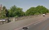
 This is a very surprising (and lovely) view of the Tame Valley Canal as it passes under the Walsall Road. I have a question. Why are there passing points (?) on the bridge ie those indents along its wall? I was always under the impression that these were to allow pedestrians to safely pass each other and to avoid stepping out into the traffic. I think it's perhaps normally where the road and pavements are narrow. But the bridge wall on both sides of the Walsall Road are very far apart. Viv.
Attachments
ellbrown
ell brown on Flickr
"Tame Valley Canal".
https://en.wikipedia.org/wiki/Tame_Valley_Canal
https://en.wikipedia.org/wiki/Tame_Valley_Canal
Think it was probably 1959 when I remember when the canal was empty at Tower Hill. The Lock by the Cottage was covered in dead fish, Roach I think, which we had spent a couple of years trying to catch but all we ended up with was gudgeon and stone loach.As children in the Perry Beeches area, the canal was our playground ... we used to call it the 'cut'.
In the 1960s at the Hamstead GKN factory we had long lunch hours and during one cold winter on several days we went along the towpath from the Walsall Rd bridge and skated on the Basin marked on the map below.
So I was still playing on the canal in my twenties !
View attachment 110712
oldMohawk
gone but not forgotten
I notice that the are only two indentations per side and they match the stone work on the canal side of the bridge, but I can't think why.View attachment 110714 This is a very surprising (and lovely) view of the Tame Valley Canal as it passes under the Walsall Road. I have a question. Why are there passing points (?) on the bridge ie those indents along its wall? I was always under the impression that these were to allow pedestrians to safely pass each other and to avoid stepping out into the traffic. I think it's perhaps normally where the road and pavements are narrow. But the bridge wall on both sides of the Walsall Road are very far apart. Viv.

Pedrocut
Master Barmmie
Tower Hill also supplied stone for the canal contractors
In May of 1845 the Tower Hill Quarry advertised saying that most of the bridges on the new Tame Valley Canal are built of stone from the quarry. So Zoom in on the Walsall Road bridge!
This photo shows exactly where we used to fish, when it rained we moved under the bridge.I notice that the are only two indentations per side and they match the stone work on the canal side of the bridge, but I can't think why.
View attachment 110716
DavidGrain
master brummie
I remember the old road from West Bromwich to Walsall used to go down a steep hill then a sharp left turn under the Tame Valley Canal before rising the other side of the valley. I used to ride this way on my bike. The modern road goes over the canal.
Lady Penelope
master brummie
My Dad was born in Bridge Road, now under Spaghetti. It was a real community then and the houses were solidly built. They couldn't have been much more than 50 years old when they were demolished. Another Birmingham sacrifice to the car. Dad was born in 1913 and used to play on the canal (as I expect most boys would've done then). He fell in and went down between two boats (barges?). He always said he was very lucky as he went straight down and came straight back up again as, if he'd hit the bottom of the boat, he would've been a gonner. Don't expect it stopped him playing by the canal though! There was an outdoor in Leamington Road, just at the end of Bridge Road, I can still remember the smell and see the copper funnel used to transfer the beer into your own bottles. I also seem to remember big wooden doors at the side of the outdoor which led to the canal.
Lady Penelope
master brummie
Hi Viv, your post #32 made me wonder if the indentations in the bridge were merely following the design of earlier bridges in the area. When the Bridge Trust was set up (1600's? - I think by Nicholas Hodgetts but willing to be corrected) all the bridges were narrow and had them. The one at Perry Barr, opposite Wickes, is still there.
Handsworth Grammar school badge appears to show the same shapes and the funding for this came from the Bridge Trust didn't it?
Handsworth Grammar school badge appears to show the same shapes and the funding for this came from the Bridge Trust didn't it?
Very plausible Lady P. As you say, the Walsall Road Bridge and Aldridge Road Bridge both seem to copy the old Zig Zag (Perry Pont) Bridge in style. The old thread link below suggests that the old Zig Zag Bridge (which is parallel with the Aldridge Road bridge) had rights to draw off water and to fish from there.
Maybe the indentations along the original Zig Zag bridge were designed originally as passing places (once a busy bridge used by carts) but later used for these other purposes. It's quite possible that the later Aldrdge Road and Walsall Road bridges incorporated the original Zig Zag features into their design with no specific purpose other than decorative.
https://birminghamhistory.co.uk/forum/index.php?threads/zig-zag-bridges-of-brum.9557/
Viv.
DavidGrain
master brummie
Looking at the satellite view, I would say that this work was to strengthen the abutments for the new bridge bearing in mind that the road is on a made up embankment both sides of the bridge.

devonjim
master brummie
Always thought of these as "pack horse bridges" and imagined that the recesses enabled horses with panniers to pass each other in much the same way as passing places on narrow roads allow cars to pass. I always thought that the recesses on the bridge in Walsall Rd were design features, so mainly decorative.
Last edited:

oldMohawk
gone but not forgotten
I would agree that the recesses appear to be decorative design features. The Tame Valley Canal bridge on the Aldridge Road, about a quarter of a mile north of the 'zig-zag' River Tame bridge, never had recesses even when the road was relatively narrow up to the end of the 1950s. What would be interesting to see is an early photo of the A34 Walsall Road bridge but I cannot find one.Always thought of these as "pack horse bridges" and imagined that the recesses enabled horses with panniers to pass each other in much the same way as passing places on narrow roads allow cars to pass. I always thought that the recesses on the bridge in Walsall Rd were design features, so mainly decorative.
Before mechanical dredgers, spoon dredging the canal (before Spaghetti Junction was built on this spot). Image from early 1900s. Viv.


Radiorails
master brummie
It does suggest here that some canal transportation to Hardy Spicer did take place from the Witton firm of Forgings and Presswork Ltd. (a subsidiary of HS since 1938) as a result of the Suez Crisis. The Suez crisis was in 1956 - I know I was in the RAF at the time and great staff movements were organized and curtailed pretty quickly due to pressure by the USA and much to the annoyance of France. It was the first occasion I was issued with petrol coupons.
I wonder how long this canal shipping lasted? Did it last until the canals closure whilst Spaghetti Junction was constructed and a new canal line built?
I wonder how long this canal shipping lasted? Did it last until the canals closure whilst Spaghetti Junction was constructed and a new canal line built?


Used to walk over Tower Hill bridge on my way to and from Beeches road School, seem to remember there being bollards to prevent vehicle access.There has been discussion about the bridge at Tower Hill. Notice issued October 1943 refers to it being known as Freeth Bridge.
View attachment 141157