• Welcome to this forum . We are a worldwide group with a common interest in Birmingham and its history. While here, please follow a few simple rules. We ask that you respect other members, thank those who have helped you and please keep your contributions on-topic with the thread.

    We do hope you enjoy your visit. BHF Admin Team
  • HI folks the server that hosts the site completely died including the Hdd's and backups.
    Luckily i create an offsite backup once a week! this has now been restored so we have lost a few days posts.
    im still fixing things at the moment so bear with me and im still working on all images 90% are fine the others im working on now
    we are now using a backup solution

Staniforth Street Old Wall

Shelagh

Shelagh
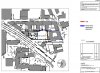
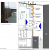
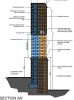
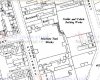
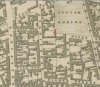
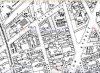
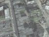
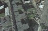
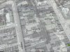
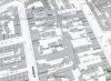
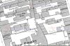
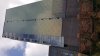
I am not sure if I am in the correct place, I haven't been on for a long while and the site has changed so much. we took our granddaughter to the Unite student flats at no 30 Staniforth st .Inside the ground there is a thick wall, obviously very old it seems to run the length of the flats and is also surrounded by many other sky scrapers, all appear to be student accomodation. Does anyone
know about this wall , or what was there before, it could even be part of a chimney. Or Listed.
Shelagh
ps what is a photo bucket ?
 
hi shelagh thanks for the photo...i have turned it round for you...i went down staniforth st a few days back in search of your wall but could see no way to get a closer look at it..is there an easy way to get in

lyn

wall.jpeg
 
hi shelagh thanks for the photo...i have turned it round for you...i went down staniforth st a few days back in search of your wall but could see no way to get a closer look at it..is there an easy way to get in

lyn

View attachment 108353

The entrance is on Staniforth street. As you come from bagot street it's on the left, opposite the council car park. It's an archway into the unite student accommodation car park. When you enter the arch, there is a path leading to the left and the wall runs alongside the path.
Shelagh
 
I think this is part of it but am not sure as the aerial shot was hard to get right. I could not find anything "listed" in the area.
Janice
 

Attachments

  • old wall.JPG
    old wall.JPG
    25.7 KB · Views: 39
  • old wall 2.JPG
    old wall 2.JPG
    28.2 KB · Views: 36
thanks for the aerial shots janice that is exactly how i saw it...shelagh so i could get to the wall via the car park then ?

lyn
 
I have looked on old maps - the wall seems to follow the line of the old buildings and a scrap yard but none seem significant. I wonder if there is a difference in height of the ground and it was left as a retaining wall of some sort. It would be interesting to see plans of the development to see if there is any indication of why the wall was left. Unless it is linked to the Penworks which is the only listed building I found in Moland Street and backing onto the area.
Janice
 
Last edited:
morning janice..when i took a look a few days back i could actually see the wall but only from the locked gates of the complex on staniforth st...the position looks about right to me.think i would need permission to get any closer to wall..but as you say...why has it been left standing

lyn
 
I tried to see if I could find out who the architects were of the flats, or see the planning application to see if it said why. Only had a quick look - planning applications only seem to be online until permission is given and wasn't successful with finding the architects.
On the description of the Pen Works (listed) it does refer to the "slope of the land" and later "the fall of the land" - that is why I wondered if it was retaining soil. No mention of anything else listed on the site.
Janice
 
ok janice thanks for trying to find anything else out about this wall:rolleyes: 
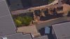
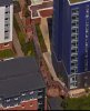
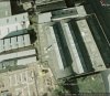
i dont have time at the min but i think when i have i may go down again and try and speak to someone..its a long shot though unless of course mike maybe able to pinpoint what building the wall belonged to

lyn
 
I think I have found out some info - just trying to save documents - it seems it is part of a listed building in Moland Street.
Janice
 
Right here goes. This application made in 2013 refers to part of the boundary wall of a building backing on to the site where the flats are. There was a lot of other bits of paperwork but I have saved the ones which help most. Namely a map, press notice and plans. Had problems uploading as they were pdf files and wouldn't open properly. Hope this works.
See what you think.
Janice
 

Attachments

  • newspaper.JPG
    newspaper.JPG
    22.4 KB · Views: 22
  • Map.JPG
    Map.JPG
    91.6 KB · Views: 21
  • plans.JPG
    plans.JPG
    58.2 KB · Views: 22
great janice...the photo that goes with the plans definately looks like our wall the snippet mentions the pen works but i would have thought the pen works was too far away to see it from staniforth st....if mike could have a look at post 21 maybe he can identify the tower block which shows the wall below it and then overlay on a map to see what building was attached to the wall before demolision but i think we are making some headway now

lyn
 
I think the tower block is called Penworks House. I suspect that the original pen works may have been linked to a building long gone or a larger building with only part of it saved but for some reason that wall remained and became part of the listing when the pen works was listed. Guesswork as it is hard to tell how far buildings stretch - on the map it does look as if the new build and the pen works sort of halve the land so it might be possible - it just seemed a huge coincidence if it wasn't our wall.
Janice
 
i agree with you janice....will ask mike to take a look at this thread and see what he can come up with..

lyn
 
Have examined the OS maps and overlaid the c1889 map (probably actually about 1884) on Google Earth. Have also examined the directories . The first thing that is apparent is that , unless the Newhall pen works took over some nearby buildings for a short time after WW2, which is very unlikely, the wall has nothing to do with the penworks, and the "Penworks House" is just a name conjured up by some planner because it sounded good and was in an are where there were a number of pen manufactories. Newhall Penworks was, as seen in the . OS map c1921 (Fig.1) a fair distance from the site. In fact the Newhall Penworks was only built in 1907 (https://historicengland.org.uk/listing/the-list/list-entry/1391127). Overlaying the large scale OS c 1889 map shows that the wall, or at least the main straight bit with the three supporting columns of brickwork are marked on the 1889 map , as can be seen in Figs 2-5 where the overlay opacity is reduced by differing amounts . Fig 6 shows the c1889 map in closer detail. The c1921 and c1937 maps (Figs.1 & 7) do not show it, though the 1937 map has a space between buildings where it would have been. The c1950 (Fig. 8) and c1970 maps show a wall, but no supporting brick pillars.

I tend to agree with the suggestion that it was just a supporting wall for earth necessary because of the slope of the land. The c1824 Pigott Smith map (Fig 9) shows it would have been possibly a border wall with the land of Josiah Robins but wonder why on earth it was preserved .
 

Attachments

  • Fig  8. map c 1950 showing wall. but not supporting brick columns.jpg
    Fig 8. map c 1950 showing wall. but not supporting brick columns.jpg
    77.3 KB · Views: 13
  • Fig. 9. map c 1824 showing about where wall would have been.jpg
    Fig. 9. map c 1824 showing about where wall would have been.jpg
    71.1 KB · Views: 14
  • Fig.1.map c 1921 moland st Newhall pen works.jpg
    Fig.1.map c 1921 moland st Newhall pen works.jpg
    125 KB · Views: 13
  • Fig.3. overlay of 1889 map of wall.jpg
    Fig.3. overlay of 1889 map of wall.jpg
    165.2 KB · Views: 12
  • Fig.2. overlay of 1889 map of wall.jpg
    Fig.2. overlay of 1889 map of wall.jpg
    213.3 KB · Views: 12
  • Fig.4. overlay of 1889 map of wall.jpg
    Fig.4. overlay of 1889 map of wall.jpg
    149.8 KB · Views: 12
  • Fig.5. overlay of 1889 map of wall.jpg
    Fig.5. overlay of 1889 map of wall.jpg
    122.9 KB · Views: 12
  • Fig.6. map c 1889 detail of poss wall.jpg
    Fig.6. map c 1889 detail of poss wall.jpg
    119.1 KB · Views: 12
  • Fig.7. map c 1937 moland st Newhall pen works.jpg
    Fig.7. map c 1937 moland st Newhall pen works.jpg
    89.4 KB · Views: 12
thanks for taking so much time over this one mike..i am still leaning towards the iron foundry but could be totally way off the mark..as i said when i have time i will try and talk to someone who may know the history of the wall and as you say...just why was it preserved..its a mystery..cheers mike

lyn
 
Thanks Mike for all your efforts. The only reason I thought it was Newhall Pen Works was because of the wording in the newspaper notice and the fact it is the only listed building in the area. However, I do agree it may only be there because of the different land levels. I have now read the one document that I didn't spot yesterday (on page 2) and that I cannot attach because of its size - 63 pages (and the significant wording is the bit I have put below). The rest does make interesting reading in part because of the detail of history.
Janice
 

Attachments

  • wall.JPG
    wall.JPG
    50.9 KB · Views: 5
Last edited:
Mike and Lyn - I should have said that I am not sure the planners know what the wall was originally built for and feel Mike's research tells us more about the origins. It just seems to be considered a boundary wall of the pen works - not sure why that means it gets listed. The bit I can't see for sure is how long this wall actually is. On the aerial photos it looks to be quite long extends away from the pen works.
Janice
 
Last edited:
Just a quick thought - need to go out so will have to check this later but I think the two sections of wall, Shelagh's and the one in the planning application, are different. I now think the planning wall runs at right angles to our wall ie it goes off our wall and towards Moland Street. It is, or was, part of the same build. I am wondering if the wall was a long one built well before the Newhall Pen Works but left to retain the soil and that parts of it have become classed as the boundary of the listed site. It also seems as if that wall continues at the back of the Staniforth buildings. What do you think? Or is it my imagination again!!
Janice
 
Right - the attached map should show what I mean. Purple line is our wall - no idea how long it is thought. Green(ish) line is the wall in the planning application.
Janice
 

Attachments

  • Scan_20160913.jpg
    Scan_20160913.jpg
    258.3 KB · Views: 14
Not sure how much help this is, but below are from google earth going back (have missed out one where resolution was poor and area covered in vegetation). It looks to me like the wall was an integral part of the wall to the old factory around 2000
 

Attachments

  • 1.1,2001.jpg
    1.1,2001.jpg
    88.2 KB · Views: 13
  • 11.1999.jpg
    11.1999.jpg
    73.9 KB · Views: 12
  • 14.4,2007.jpg
    14.4,2007.jpg
    105.9 KB · Views: 12
  • 18.10.2003.jpg
    18.10.2003.jpg
    100.9 KB · Views: 12
  • 22.5.2012.jpg
    22.5.2012.jpg
    92.6 KB · Views: 12
  • 29.9.2011.jpg
    29.9.2011.jpg
    95.9 KB · Views: 12
Yes - I agree that looks right. Still think it must have been kept to retain soil because of different levels. I found a slightly different planning application to lower it in height which referred to is as a retaining wall. So hard to tell from maps and aerial shots - hopefully someone can get for a look for real. Although this is time consuming I find it fascinating. Thanks Mike.
Janice
 
Last edited:
seems about right to me as well janice...i am very busy for the next week or so with one thing or another but when i get time i will get down there and see if i can get in to take a better look at the wall....

lyn
 
I have read several of the other planning applications connected with the wall - some of which were refused (I didn't realise one actually proposed pulling down the Newhall Pen Works, that was 2004!). I don't think the applicants really knew - one suggested the wall was built at the time of the Works in 1907 and another had maps attached showing the wall had been there prior to the Works being built. I think Mike is right - that the wall was part of an older building or buildings and was left to hold back the soil. It looks as if several smaller buildings had the wall in common and it was left when they were demolished.
Janice
 
hi folks...forgot i had to meet my sister in town today so i decided to go earlier than planned and got off the bus 2 stops before town..into lawson st and then into staniforth..managed to get into the courtyard but not before getting locked in the passage that led to it and then i got locked in it again trying to get back out onto staniforth st:rolleyes:...dont ask lol...just having a little rest and a cuppa and then i will post the photos..hope they have come out ok as i did not hang about

lyn
 
Back
Top