-
Welcome to this forum . We are a worldwide group with a common interest in Birmingham and its history. While here, please follow a few simple rules. We ask that you respect other members, thank those who have helped you and please keep your contributions on-topic with the thread.
We do hope you enjoy your visit. BHF Admin Team -
HI folks the server that hosts the site completely died including the Hdd's and backups.
Luckily i create an offsite backup once a week! this has now been restored so we have lost a few days posts.
im still fixing things at the moment so bear with me and im still working on all images 90% are fine the others im working on now
we are now using a backup solution
You are using an out of date browser. It may not display this or other websites correctly.
You should upgrade or use an alternative browser.
You should upgrade or use an alternative browser.
Staniforth Street Old Wall
- Thread starter Shelagh
- Start date


last few...have to say and i am no expert but these bricks look very old to me and look as though they have burning on them..almost like chimneys..i originally thought maybe part of the iron foundry then changed my mind but now im not sure again


Last edited:
its a strange one mike...as i said i entered opposite the safe storage building and then turned left when i got into the courtyard...if you look at the link below and slide the blue dot across we can see that the iron foundry was there and the wall kind of kinks at the back of it..we may never know for sure but at least we have some good photos of the wall now...
https://maps.nls.uk/geo/explore/#zoom=18&lat=52.4884&lon=-1.8930&layers=176&b=6
https://maps.nls.uk/geo/explore/#zoom=18&lat=52.4884&lon=-1.8930&layers=176&b=6
pjmburns
master brummie
Fantastic - it is good to know exactly where that wall goes and to see what it looks like. I think you are probably right Lyn about the Iron Foundry. I am going to have another look at one of the planning applications as I think there was a reference to the Josiah Robins Mike mentioned in #20.
Janice
Janice
Last edited by a moderator:
morning janice..could do with trying to have a look at the wall from the other side of it now...did not have time to try and do that yesterday....as far as my eye could see i could not see any reason why the wall is still there and what purpose it serves if any...unless of course it is listed....its amazing just how much history is still around that we dont know about unless its pointed out to us..as the wall is so long it cant all be connected to the iron foundry but i think it definately runs at the back of it so could just be a retaining wall i guess...the plot thickens..for those that dont know if you click on the arrow at the top right of the photos they will enlarge to full screen..later on hoping to take all the posts from post 17 on this thread and will set up a new thread called.."old wall staniforth st"....
lyn
lyn
Last edited:

pjmburns
master brummie
Morning Lyn. I wondered if the wall was so long as several buildings were built in one go - like a sort of terrace of workshops, if you see what I mean. That way people would not know where the individual buildings were once they had come down and only the joint wall was left. It could mean that the wall was part of several places including a foundry. I am not sure whether the buttresses would be inside or out. Looking at the marks on some parts they were probably inside. That plan I posted seemed to indicate a retaining wall and I saw it called that in the planning applcation I found.
Janice
Janice
pjmburns
master brummie
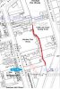
I assume the building in photo 2 in #33 was the old employment exchange. If the wall ran from opposite that entrance to the left then it is at the back of the iron foundry in Staniforth Street but also looks as if buildings fronting Moland Street could have also had it as a back wall. I know we have other maps but I am trying to get things clear in my mind - is the attached about right? Machine tool works is roughly where the Iron Foundry was.
Janice
Janice
Attachments
oldMohawk
gone but not forgotten
A 1950 view below, of the area with two buildings that can be seen on Google Earth and Apple Maps today. There appears to be a wall with possible buttresses and on the other side of the wall could be large piles of scrap or ore. The wall can be clearly seen in an aerial view on Apple Maps which shows the site cleared ready to build the tall building seen in post#3.

Image from 'britainfromabove'
Image from 'britainfromabove'
I assume the building in photo 2 in #33 was the old employment exchange. If the wall ran from opposite that entrance to the left then it is at the back of the iron foundry in Staniforth Street but also looks as if buildings fronting Moland Street could have also had it as a back wall. I know we have other maps but I am trying to get things clear in my mind - is the attached about right? Machine tool works is roughly where the Iron Foundry was.
Janice
yes janice i would say that the machine tool works is exactly where the iron foundry was and i also agree that the moland st buildings had it as a back wall thats why i want to get to take a look round moland st...
thanks phil...it does look like a pile of scrap but could also be a demolished building..
Phil
Gone, but not forgotten.
After reading this thread and looking through the photos, this is my opinion on the wall, having a little experience in the demolition game and therefore also knowing a little on how buildings are constructed. Looking at the substantial concrete foundations that can be seen under the wall this to me demonstrates the fact that the wall has always been used for the purpose of retaining what was in the other side of it and preventing landslip. Most buildings of the time this wall was built were built on little on no foundations other than what were called spread footings. The buttresses would have been built on the other side of the land the wall was built to retain.
As for the brickwork I would say it was mid Victorian the reason it looks blackened would most likely be the same as for any brickwork of that time the area was heavily industrialised and most buildings in Birmingham looked black until they were cleaned up recently. It's either that or they were overdone in the kiln when being manufactured.
As for the brickwork I would say it was mid Victorian the reason it looks blackened would most likely be the same as for any brickwork of that time the area was heavily industrialised and most buildings in Birmingham looked black until they were cleaned up recently. It's either that or they were overdone in the kiln when being manufactured.
oldMohawk
gone but not forgotten
Looking at one of Mike's maps c1889 in a Sawmill Staniforth Street post#5 and looking for buttresses I can almost imagine that these could be them in the circle. If so they were large enough to show on a map.

thanks phil i agree i can only think it was a retaining wall but as said before i cant understand why its still standing...dont really think we can go much further with this mystery unless of course someone knows something we dont but i will try to get down to moland st asap and take a look round