• Welcome to this forum . We are a worldwide group with a common interest in Birmingham and its history. While here, please follow a few simple rules. We ask that you respect other members, thank those who have helped you and please keep your contributions on-topic with the thread.

    We do hope you enjoy your visit. BHF Admin Team
  • HI folks the server that hosts the site completely died including the Hdd's and backups.
    Luckily i create an offsite backup once a week! this has now been restored so we have lost a few days posts.
    im still fixing things at the moment so bear with me and im still working on all images 90% are fine the others im working on now
    we are now using a backup solution

Staniforth Street

dennis is that the ben johnson pub bottom left of the red square...im lost lol

lyn
 
Yes Lyn. It is

thought so mike....that used to be our 2nd stop off heading into town on friday nights the first one being the turks head round the corner...building still there but no longer a pub...had some great nights in both in the early 70s

lyn
 
These photos and information were lost in the recent server crash so are restored here.
Pic 1 (also posted elsewhere on the forum) shows some very poor housing conditions. A wall plaque can be seen on a wall in the street beyond and there are suggestions that it is a war memorial and if for WW1 then the poor housing was obviously there in the early 1920s. There is nothing in this image which identifies the location but the following sequence of photos will.
Pic 1
View attachment 102836

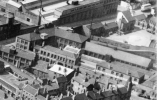
Another view of the buildings and lavatory block in Pic 2, still showing very poor conditions and the edge of the wall plaque can just be seen. The original caption with the pic source suggests it is named Bagot St Court.
Pic 2
View attachment 102837

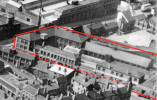
In Pic 3 below the buildings on the right have been reconditioned and the lavatory block demolished. The wall plaque can be seen and also part of an Ansells Pub. Apparently there was a project of reconditioning some slum housing in Birmingham but I have not been able to find any information about it. A close look at the memorial suggests there is a vase of flowers on it.
Pic 3
View attachment 102838

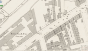
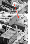
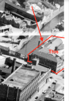
Another view of the the reconditioned buildings and more of the pub showing. Also a street name shows on the pub wall but is not clear in this jpg image. A low tower-like building with a conical roof can also be seen and looks to be part of the pub. The conical roof can be seen in an aerial photo on the 'britainfromabove ' web site.
Pic 4
View attachment 102839

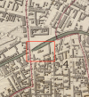
With some photo editing on the original pgn file it reads Staniforth St as shown below, so the pub is the White Hart on the corner of Staniforth St/Bagot St. I've seen this confirmed on an old map but there does not appear to be any available photo of the pub. The house on the right in the previous pics backs on to Bagot St so maybe is why the court is known as 'Bagot St Court'
Pic 5
View attachment 102840
Great old photos! Here's the location from the 1888 Ordnance Survey map. Bagot Court is in the lower middle of the map. The three-hole lav is plainly shown at the western end of the court — Coggo
 

Attachments

  • Bagot Ct.png
    Bagot Ct.png
    712.1 KB · Views: 16
thanks coggo...please remember folks we are still searching for a photo of the small arms factory as seen on coggos map...i believe it later became a bicycle factory...

lyn
 
That's right, Lyn, and thanks. When in 1894 the government small-arms repair facility moved in with the (then) new Royal Small Arms Factory Sparkbrook (on Montgomery Street), the old Bagot Street building got taken over by Osmond Cycles. Eventually (I don't know when), the Bagot location was taken over by Hallam, Sleigh & Cheston. They were there until 1983, when it was demolished to make way for a warehouse. The warehouse has since been replaced by the modern student housing that sits on the site today.

As for the Montgomery Street factory, this was sold by the government to BSA in 1906. BSA Tools was housed there for a long time, certainly into the 1950s. I don’t know when BSA Tools moved from there to Mackadown Lane.

Thanks, all — Coggo
 
hi coggo this link looks interesting although you may have already seen it.. if i have read it correctly it looks like osmond cycles took over the site at bagot st in 1894 and looking at the badges there could have been an actual tower on the site but i could be wrong...


lyn
 
Yes, I’ve wondered in the past about the Osmond logo, Lyn. Odd, isn’t it? There was certainly no tower on the site when Hallam, Sleigh & Cheston had the Bagot Street place (see 1950s aerial view). On the other hand, an old 1839 map shows, not surprisingly, a much less developed site with two L-shaped buildings and another structure in the middle. Maybe the middle building featured a tower of some sort. Just a guess, but who knows? — Coggo
 

Attachments

  • Bagot 1950s.png
    Bagot 1950s.png
    397.8 KB · Views: 12
  • Bagot 1839.png
    Bagot 1839.png
    1.2 MB · Views: 11
Yes, I’ve wondered in the past about the Osmond logo, Lyn. Odd, isn’t it? There was certainly no tower on the site when Hallam, Sleigh & Cheston had the Bagot Street place (see 1950s aerial view). On the other hand, an old 1839 map shows, not surprisingly, a much less developed site with two L-shaped buildings and another structure in the middle. Maybe the middle building featured a tower of some sort. Just a guess, but who knows? — Coggo
think i would agree that if there was a tower to some sorts it would have been long before 1950...interesting though

lyn
 
coggo from your 1839 map showing where the building was it looks to be between princip st and cliveland st with the canal close by...would this map originally posted by john i think show the building i can see a building next to the canal ..lyn


index.php - 2024-01-30T204015.897.jpg
 
Last edited:
Yep, this is it here, Lyn (see attached excerpt), on the south-east corner of the Lancaster Street bridge — Coggo
 

Attachments

  • From Princip.png
    From Princip.png
    257.7 KB · Views: 6
so coggo is it the building on the front with writing on it that i just cant make out...just need to be sure because if it is i am surprised we do not have an actual photograph of it but somewhere in my mind i know there is an old photo taken around there and i am trying to find it..i cant look in my photos of which i have thousands as i have not yet taken them from from old lappy and put them on this new one..really must get round to it

lyn
 
Not directly answering the question, but I do not think, surprisingly, that this , concerning the ordnance factory has been mentioned before on the forum

 
how interesting mike...reading the link i remember the old wall very well walked past it many times and was still there a few years ago however i cant recall seeing the sandstone block which was removed in 2010


The sandstone block shown at the top of this blog post was part of a wall that once marked the extremity of the Tower site and was removed in 2010 to the Birmingham Proof House Museum.
 
Yes, what Lyn says is correct. I believe the stone was indeed removed when the student housing went up on the site, and that the Proof House has it now. The stones were used to mark the perimeter of such establishments, one at each corner. One of the corresponding stones at the Montgomery Street rifle factory (later the BSA Tools Ltd site) is still there. It is stone No. 2 of the 8 that used to surround the Montgomery Street establishment.

As for Lyn’s question about which building is the old Bagot Street “Tower” from the aerial photos, on the two attachments I’ve outlined it in red as best I can. The writing on the Bagot Street side says “Hallam, Sleigh & Cheston”.

On another site I found a photo of the place about to be demolished in 1983. See the second-to-last attachment: you can see that the roof is off already. The photographer of this 1983 photo was looking east from the intersection of Princip and Lancaster. The very last attachment shows the same view today — Coggo
 

Attachments

  • 1  From Princip copy.png
    1 From Princip copy.png
    267.6 KB · Views: 6
  • 2 Bagot 1950s copy.png
    2 Bagot 1950s copy.png
    417 KB · Views: 7
  • 3 From Princip 1983.png
    3 From Princip 1983.png
    613.7 KB · Views: 7
  • 4 From Princip 2024.png
    4 From Princip 2024.png
    989.2 KB · Views: 7
Back
Top