hi janice yes i think we are looking towards what looks like potter st on your map..thing is i cant find a potter st in kellys..it definately looks like there is a street running across in my photo but to be honest i am now more confused than ever lol
-
Welcome to this forum . We are a worldwide group with a common interest in Birmingham and its history. While here, please follow a few simple rules. We ask that you respect other members, thank those who have helped you and please keep your contributions on-topic with the thread.
We do hope you enjoy your visit. BHF Admin Team -
HI folks the server that hosts the site completely died including the Hdd's and backups.
Luckily i create an offsite backup once a week! this has now been restored so we have lost a few days posts.
im still fixing things at the moment so bear with me and im still working on all images 90% are fine the others im working on now
we are now using a backup solution
You are using an out of date browser. It may not display this or other websites correctly.
You should upgrade or use an alternative browser.
You should upgrade or use an alternative browser.
Staniforth Street
- Thread starter Astoness
- Start date
Phil
Gone, but not forgotten.
Lyn
I think Janice is right also, its the only logical solution. In the early 1900's the editions of Kelly's start numbering at Potter Street and the first commercial premises are 16-17 D R Price on the east side and the road continues down to Bagot Street. I think that Potter Street must have disappeared under the Central Fire Station at the beginning of the thirties.
So to answer your first question the number of the house next door to D R Price must have been number 14.
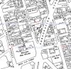
Sorry but have only just got to this thread. I did a lot of work some time ago trying to place the exact position of some buildings more to the north on the east side, and I remember this photo. Yes you are correct , the camera is pointed towards what was Potter st. The two maps below show that in the c 1937 map (probably surveyed about 1934-5) there was new buildings down the east side of the street at the bottom, and Potter st did not run across the bottom, whereas the c 1915 map (probably surveyed about 1913) had old houses with a gap in the houses at the far end, with potter st running across the bottom.
Attachments

Phil
Gone, but not forgotten.
Mike can you come up with the full name of the premises shown on Potter Street that is displayed on the Staniforth Street photo running across the end of the street. The part of the sign we can see reads Payne & Elliot but there is obviously another name before what we can see. I was nearly driven crazy last night trying to find the complete name.
Mike can you come up with the full name of the premises shown on Potter Street that is displayed on the Staniforth Street photo running across the end of the street. The part of the sign we can see reads Payne & Elliot but there is obviously another name before what we can see. I was nearly driven crazy last night trying to find the complete name.
same here phil..ive been through some earlier kellys and cant seem to find a firm in potter st with the names payne and elliot included...

Driving me mad as well.
Janice
so we are all going barmy then janice lol...i have have another go tomorrow at trying to find this firm in potter st..
Will have a look at the 1924 Kellys, which is analogue and downstairs, tomorrow. Havent found anything on the computer. The only firm I can find with Payne & Elliot in it with the word ending with N is Dawson, Payne & Elliot, who made printing equipment, but they seem to have been in Otley, though may have had an outpost.
oldMohawk
gone but not forgotten
I'm puzzled by the timing of large changes shown on the various maps in this thread and in the Potter St thread.
Looking again at the Potter St Pic 1 - Staniforth St must be on the left just pass the telegraph pole. Further on down the road at the end of the street appears to be 'Moland' St read from the map in post#30
Pic 1 below shows considerable foreshortening but I have marked a building in it which appears to be in in the 2nd pic below.
Pic 1 with a building (3 floors and pointed roof) marked.

Pic 2 with a building (3 floors and pointed roof) marked.

The building to the right of the building I have marked looks slightly different but there were lots of changes.
The building at the end of the street in Pic 2 has broken windows so maybe demolition etc was due.
An additional thought ..... Pic 1 looks much earlier than Pic 2, also the name in Pic 2 appears to be painted on so could have been easily added.
Looking again at the Potter St Pic 1 - Staniforth St must be on the left just pass the telegraph pole. Further on down the road at the end of the street appears to be 'Moland' St read from the map in post#30
Pic 1 below shows considerable foreshortening but I have marked a building in it which appears to be in in the 2nd pic below.
Pic 1 with a building (3 floors and pointed roof) marked.
Pic 2 with a building (3 floors and pointed roof) marked.
The building to the right of the building I have marked looks slightly different but there were lots of changes.
The building at the end of the street in Pic 2 has broken windows so maybe demolition etc was due.
An additional thought ..... Pic 1 looks much earlier than Pic 2, also the name in Pic 2 appears to be painted on so could have been easily added.
Last edited:
OK - I stand corrected. I have had a look for Dawson, Payne and Elliott in some phone books but no luck yet.
Janice
no need to stand corrected janice as as first i did think it was the letter H but on closer inspection i can now see its the letter N...quite a challenge finding DAWSON PAYNE AND ELLIOT in potter st....this is of course if we are right about it all...if we are wrong we can all go mad again lol
lyn
pjmburns
master brummie
Bingo - it is Dawson Payne and Elliott. Found an image on the library website. https://calmview.birmingham.gov.uk/...c=CalmView.Catalog&id=MS+2724/2/B/4508&pos=11
Janice
Janice
Now I can do what I am supposed to be doing - marking exam papers!!
Janice
until the next mytery turns up janice...must see what i can find for you...thanks again
oldMohawk
gone but not forgotten
A nice pic ....Bingo - it is Dawson Payne and Elliott. Found an image on the library website. https://calmview.birmingham.gov.uk/CalmView/Record.aspx?src=CalmView.Catalog&id=MS+2724/2/B/4508&pos=11
Janice
I wonder if G.H.Kelley & Son. Printers Engineers (in my Pic 1) were there before Dawson, Payne, & Elliot ?
Mohawk
The two pictures are of different streets, although th ebuildings you mention are very similar. The one with the Weights & measures dept is Potter St (which , if it still existed , someone would probably be campaigning to rename it Harry Potter St), and the other is Staniforth St. The Staniforth st one has 3 story buildings all the way along, whereas the Potter st has 2 story ones to the right
The two pictures are of different streets, although th ebuildings you mention are very similar. The one with the Weights & measures dept is Potter St (which , if it still existed , someone would probably be campaigning to rename it Harry Potter St), and the other is Staniforth St. The Staniforth st one has 3 story buildings all the way along, whereas the Potter st has 2 story ones to the right
oldMohawk
gone but not forgotten
Mike, I am aware that the pics were taken in two different streets.
Pic 2 was taken in Staniforth Street looking towards Potter Street.
Pic 1 was taken from a point in line with Potter Street looking along Potter Street towards Moland Street.
The building in question is on the right in Pic 1 next to the houses which can be seen in Janice's pic.
In Pic 1, Staniforth Street goes off to the left just past the telegraph pole, but due to foreshortening effect is not very clear.