-
Welcome to this forum . We are a worldwide group with a common interest in Birmingham and its history. While here, please follow a few simple rules. We ask that you respect other members, thank those who have helped you and please keep your contributions on-topic with the thread.
We do hope you enjoy your visit. BHF Admin Team -
HI folks the server that hosts the site completely died including the Hdd's and backups.
Luckily i create an offsite backup once a week! this has now been restored so we have lost a few days posts.
im still fixing things at the moment so bear with me and im still working on all images 90% are fine the others im working on now
we are now using a backup solution
You are using an out of date browser. It may not display this or other websites correctly.
You should upgrade or use an alternative browser.
You should upgrade or use an alternative browser.
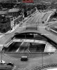
Six Ways Aston
- Thread starter Ian FOFB
- Start date
Ray Barrett
GONE BUT NOT FORGOTTEN R.I.P.
Carolyn,
About a fifteen minute walk...and you passed 6 pubs...
About a fifteen minute walk...and you passed 6 pubs...
Alf
Gone but not forgotten. R.I.P.
Carolyn,
About a fifteen minute walk...and you passed 6 pubs...
Would that be Park Lane Ray?
Ray Barrett
GONE BUT NOT FORGOTTEN R.I.P.
Alf,
I was thinking Victoria Rd.,Upper Sutton St.,Clifton Rd.,Upper Thomas St.and Tower Rd.
I was thinking Victoria Rd.,Upper Sutton St.,Clifton Rd.,Upper Thomas St.and Tower Rd.
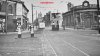
 This view of Six Ways Aston shows Victoria Road and the Baptist Church straight ahead and High Street off to the right. The very ornate bank with the turret on the right has gone as has the chemist's curved building to the left, although the row of buildings next door to the chemist's shop are still there today. This is the corner where Birchfield Road meets Witton Road. Even in the early 1900s this junction of roads was a busy road and of the 6 roads which met at this point, five had tramways passing through here. No wonder there's a policeman on duty to help people safely cross the road(s). Viv.
adap2it
master brummie
How very bland it looks nowView attachment 111990 This view of Six Ways Aston shows Victoria Road and the Baptist Church straight ahead and High Street off to the right. The very ornate bank with the turret on the right has gone as has the chemist's curved building to the left, although the row of buildings next door to the chemist's shop are still there today. This is the corner where Birchfield Road meets Witton Road. Even in the early 1900s this junction of roads was a busy road and of the 6 roads which met at this point, five had tramways passing through here. No wonder there's a policeman on duty to help people safely cross the road(s). Viv.
View attachment 111989
Dave A
Hi Mossg
just looking at your reply to carolyn saying 3 quarters of a mile from the aston cross
as ray said i think he was right , to be technicaly and to be honest as an old athlete
and a runner of miles i was say to be honest a 2 mile distance would be appropiate
To old six ways Aston, but sayin that i would not be surprized if it was 2 and half
and if the truth being know on foot half an hour walking it, if you was reasonably fit
best wishes as always Astonian,,,,,,,
cookie273uk
master brummie
Just checked on my A to Z, walking along park Lane its approx. 3/4 mile. Eric


I don’t have dates for this one but I’d guess around late 1890/1900 perhaps. Which roads are off to the left and right please ? Viv

Last edited:
In the drawing post #17 there seems to be a set of toll gates. But where exactly was this ? I can’t find any mention of toll gates at Aston Six Ways. There was one on Birchfield Road (near the old Crown & Cushion) but no mention of one at Six Ways. The roads which joined at Six Ways include:
Birchfield Road
High Street Aston
Lozells Road
Witton Road
Alma Street
Victoria Road
The one road with toll gates and the white house seems to be very raised up. Could this have been the junction of Witton Road and Birchfield Road ? On Streetview Birchfield Road rises up at that point. I just can’t seem to fit with the terrain shown in the later photos of Six Ways posted by Ian and Lyn - accepting obviously that this junction has considerably changed since the 1970s underpass development. Is there any description of the drawing anywhere ? Any date perhaps ? Or even a more precise location (ie the roads shown in the drawing) ?
Viv.
Last edited:
But if it’s written somewhere that it’s Six Ways Aston Lyn, isn’t it worth pursuing ? If there’s doubt we can try and resolve it one way or the other. I seem to remember seeing this before in a newspaper article. It was a very poor copy of the drawing but I vaguely remember it was given as Six Ways Aston. And at the time finding it hard to place. It could offer a snippet of history of interest. Viv.
yes you are right viv...i will leave it for members to debate as i guess it could just be right but i think drawings are harder to prove due to the artist adding or omitting certain things...But if it’s written somewhere that it’s Six Ways Aston Lyn, isn’t it worth pursuing ? If there’s doubt we can try and resolve it one way or the other. I seem to remember seeing this before in a newspaper article. It was a very poor copy of the drawing but I vaguely remember it was given as Six Ways Aston. And at the time finding it hard to place. It could offer a snippet of history of interest. Viv.
lyn
Last edited:
Banjo
master brummie
I'm hoping that members will find this interesting.
A couple of years ago I decided to make a DVD photographic record of Aston for my kids to see where we lived back then. Along with photos, I made a video image of Whitehead St which I have already posted to the Forum. That made me think that perhaps I could do more in the way of video imaging that my kids would find more immersive. So, I made one of Six Ways. Using various photos that were on the Forum, I adjusted perspectives and formed them into one overall image. There were some sections of this image, based on the viewing angle, I just couldn't find anywhere so, I filled in those myself after researching various other photos, maps, Kelly's etc.
As you can see, I have watermarked this copy as not real and is only based on my memory. As far as I'm aware, the photos used are in the public domain but, I'd like to thank everyone who posted those photos previously without which I could not have made it.
I hope it is acceptable to the Forum. Please delete if not.
Richard Dye
master brummie
Sure looks like Six Ways! Thank you for putting that together, very much appreciated!I'm hoping that members will find this interesting.
A couple of years ago I decided to make a DVD photographic record of Aston for my kids to see where we lived back then. Along with photos, I made a video image of Whitehead St which I have already posted to the Forum. That made me think that perhaps I could do more in the way of video imaging that my kids would find more immersive. So, I made one of Six Ways. Using various photos that were on the Forum, I adjusted perspectives and formed them into one overall image. There were some sections of this image, based on the viewing angle, I just couldn't find anywhere so, I filled in those myself after researching various other photos, maps, Kelly's etc.
As you can see, I have watermarked this copy as not real and is only based on my memory. As far as I'm aware, the photos used are in the public domain but, I'd like to thank everyone who posted those photos previously without which I could not have made it.
I hope it is acceptable to the Forum. Please delete if not.
mw0njm.
A Brummie Dude
must have been long long ago
Pedrocut
Master Barmmie

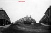
“The steam tram service through Newtown was the first to be operated by CBT, and ran between Old Square in the town centre and Perry Barr just beyond the Birchfield Road depot at the junction with Witton Lane. The route to Perry Barr was opened on 25 November 1884 and was linked to the Saltley route. Thus this steam tram and trailer has a SALTLEY destination slip board below the lower saloon windows as it works into Old Square and then out of town by way of Gosta Green, Great Lister Street, to the terminus just short of Saltley Viaduct. Both services continued until 31 December 1906 when the CBT lease expired, and the routes were taken over by the municipality on the following day. On conversion to an electric tramway, the Corporation only went as far as Newtown Row, as legal disputes prevented a through service to Perry Barr (this did not begin until 8 December 1909). Standing at Six Ways, Aston, with Victoria Road beyond the steam tram locomotive, the tram is on its way to Newtown and Birmingham.
Behind the tram, between Gash's chemist shop and Christ Church Baptist Chapel, is the entrance to Witton Road on the left. The church had been built in the 186o, and after many years of dereliction is now fitted out as luxury flats.“ (Commercial postcard)