A
-
Welcome to this forum . We are a worldwide group with a common interest in Birmingham and its history. While here, please follow a few simple rules. We ask that you respect other members, thank those who have helped you and please keep your contributions on-topic with the thread.
We do hope you enjoy your visit. BHF Admin Team -
HI folks the server that hosts the site completely died including the Hdd's and backups.
Luckily i create an offsite backup once a week! this has now been restored so we have lost a few days posts.
im still fixing things at the moment so bear with me and im still working on all images 90% are fine the others im working on now
we are now using a backup solution
You are using an out of date browser. It may not display this or other websites correctly.
You should upgrade or use an alternative browser.
You should upgrade or use an alternative browser.
A
Ann B
Guest
A
Ann B
Guest
A
Annveitch
Guest
Thanks Ann B iv,e just had a good look and got my bearings off "the smithy" which is still there, so the large house named the Chestnuts looks as if it was on the opposite side of what is now known as Sheldon Heath Road. the road just up from the smithy must be Horrell road and the road past the elms, the radleys.
A
Ann B
Guest
A
Ann B
Guest
Ann, Yes, The Smithy on Church Road is just before the junction with Horrell Rd., coming from the Coventry Rd.
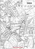
The map is of Sheldon in 1938 at the start of the thread, and includes Cockshutt Hill for new member Steve. With Cockshutt Hill School now showing.
Ann
The map is of Sheldon in 1938 at the start of the thread, and includes Cockshutt Hill for new member Steve. With Cockshutt Hill School now showing.
Ann
Last edited by a moderator:
A
Annveitch
Guest
it lay a little way back off the lane and it was on the bend of the lane just before where Mickleton Avenue is.
A
Annveitch
Guest
Ann B on the 2nd map just above where it says Garretts Green, there is something there that looks as if it could be buildings. I wonder if that was where the farmhouse was, that would be somewhere near Mickleton Avenue
A
Ann B
Guest
Ann,
I can see where you mean on the map, but I can't remember an old farm house there. We'll have to see if Lencops remembers it.
Ann
I can see where you mean on the map, but I can't remember an old farm house there. We'll have to see if Lencops remembers it.
Ann
A
Annveitch
Guest
I know there was deffinateley a white house on garretts green lane whether it was a farmhouse or maybe a farm workers cottage i don,t know.round about early 50s.
lencops
gone but not forgotten
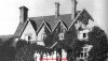
At the top of Church Rd hill going towards the Radleys on the right hand as i remember at the start of WW2 1939 there were about 8? shops the first shop was a newsagents and if you wajked past the side to the rear you would see The Elms Farm house, it was used during the war as hostel by BSA Machine Tools, Kitts Green for workers from all over GB who were sent to work there, it was still being used as hostel until circa1950?, later it was demolished and The Elms Farm estate was built. Len.
A
Ann B
Guest
Thanks Len. I don't remember the name of the community hall either. It's Elderfield Residential home on Garrett's Green. I'll check at the library then. It may have been compulsary purchased.
I bet a photo of it will prove elusive.
And I wish I had seen The Elms farm house.
Ann
I bet a photo of it will prove elusive.
And I wish I had seen The Elms farm house.
Ann
Hi Ann,
I think I can help you out on this One ... Elderfield Elderly Persons Home (Birmingham City council) was built on land that was previous buildings, (I worked there for a while!!) ... however Elderfield EPH is due to be demolished in the next 18 months / 2 years .. Elderfield EPH address is Meon Grove if this helps (not Garretts Green Lane )
I think I can help you out on this One ... Elderfield Elderly Persons Home (Birmingham City council) was built on land that was previous buildings, (I worked there for a while!!) ... however Elderfield EPH is due to be demolished in the next 18 months / 2 years .. Elderfield EPH address is Meon Grove if this helps (not Garretts Green Lane )
Hi Anne
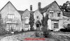
I will ask my Mom if she remembers the White House (she grew up in Lea Village) .. what I got confused with earlier was the picture of the Chestnuts ... now a church ? .. The Chestnuts I remember was and still is corner of Garretts Green Lane and Sheldon Heath Avenue, The church is further up Garretts Green lane heading towards Coventry Road/Barrows Lane.. another thought about a white building.. could that have been St bernards Grange ?
I will ask my Mom if she remembers the White House (she grew up in Lea Village) .. what I got confused with earlier was the picture of the Chestnuts ... now a church ? .. The Chestnuts I remember was and still is corner of Garretts Green Lane and Sheldon Heath Avenue, The church is further up Garretts Green lane heading towards Coventry Road/Barrows Lane.. another thought about a white building.. could that have been St bernards Grange ?
Last edited by a moderator:
A
Ann B
Guest
Diane,
Re The Chestnuts. The photograph is of the original house, that was called The Chestnuts, and was on Garretts Green, where the Church now stands. The Chestnuts Public House was named after it, but the pub was not built on the site of the old house. And is, as you said, on the corner of Garretts Green and Sheldon Heath.
Hope your mom can shed some light on Annveitch's white house. It maybe the one Len mentioned.
Ann
Last edited by a moderator:
A
Ann B
Guest
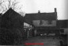
![The Smithy Church Rd Sheldon 1967[1].jpg](/forum/data/attachments/22/22474-897bf7b1507c7a267b371157aa95e77c.jpg)
Hi Bernie, the little road called the Smithy is quite new it is the entrance to the little row of houses built in the early 70s.Heading back to the Coventry rd just before Common lane there is another new road Romford Close i think,buillt mid 60s. They had to demolish 3 or 4 bungalows to make the new road entrance. The land behind the bungalows linked up to the Smithy and was used for crane hire company. Where Church rd changes to Sheaf lane ,just past st Thomas Moore's Church at the junction of Sheaf Lane and Mardon rd does any one remember the old cottage that was there.
A
Ann B
Guest
Hi Rowan,
I grew up opposite Cockshutt Hill cottage, from '49 to '65, and we used to go carol singing in Geneagles Rd. and Duncroft. There was a gulley from Cockshutt to Gleneagles Rd., and we'd go round the loop. At least in those days we used to go with our Hymn books and sing two or three carols. All they do these days is two or three lines. Hope your mom and dad gave us some pennies!
Ann
A
Annveitch
Guest
Len, the king of bohemia was in Comberton road the other side of Sheldon heath road to Mickleton avenue, (and it was a dump) the shops and the flats at the bottom of Mickleton Avenue have been demolished and is just open land. I did hear they wanted to turn the king of bohemia into a curry shop, but they were refused permission, i think its still standing but boarded up, but its been a long time since i was round there.
A
Annveitch
Guest

A
Ann B
Guest
Ann,
We used to go to Queens park as kids. And I was in the guides at the hall by the church. My mom was in the home opposite the Talbot at the end of her life. When I pushed her in her wheelchair round the park, I thought of her pushing me in my pram round the same park. It was a lovely park. I used to love the rose beds, the water drinking fountain and watching them playing tennis on the courts.
I vaguely remember a large pageant in the park in the '50's. All the school children took part in it.
Ann
A
Annveitch
Guest
I agree it was a lovely park but sadley like many other parks the flower beds and the park keepers have gone and they are just open spaces now.
the silver fox
master brummie
Sheldon is not an area I know much about despite the fact that the ultimate expert on the area, Victor Skipp, was an History teacher at Sheldon Heath Comprehensive, where I attended from 1956. I remember the first headmaster, Mr. Smith explaining how St Thomas, or possibly the local parish church dedicated to him, was (and still is) commemorated in the School's badge.
Ted
Ted
lencops
gone but not forgotten
I remember Head Master Mr.Humphries very well you did`nt want to be sent to his office if you could help it, Mr.Atyo was at Church Rd School, Yardley, and joined the RAF? i think, i remember him as a nasty little man, perhaps the war mellowed him, the Infants part of Church Rd was set up as an emergency hospital, this caused overcrowding in the Junior & Senior sections of the school that is why i ended up at Cockshut School i was 11yrs old and just about to go into the Seniors. I posted this on another thread titled Cockshut Hill School in can be found in search. Len.

rowan
Born a Brummie
AnnB ")
Our house backed onto the gully and I was friends with a girl who lived in Gleneagles Road, the corner house on the left hand side of the gully heading toward Cockshut Hill but sadly I can't recall her name.
Names I do recall are: Prosser: Butcher and Porter all who lived in "Little" Duncroft.
I remember the waste ground at the top of the road where we had dens and a huge bonfire on bonfire night.
There was another gully leading from Duncroft into Garretts Green road almost oppisite where we lived and can be seen clearly on the map. Our Doctor was just beyond the gully and his name was Dr. Khan.
We left Duncroft in 1952 to go to Sutton Coldfield.