• Welcome to this forum . We are a worldwide group with a common interest in Birmingham and its history. While here, please follow a few simple rules. We ask that you respect other members, thank those who have helped you and please keep your contributions on-topic with the thread.

    We do hope you enjoy your visit. BHF Admin Team
  • HI folks the server that hosts the site completely died including the Hdd's and backups.
    Luckily i create an offsite backup once a week! this has now been restored so we have lost a few days posts.
    im still fixing things at the moment so bear with me and im still working on all images 90% are fine the others im working on now
    we are now using a backup solution

Salford bridge

Hi mike
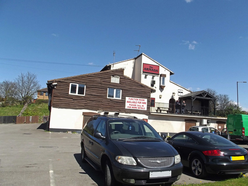
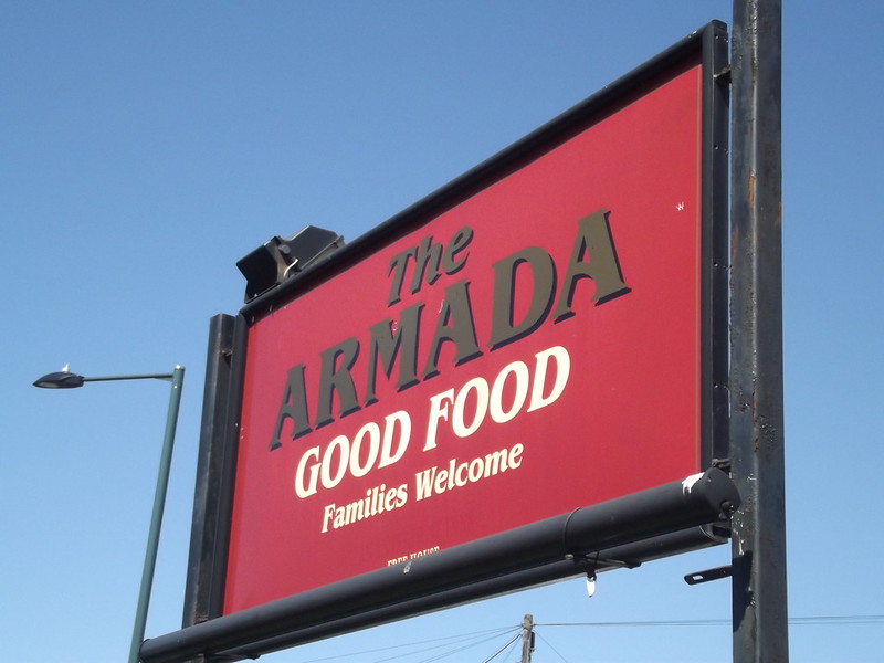
The Armarda was orininal called the ship then called the armarda on the corna of slade road before spaggitti
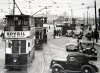
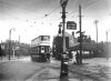
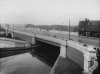
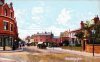
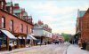
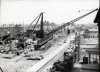
And long before that the old original salford bridge had little tiny shops on it one was a news agents
Along with the tram tun around back to the city
I recall these days and i also recall the tram crashes and turn overs more than once
All these old photographs was shangedhi by some nasty people whom have deprived us all
As some one recently said these old photographs will fetch a few bob in the not so distance future
There is some one putting these old picture on the phones as my old dutchess keeps showing me
which have been on this forum in the past , a couple of years ago my daughter got me a photograph
Of old birmingham from france when i asked her where she obtained it along with an very old bottle
Still getting back on to the subject of the bridge it would be nice if some one can produce a picture of the old bridge from the thirtys and fortys with all the little shops on best wishes Astonian,,,,,,
 
ellbrown, I'm not very good at reading these google images but I think it's the same one. Trying to get my bearings and I've just driven up the Lichfield Road (in my mind) and then I pass it before going left to Slade Road. It's hard to match up what pre-Spaghetti was to what it is now. There seemed to be a lot more than the space would allow. I suppose it's like when you take a tent down, the floor space seems much too small.
 
Astonian, I don't think the shops changed very much from when I first went in the early 50's to when they were knocked down. There are some of the shops in post #6 but here are a few of earlier ones which may have been on another thread. I think the last one is already on this thread but it has the shops.
 

Attachments

  • Salford Bridge A.jpg
    Salford Bridge A.jpg
    142.1 KB · Views: 79
  • Tram 647  Gravelly Hill, Erdington Arms.jpg
    Tram 647 Gravelly Hill, Erdington Arms.jpg
    151.2 KB · Views: 79
  • Salford Bridge  New Road Aston B83.jpg
    Salford Bridge New Road Aston B83.jpg
    136.9 KB · Views: 81
IMG_1471.jpg
The Salford Bridge as it is now with the Aston Expressway / Spaghetti Junction above it.


Down to the Tame Valley Canal


Towards Salford Circus


Salford Bridge from the Tame Valley Canal


Tame Valley Canal from the Salford Bridge


Thanks for the pictures. I found the following in the Archive concerning the opening of Salford Bridge in 1926...

Sir Arthur Herbert Drummond Ramsay Steel-Maitland (to give him his full name), opens the new Sanford Bridge in October 1926...note that he alludes to the coal stoppage as wholly unnecessary. He was MP for Erdington from 1918 to 1929, and Tamworth 1928 to 1935.

It appears that "A new residential area of Erdington had a road named after Arthur Steel-Maitland in December 2016."

I see we have a plaque to commemorate 40 years of being poisoned!
 
Hi Ladypenelope
many thanks for the picture and i wass around there in the fiftys
the ones i wanted and hoped to have seen was the early ones up to the fortys
and of course the big huge turn around table where they cranked the turn table around for the tram to head back to the city
best wishes Astonian,,,,,
 
No problem Pedro.

LadyP - got this photo of the Salford Bridge with the M6 going over it. I think it's the direction heading north west.


On the Google Map, the M6 is to the left, and the canal island is on the right.

 
Lady P, the area was great when we moved there in 1962 and though there was considerable disruption when the M6 and spaghetti was built it was still a nice area to live (Hillside Rd in my case). It started to change end of 70's, all our old neighbours started to leave and we followed suit in 1987 and moved to Chelmsley Wood. Sorry to leave after 25 years but we could see the way it was going. Re the Pub , it could have been called the Amada and not the Erdington Arms, (Frothy would know), locally it was known as the Muckman from the days when the 'night soil' gentlemen frequented it. Eric
 
Nov 1890, Birmingham Daily Post…The Strange death of an Aston Guardian..

A cabman said that the deceased man got into his cab to go to Minworth. He was the worse for drink. On the way the deceased called at the Muckman’s Rest…The Coroner…”Naturally for repose, (laughter) that’s hardly a respectable name for a Guardian’s place of call. The Erdington Arms, isn’t it?” Witness…”Well the Muckman’s Rest is what we cabmen call it…”
 
Hi Eric & Pedrocut, I have heard that the Muckman was so called because the dustmen used to call in there but I'm sure my Dad said it was something to do with the maltsters taking the waste away. I wonder if the pub did their own brewing? Perhaps this was their last stop before home? Not sure of the brewing process but there must be waste as the end of it.

Ellbrown, I'm sure it's the same island now that you have posted those pics. Thank you. Not much to show for what was there before is there?
 
It might be the Salford Bridge Toll Stop

Salford Bridge Toll Stop is a minor waterways place on the Birmingham Canal Navigations (Tame Valley Canal) between Tame Valley - Rushall Junction (Junction of the Tame Valley and Rushall Canals) (4 miles and 7¾ furlongs and 13 locks to the northwest) and Salford Junction North (Junction of B&F and Tame Valley Canals) (¼ furlongs to the east).


The nearest place in the direction of Tame Valley - Rushall Junction is Spaghetti Junction A38 Bridge; ¾ furlongs away.

The nearest place in the direction of Salford Junction North is Salford Bridge; ¼ furlongs away.
The place is a toll stop.
 
Hi Astonian, I don't remember these turntables you mentioned. Must've been before my time. I will try to find out about them as when the tram got to our terminus the driver just got off the front and got on the back to retrace the journey, if you see what I mean. I didn't know they turned them round at Salford Bridge. Not sure when the 78 was first used but I think the No. 6 went to Stockland Green before that. I believe the No. 2 went to Erdington but whether it continued to the Sutton Coldfield border originally I don't know. I'll see what I can find out and get back to you.
 
IMG_1473.jpg

As this clip from 1914 shows there was a sewage farm at Gravelly Hill, where the "night soil" gentlemen could take their night soil!


Lady P, the area was great when we moved there in 1962 and though there was considerable disruption when the M6 and spaghetti was built it was still a nice area to live (Hillside Rd in my case). It started to change end of 70's, all our old neighbours started to leave and we followed suit in 1987 and moved to Chelmsley Wood. Sorry to leave after 25 years but we could see the way it was going. Re the Pub , it could have been called the Amada and not the Erdington Arms, (Frothy would know), locally it was known as the Muckman from the days when the 'night soil' gentlemen frequented it. Eric
 
There was an enormous sewage farm to the east of Salford Bridge, where sewage was spread on fields. this was developed from 1865. The purchase of esome of the land is mentioned in the 150 years thread recently. When treatment methods improved and bacterial filtration was introduced in 1898, the area was considerably reduced.
 
Thanks Everyone, that sounds more likely to be muck doesn't it? I'd forgotten about the sewage farm and yet my Gt Uncle Edward worked there in the early part of the 20thC. He died from typhoid caught there. He was only in his 20's and left a widow and small daughter.
 
The sewage farm was where Gravelly Industrial Park is now. I think it was called the Tame and Rea Drainage Board. It has a narrow-gauge railway.

There is a row of houses on Standard Way that were known at the Drainage Board Cottages.

They did away with this site after building a huge sewer pipe along Tyburn Road to Minworth in the 1960’s
 
IMG_1474.jpg
The sewage farm was where Gravelly Industrial Park is now. I think it was called the Tame and Rea Drainage Board. It has a narrow-gauge railway.

There is a row of houses on Standard Way that were known at the Drainage Board Cottages.

They did away with this site after building a huge sewer pipe along Tyburn Road to Minworth in the 1960’s

A picture from the Sphere of November 1957, the construction of the tanks at Minworth.
 
I found these two pictures yesterday on Facebook (thank you Facebook). The first one is an angle I don't recall seeing before and shows houses which I don't remember. I think it shows Minstead Road on the left. There's a vehicle outside the pub which might help date it. Would it be pre-Tyburn Road?

Update on the Armada: The pub is still open and I understand that it may be being used as a B & B. Hence the number of vehicles parked outside.
 

Attachments

  • Gravelly Hill 2.jpg
    Gravelly Hill 2.jpg
    137.8 KB · Views: 75
  • Gravelly Hill.jpg
    Gravelly Hill.jpg
    130.1 KB · Views: 76
Viv, I had seen you pictures before but until you posted them I hadn't realised how many buildings were demolished to make way for Tyburn Road so thank you. It was comparing them to the two PC's I posted and it was wider than I thought. I wonder when the shops were built (post #40 pic 1) and the houses opposite? I must have another look at the other thread for Salford House.
Just having a look at Lyn's picture B77 again. The properties in the centre of the picture appear to be newly demolished but surely this is later than the building of Tyburn Road? Perhaps it was widened at the same time the bridge was being re-built?
 

Attachments

  • Salford Bridge B77.jpg
    Salford Bridge B77.jpg
    419.6 KB · Views: 63
Hi Lady P. I think your two images in post #40 are probably dated between 1890 and 1900. Maybe this will help. Seems almost impossible that it once looked like that. Village-like. Viv.
 
This might be of interest to get your bearing of the Erdington Arms and the Armada. 1919 map overlaid with a modern day map. As you see the Erdington Arms was more or less in the middle of Salford CircusSalford bridge.PNG
 
I went past The Armada in April 2015, near Salford Circus, when I got the train to Gravelly Hill.


IMG_1484.jpg

For sale in July 1827...Copeley...

that romantic spot, adjoining Salford Bridge and near the admired village of Aston...approximating to Guy's Cliff, with a superiority of aspect...formed by the hand of Nature, that never can be built upon so as to obstruct the varied and extensive scenery of the surrounding country....A great portion is skirted by Hawthorn Brook, falling into the River Tame at Dwalf-Holes and is part of the estate....and equally beautiful vistas along meadows, glens and streams towards Saltley and Witton...
 
Hi Ladypenelope
yes it must have been before your time i am sorry to hear
I used to walk down there regular as a nipper plus the fact i can tell you we did have them on here
about ten or so years ago until the robbers highjacked us all by taking the photographs
we had several and i was rather hoping that some one may have had one to produce
but obvisiuosly no one as got one
i would only say its the prevuios members whom are no longer with us would possibly have one in there possion
Oh well may be one day we will get one, there are alot of threads coming back on as i see it
New members asking the same old questions as to what we had on here yeas ago
the huge turn table was a huge table about the with of the road and it was turned and cranked manualy
to change the tracked for ever which way route it gonna take and it also turned around to head back to city and miller street
I have got a couple of books on the tramms and i will try and find one out if possible
and some that toppled over as well best wishes Astonian,,,,,Alan,,,,
 
In the above advert of 1827, the terms Guy's Cliff and Dwarf-holes appear. Has anyone ever heard them mentioned before?
 
Back
Top