Terence David Lines
master brummie
I used to swim in the river Cole just below where it was joined by Chinn Brook downstream of Trittiford Park boarder of Yardley Wood and Hall Green 1954ish.
The brook your talking about runs underneath Witon Lodge Road, and although the area is regenerated . The houses mainly Dovedale Road, and Maxted Road the brook runs yards from the back of their gardens.Eric Gibson refers to "The brook" that ran from Finchley Park along the back gardens of Hurlingham Road. I believe originally it was known as Hawthorn Brook. I think Lodge pool was probably where the old prefab island is in Warren Farm Road. The ground rises quite steeply each side and the Brook is now culverted in some places that were once open.
From our adventures as small boys (I lived in Cranbourne road), The Brook as Eric says, was open along Hurlingham Road. It Went into a blue brick tunnel under the island at Sidcup Road then opened along Cranbourne road before another curved tunnel under Danesbury Crescent, then opened up along Warren Farm Road prefabs.
Back into a long tunnel, until near Elswick Road. Somewhere near there, my pal climbed up some iron steps and popped a man hole cover in someone's back garden. He was firecly beaten back down by an old lady with a broom!
It eventually joined under Finchley Road (I think), with an arm that ran out of Finchley Park and along the rec, under college Road and on to Witton Lakes.
From what I learned as a kid, it started somewhere near Rough Road reservoir., and split, at Finchley Park, one arm directed through the rec and playing fields,
the other skirting the pimple (kingstanding beacon) and through the estate.
It was a natural Brook but redirected when Warren Farm Estate was built 1929, 1931. It was straightened and curved to accommodate the shape of the housing estate. There were various pipes layed to empty storm drains, and man holes with iron steps, some in the middle of the roads.
During heavy rain it carried a huge and potentially dangerous volume of water, sometimes flooding the back gardens along it course, before emptying into Witton Lakes.
Our parents would tell us never to go down there as it might harbour Polio and Black fever. Happy days.
You may find the problem with flooding is not understood properly by the environment and water boards. I used to fish the river Arrow just downstream of Wixford.The brook your talking about runs underneath Witon Lodge Road, and although the area is regenerated . The houses mainly Dovedale Road, and Maxted Road the brook runs yards from the back of their gardens.
Although foliage now covers the banks, and it’s very hard to see the brook.
From under Witton Lodge Road it then appears in what was Perry Common Recreation Ground it then flows under Perry Common Road, and emerges on Witton Lodge park going into the lakes.
Interesting you said about flooding we used to live 2 houses from the brook on Witton Lodge Road. There are only 4 detached houses overlooking the then recreation ground we were one of them.
I was told the ground our houses stood was a builders yard years ago, and it flooded, I’m not sure how because the ground was at least 20 feet higher than the brook.
However the recreation ground flooded in a flash storm in 2013.
The brook back flowed and gardens were flooded in Dovedale Road.
The causes was a tree had grown across the brook on the RG, and caused a log jam.
My husband had the presence of mind to take photos of how much flooding on the RG there was.
Birmingham City Council were in the process of almost starting building houses on the RG, convinced that flooding never would happen.
However, they had to go back and rethink their plans because of the photos, really it was a fluke regarding the flooding because of the tree, but unless the brook is maintained it could well happen again.
They have built houses on a third of the RG, but put in I think they are called Swales, big ugly drains, but I still think the volume of water is a problem there to some degree. Also there is a culvate in Witton Lode Road that runs water into the brook from I don’t know where.lol
However, I have noticed that Perry Common Road were the brook runs under is now flooding when we have heavy rain fall.
I lived in Cranbourne Road opposite Tansley Road cannot remember any brook.
Hi DianeThe brook your talking about runs underneath Witon Lodge Road, and although the area is regenerated . The houses mainly Dovedale Road, and Maxted Road the brook runs yards from the back of their gardens.
Although foliage now covers the banks, and it’s very hard to see the brook.
From under Witton Lodge Road it then appears in what was Perry Common Recreation Ground it then flows under Perry Common Road, and emerges on Witton Lodge park going into the lakes.
Interesting you said about flooding we used to live 2 houses from the brook on Witton Lodge Road. There are only 4 detached houses overlooking the then recreation ground we were one of them.
I was told the ground our houses stood was a builders yard years ago, and it flooded, I’m not sure how because the ground was at least 20 feet higher than the brook.
However the recreation ground flooded in a flash storm in 2013.
The brook back flowed and gardens were flooded in Dovedale Road.
The causes was a tree had grown across the brook on the RG, and caused a log jam.
My husband had the presence of mind to take photos of how much flooding on the RG there was.
Birmingham City Council were in the process of almost starting building houses on the RG, convinced that flooding never would happen.
However, they had to go back and rethink their plans because of the photos, really it was a fluke regarding the flooding because of the tree, but unless the brook is maintained it could well happen again.
They have built houses on a third of the RG, but put in I think they are called Swales, big ugly drains, but I still think the volume of water is a problem there to some degree. Also there is a culvate in Witton Lode Road that runs water into the brook from I don’t know where.lol
However, I have noticed that Perry Common Road were the brook runs under is now flooding when we have heavy rain fall.
I lived in Cranbourne Road opposite Tansley Road cannot remember any brook.
Yep, between the prefabs was where us kids used to climb over the railings and follow the brook all the way to witton lakes..It was quite a large open section in Warren Farm road. The footbridge of the brook there, was crazy paved with a picture of the Birmingham coat of arms.Well that’s a surprise Mort. Thanks. Must have been well hidden. Viv
Well done, Daimlerman!Well well well, after a lot of digging and research today I finally found the correct names of the Brooks through Kingstanding. I was trying to find plans and construction notes for Warren Farm Estate.
Using old OS maps didn't really pin-point a definitive start point but by chance I came across a Birmingham Corporation flooding risk assessment of about 285 pages.
Eventually I came across Witton lakes and its feeder Brooks. I found a highlighted page (don't ask me where) showing clearly the open brook and culverts spoken about previously.
Eric Gibson states in his post he and his pals would follow the brook (upstream) underground in tunnels from the open section along Hurlingham Road and reach the overflow of the pond in Finchley Park. This route is WARREN BROOK.
Going downstream from Hurlingham Road, Cranbourne road, Warren Farm road , Warren brook empties Into HAWTHORN BROOK after passing under College Road. Hawthorn brook also passes through the pool in Finchley Park which in turn is part of a natural water course rising somewhere towards Sutton Park. I also believe it also carries excess water from the underground reservoir on Rough road.
It all empties into Witton lakes, which is also fed from another brook, from the opposite side of the lakes known as SHORT HEATH BROOK.
Well, I hope that clears up the mystery.( for me at least). We now know they are natural watercourses and if nothing else I'm happy to have established which name belongs to which section. I hope you enjoyed the voyage. Phew!
Excellent job, thanks. Was there any further information on the origins of Shortheath Brook? It disappears into a long tunnel in parkland of streeley Road in the direction of Station Road. As kids we would venture up so far, but it seems mile long with no end in sight.Well well well, after a lot of digging and research today I finally found the correct names of the Brooks through Kingstanding. I was trying to find plans and construction notes for Warren Farm Estate.
Using old OS maps didn't really pin-point a definitive start point but by chance I came across a Birmingham Corporation flooding risk assessment of about 285 pages.
Eventually I came across Witton lakes and its feeder Brooks. I found a highlighted page (don't ask me where) showing clearly the open brook and culverts spoken about previously.
Eric Gibson states in his post he and his pals would follow the brook (upstream) underground in tunnels from the open section along Hurlingham Road and reach the overflow of the pond in Finchley Park. This route is WARREN BROOK.
Going downstream from Hurlingham Road, Cranbourne road, Warren Farm road , Warren brook empties Into HAWTHORN BROOK after passing under College Road. Hawthorn brook also passes through the pool in Finchley Park which in turn is part of a natural water course rising somewhere towards Sutton Park. I also believe it also carries excess water from the underground reservoir on Rough road.
It all empties into Witton lakes, which is also fed from another brook, from the opposite side of the lakes known as SHORT HEATH BROOK.
Well, I hope that clears up the mystery.( for me at least). We now know they are natural watercourses and if nothing else I'm happy to have established which name belongs to which section. I hope you enjoyed the voyage. Phew!


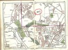
thank you.Morturn you should be able to see Short heath brook and Erdington brook at the lower right of this shot.View attachment 175305
Any connection with Chad Valley Toys?Chad Brook rising in Harborne, running through Edgbaston and feeding Edgbaston Pool and on to join Bourn Brook.
I believe one of the sites for Chad Valley Toys was right next to Harborne Station in Station Road - somewhere on the internet there are photos of all the materials sitting very close to the platforms. It mentions the Harborne site in this article: https://www.birminghammail.co.uk/news/nostalgia/gallery/factory-floor-chad-valley-1960s-23395008Yes, I think there are other documents supporting the Chad Valley connection. The logo with the valley and the brook must have been what it looked like in the very early days of the business / factory!
Try post 19 on this thread - https://birminghamhistory.co.uk/forum/index.php?threads/chad-valley-toy-company-ltd-harborne.12918/ - scroll down to pic chad _ 003.I believe one of the sites for Chad Valley Toys was right next to Harborne Station in Station Road - somewhere on the internet there are photos of all the materials sitting very close to the platforms. It mentions the Harborne site in this article: https://www.birminghammail.co.uk/news/nostalgia/gallery/factory-floor-chad-valley-1960s-23395008
Thimblemill Brook is now the name of a nature reserve based on Thimblemill Pool at the junction of Norman Road and Thimblemill Lane. It used to be the GKN recreation ground. I see now part of the brook remains unculverted in Stanhope Road, Valley Rd and Broadmore Avenue. But I had no idea that the brook stretched for 3 miles.Thimblemill Brook rising in Smethwick and flowed 3miles to join Hockley Brook. £750,000 plan to culvert entire length in 1965.