• Welcome to this forum . We are a worldwide group with a common interest in Birmingham and its history. While here, please follow a few simple rules. We ask that you respect other members, thank those who have helped you and please keep your contributions on-topic with the thread.

    We do hope you enjoy your visit. BHF Admin Team
  • HI folks the server that hosts the site completely died including the Hdd's and backups.
    Luckily i create an offsite backup once a week! this has now been restored so we have lost a few days posts.
    im still fixing things at the moment so bear with me and im still working on all images 90% are fine the others im working on now
    we are now using a backup solution

Problem solving for those who know Balsall Heath

mikejee

Super Moderator
Staff member
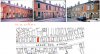
This is really an adjunct to my series of photos on thread Birmingham 1969-73. The three views below were taken around 1970 in the Balsall Heath are and are consecutive , thus showing a line of terraced houses, For some unknown reason I have at soem time labelled them as Court Road. They were taken on the film immediately before some on Mary St and Balsall Heath Road (though I cannot be certain it was on the same day). Having examined the layout of the back-accesses compared to recent maps, and the look of the present houses (which seem admittedly to have been considerably altered) I am very dubious of them being court road., Although I should add that the original c1889 maps do show more rear accesses.There is also the point that the house on the far left in photo 1A seems to show either 17 or 27 as a number, which definitely does not fit with it being Court Road.
Any comments would be welcome
0A..jpg1A..jpg2A..jpgmap c1951 court road.jpg
 
I've just sharpened & blown it up a bit - most likely 11 and certainly the first number is 1

Maurice :cool:
1A_number.jpg
 
As you can see from the map, although it does not show no 11 , which would be on the rounded corner, this is confirmation that it is not court road..
 
My thoughts are:
As you say it's not Court Road.
It looks like number 27 to me.
The entries on 1A and 2A have signs above them, I think one of them leads to a court at the back because on 1A there is a double chimney showing which doesn't belong to the houses fronting the road. My feeling is that the court is accessed by the 'very posh' entry on 2A.
Just my thoughts and I do enjoy these intrigues.

Could it be Lincoln Street?
 
Last edited:
for lincoln /St, as can be seen, both 11 and 27 have an entry next to them, Have enlarged the sign, and it seems to say Meya villas.

map c1950 lincoln st.jpg2 Bpart.jpg
 
The street map attached shows Upper Cox Street, I don't think for one minute that this is the street in question but it serves as an illustration of the entry arrangement i.e. 5 houses/entry/3 houses/entry/2 houses/entry
 

Attachments

  • Config.jpg
    Config.jpg
    375.4 KB · Views: 19
Mike,

Does the reg. no. of that black van in 2A help - LUU562D ?? It doesn't appear to be local so possibly owned by a business. The other vehicle reg nos. are not readable.

Maurice :cool:
 
There is a number on the white and black door of 2A (behind the ford corsair?) if somebody is able to enhance it.
 
Mike,

Does the reg. no. of that black van in 2A help - LUU562D ?? It doesn't appear to be local so possibly owned by a business. The other vehicle reg nos. are not readable.

Maurice :cool:

A 1966 London registration. I know crediit drapers, such as Blundells used them and I guess so did many other companies.
 
Meya Villas could be worth exploring on the census or within trade directories, not forgetting of course, that some street names changed. For example, Lincoln Street used to be called Norton Street.
 
No Meya Villas in the censuses, Keiron, and those names, since the houses are numbered, don't tend to get used in trade directories. The only Google entries are faraway, such as Indonesia.

Maurice :cool:
 
Brummy Lad. i think you have it. If the somewhat unclear no was 27 , which is not impossible, then this would fit. But I have some other information which I was working out last night, that would seem to go with this. Following these three photos there is another photo (below) with a number 12 against it, and with an entry to the right of it. The next I had already identified as the back of Mary Road School, in Upper Cox St, and this, I realized last night, is just opposite the back of Mary St School.
On the whole this convinces me that your identification is correct and I will add these to my 1969-73 thread with appropriate information.

3A.jpg
 
I was confused by the chimneys which appear to be at the back of the houses in 0A but the picture above shows them to be part of the same house. What are your thoughts on that? Would the houses have had a chimney in a front and back room do you think?
 
I cannot see why these houses had to be demolished, particularly Meya Villas. Good solid housing stock with attractive hood mouldings above the windows and doors. They should have been renovated.
 
Kieron
That would probably apply to many houses around Birmingham . Phil, who was involved in the demolition and , occasionally renovation, of many properties at that time, has often made the point that, although there was much sub-standard building, there were also many well built buildings of character that could have been retained
 
I found this reference to Princess Place behind Nos. 15&16 but can't find any reference to Meya Villas unfortunately.
 

Attachments

  • princess place.jpg
    princess place.jpg
    951.5 KB · Views: 7
I have found it impossible in a number of other cases to find any reference to the enscribed name of the place on electoral rolls and censuses, only back of or court no. But I am convinced of the identification as it goes with a route, going north up upper cox st, past nos 11,12 and the back of the school opposite, and then to corne rof Balsall heath road, along balsall heath road and then into Mary st. I will be putting these photos on the main 1969-73 thread with additional information as to buildings that I can find
 
I have found it impossible in a number of other cases to find any reference to the enscribed name of the place on electoral rolls and censuses, only back of or court no. But I am convinced of the identification as it goes with a route, going north up upper cox st, past nos 11,12 and the back of the school opposite, and then to corne rof Balsall heath road, along balsall heath road and then into Mary st. I will be putting these photos on the main 1969-73 thread with additional information as to buildings that I can find
Yes Mike, I'm totally convinced too. In my post #8 for some reason (tired brain perhaps) I thought the house numbers were even in which case the house next to the one I coloured blue would have been 28. It's only when I reread your post I realised it was 27, so in fact it all fits perfectly.
I can also understand why some people would put the name of 'Princess Place' on their census return, they must have felt quite special being in an exclusive club of only 4 properties. The title 'Meya Villas' on the other hand doesn't seem quite as prestigious.
 
Kieron
That would probably apply to many houses around Birmingham . Phil, who was involved in the demolition and , occasionally renovation, of many properties at that time, has often made the point that, although there was much sub-standard building, there were also many well built buildings of character that could have been retained
I remember - having lived in Balsall Heath between 1974 and 1977 - that there were two quite distinct sides to it. The Moseley side of Edward Road consisted of fairly well kept Edwardian terraces which - according to Google Maps - are still there though obviously most have had new windows and often doors. The City side consisted of very scrubby waste ground, derelict or heading-that-way streets/shops/deserted businesses, all of which were gradually being demolished; Maps shows airy streets of modern housing there now.

I converted some 1975 slides today showing quite a lot of the derelict B.Heath - anyone interested in seeing them?.
 
Last edited:
I remember - having lived in Balsall Heath between 1974 and 1977 - that there were two quite distinct sides to it. The Moseley side of Edward Road consisted of fairly well kept Edwardian terraces which - according to Google Maps - are still there though obviously most have had new windows and often doors. The City side consisted of very scrubby waste ground, derelict or heading-that-way streets/shops/deserted businesses, all of which were gradually being demolished; Maps shows airy streets of modern housing there now.

I converted some 1975 slides today showing quite a lot of the derelict B.Heath - anyone interested in seeing them?.
hi tidd...i am sure a lot of our members would love to see your slides...thank you

lyn
 
I would think here is perfectly acceptable
 
Last edited by a moderator:
Back
Top