Article below
is courtesy of Carl Chinn who wrote it for the Birmingham Mail
Its Hard to think of greenery in the old Nechells dominated as it was by the gasometers of Nechells Place and Windsor Street, marked out by railway lines, overlaid by back to backs, and darkened by factories and workshops billowing out smoke and pollution
Yet green there had been.
The first notice of the actual name Nechells is in a deed from 1339 whereby William Holdon granted lands in Echeles to Henry son of Robert Jordan of Erdyngton.
Joe McKenna, who has written a cracking book on Birmingham's place names, feels that the meaning of the name is open to speculation - although it might derive from the Old English 'ecels', signifying cleared land added to an existing farm.
His hunch is supported by compelling evidence from the place-name expert Kenneth Cameron. He explains that originally Nechells was known as 'atten_ Eccheles', the land added to a village.
As time went, in a process called metanalysis, the 'n' from 'atten' was taken as belonging to Eccheles, thus giving atte Neccheles.
In the following years, the word 'atte' was dropped completely. It is -likely that this linguistic change occurred in the Middle English period, which would suggest that it took place some time in the 12th century. This dating is given validity by the first use of the word in 1339. Interestingly, Geoff Bryant and other people have told me that older Nechells folk used to pronounce the name as Netchells.
The roots of the name would suggest that this was the original way in which the word was spoken. From its earliest appearance, the manor of Nechells was always linked with the manor of Duddeston. However, there is no evidence of a village in Duddeston and as both places lay in the parish of Aston, it would seem that Nechells may have been the land added to Aston village.
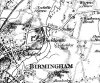
In his history of Warwickshire, William Dugdale wrote there had been a 'pretty village' in Nechells itself, but again there is no corroboration for such an assertion. The existence of a village does seem most unlikely. Certainly the lack of population locally is emphasised by Tomlinson's Map.
This indicated less than a handful of houses and gardens, including those of someone called Bott on Netchells Green, and close to the future High Park Street. The place name green comes from Anglo-Saxon grene. It could mean either a grassy place or a village green, as in The Green at Kings Norton. Given that there was no village locally, it must be that Nechells Green was a grassy place.
However, it was a focal point in the 18th century and its importance as a central location in Nechells increased when the district was built up from the mid-1850s.
Nechells Green is the most-eye-drawing feature of Tomlinson's Map. It consisted of two large pieces of land that lay between fields and which were separated by a route that headed down towards Aston and would become known as Thimblemill Lane, after a mill where thimbles were made.
This was an important lane as it led toward Aston Parish Church, where Nechells and Duddeston folk had to Worship by law.
Also part of the Green was a small triangle of land bounded by two other routes. The first was a path that split into two at the apex of the triangle. It went down hill from Nechells Green, as it was given on the map, and was indicated as the road towards Perry Barr. This was to become Rocky Lane, which later ended at Aston Cross.
The other way that made the triangle headed into Duddeston and is still with us as Bloomsbury Street and Vauxhall Road. It went on to just below Lower Gorsty Green. This later disappeared as a name, although its location survived until the twentieth century in the little triangle of land in between AB Row, Prospect Row and Belmont Row. Upper Gorsty Green has carried on as Gosta Green.
Belmont Row itself would run into Lawley Street, again shown as a track on Tomlinson's Map and which after crossing the River Rea would split in two to go to Small Heath and Camp Hill.
As for the track that became Bloomsbury Street this was joined by another route that led to Saltley Bridge over the Rea, and which later emerged as Saltley Road and Saltley Viaduct; and further on down by- one other pathway that made for Duddeston Mill - hence becoming Duddeston Mill Road.
It is remarkable that the ancient routes coming from Nechells Green were not obliterated by either the urbanisation of Nechells or by its wide-scale redevelopment in the 1950s and 1960s. It is also remarkable that the name of Nechells Green was not wiped out.
From 1838, when it became part of Birmingham, Nechells was a. spur of the town enveloped by rural Aston and Saltley.
Located distantly from the centre of the expanding Bruin, the area was developed only from the mid-19th century. The first streets to be cut were those between Great Lister Street and Nechel& Green - but, as with other parts of Birmingham, the countryside was not banished immediately.
These streets below the Green were cleared of their housing and. reformed in the post-war redevelopment of our city. High -: flats and maisonettes came to"' dominate the sky line. With parts of Duddeston, the neighbourhood has now been refashioned once more