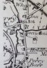
Perry Village is a place that's now absorbed into the general Perry Barr area. But only 100 years ago it would still have been a rural hamlet. According to this 1904 OS map Perry seems to have clustered along Church Road (although I did wonder if it's exact spread might have included Little Perry and Great Perry shown on the 1834 map at the end of this post).

1904 OS map of Perry
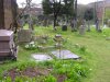
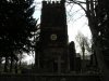
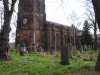
St. John the Evangelist Church on Church Road would have been a key feature of the Village as would Perry Villa. The 1838 Villa, built from the stones of a former Roman camp, was once a rectory, but in later years was used as a residential nursery in the 1940s. After the nursery closed it was used as a Civil Defence training centre for dealing with unexplored bombs. It has since been demolished.
Perry Village also once had a police station, a Village Farm and a number of cottages. Images of the Village, the police station, Perry Villa and Ye Olde Oak Stores (corner of Church Road and Aldridge Road) are in the next post. Viv.
1904 OS map of Perry
St. John the Evangelist Church on Church Road would have been a key feature of the Village as would Perry Villa. The 1838 Villa, built from the stones of a former Roman camp, was once a rectory, but in later years was used as a residential nursery in the 1940s. After the nursery closed it was used as a Civil Defence training centre for dealing with unexplored bombs. It has since been demolished.
Perry Village also once had a police station, a Village Farm and a number of cottages. Images of the Village, the police station, Perry Villa and Ye Olde Oak Stores (corner of Church Road and Aldridge Road) are in the next post. Viv.
Attachments

Last edited: